Category:Kirkden
Jump to navigation
Jump to search
Scottish parish in Angus, Scotland, UK | |||||
| Upload media | |||||
| Instance of | |||||
|---|---|---|---|---|---|
| Location |
| ||||
| Population |
| ||||
| Area |
| ||||
 | |||||
Media in category "Kirkden"
The following 134 files are in this category, out of 134 total.
-
 A germinating crop, Dumbarrow - geograph.org.uk - 5173124.jpg 1,024 × 768; 352 KB
-
 A road near Dumbarrow Mill - geograph.org.uk - 5173113.jpg 1,024 × 768; 592 KB
-
 A small wood in Angus - geograph.org.uk - 5173109.jpg 1,024 × 768; 593 KB
-
 A932 - geograph.org.uk - 4540031.jpg 800 × 533; 483 KB
-
 Arable land, Dumbarrow - geograph.org.uk - 5173116.jpg 1,024 × 768; 234 KB
-
 Arable land, Fallady - geograph.org.uk - 5171984.jpg 1,024 × 768; 336 KB
-
 Arbroath and Forfar Railway - geograph.org.uk - 3609232.jpg 640 × 480; 369 KB
-
 Arbroath and Forfar Railway - geograph.org.uk - 3609236.jpg 640 × 480; 371 KB
-
 Arbroath to Letham road, Dumbarrow - geograph.org.uk - 5173122.jpg 1,024 × 768; 440 KB
-
 Back Boath - geograph.org.uk - 6188795.jpg 5,184 × 3,888; 5.4 MB
-
 Barley, Pitmuies - geograph.org.uk - 3609239.jpg 640 × 480; 317 KB
-
 Bird scarer - geograph.org.uk - 5171982.jpg 1,024 × 768; 380 KB
-
 Blairs of Dumbarrow - geograph.org.uk - 6188778.jpg 5,184 × 3,888; 5.57 MB
-
 Bluebell Bend - geograph.org.uk - 2508907.jpg 3,456 × 2,304; 2.18 MB
-
 Bractullo - geograph.org.uk - 3608558.jpg 640 × 640; 343 KB
-
 Bractullo Bridge - geograph.org.uk - 3608565.jpg 640 × 480; 319 KB
-
 Bractullo Mill - geograph.org.uk - 6587922.jpg 1,024 × 683; 155 KB
-
 Bridge buttresses, Friockheim - geograph.org.uk - 3609265.jpg 640 × 480; 302 KB
-

-
 Bridgend, Letham - geograph.org.uk - 6188773.jpg 5,184 × 3,888; 5.63 MB
-
 Burn, Friockheim - geograph.org.uk - 3609259.jpg 640 × 480; 357 KB
-
 Cottage on Westgate, Friockheim - geograph.org.uk - 4561711.jpg 4,608 × 3,456; 3.17 MB
-
 Cotton of Gask Wood - geograph.org.uk - 5903548.jpg 1,024 × 683; 467 KB
-
 Cross slab - geograph.org.uk - 1443573.jpg 480 × 640; 139 KB
-
 Dismantled Railway - geograph.org.uk - 6384275.jpg 1,024 × 670; 275 KB
-
 Doocot, House of Pitmuis - geograph.org.uk - 1832576.jpg 640 × 480; 94 KB
-

-
 Dumbarrow windmill - geograph.org.uk - 5173126.jpg 1,024 × 768; 274 KB
-

-
 Eryngium in Pitmuies garden - geograph.org.uk - 1981477.jpg 640 × 640; 260 KB
-
 Fallen beech, Mains of Gardyne - geograph.org.uk - 5171991.jpg 1,024 × 768; 348 KB
-
 Farm cottages at Pitmuies, Angus - geograph.org.uk - 5016424.jpg 4,507 × 3,381; 3.39 MB
-
 Farm road to Ascurry - geograph.org.uk - 3232536.jpg 1,200 × 797; 469 KB
-
 Farm road to Ascurry Mill - geograph.org.uk - 3232537.jpg 1,200 × 797; 559 KB
-
 Farm road to Blairs of Dumbarrow - geograph.org.uk - 3232699.jpg 1,200 × 797; 482 KB
-
 Farm road to Hillkirk - geograph.org.uk - 3232539.jpg 1,200 × 797; 539 KB
-
 Farmland at Legaston - geograph.org.uk - 5167873.jpg 640 × 480; 73 KB
-
 Farmland at Middleton, near Friockheim - geograph.org.uk - 3553616.jpg 1,024 × 681; 131 KB
-
 Field not in cultivation - geograph.org.uk - 3609255.jpg 640 × 480; 292 KB
-
 Field, Bractullo - geograph.org.uk - 4538398.jpg 800 × 450; 340 KB
-
 Field, Idvies - geograph.org.uk - 4538405.jpg 800 × 450; 348 KB
-
 Fields and cottages at Gardyne - geograph.org.uk - 3232693.jpg 1,200 × 797; 409 KB
-
 Fields and Trees by Gardyne - geograph.org.uk - 2508896.jpg 3,456 × 2,304; 936 KB
-

-

-
 Friock Mains near Friockheim - geograph.org.uk - 5167871.jpg 640 × 480; 49 KB
-
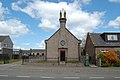
 Friockheim and Kinnell Parish Church - geograph.org.uk - 5517587.jpg 580 × 722; 58 KB
-
 Frost covered grass - geograph.org.uk - 1068629.jpg 640 × 555; 158 KB
-
 Frost covered grass, Bractullo Mill - geograph.org.uk - 1068636.jpg 640 × 452; 128 KB
-
 Garden at Dumbarrow Mill - geograph.org.uk - 6188794.jpg 5,184 × 3,888; 3.94 MB
-
 Gardyne Castle from East - geograph.org.uk - 3438075.jpg 1,024 × 768; 230 KB
-
 Gardyne Castle from North - geograph.org.uk - 3438079.jpg 768 × 1,024; 229 KB
-
 Gardyne Castle from North East - geograph.org.uk - 3438081.jpg 1,024 × 768; 204 KB
-
 Gardyne Castle from South West - geograph.org.uk - 3438077.jpg 1,024 × 576; 309 KB
-
 Gardyne Junction - geograph.org.uk - 2508919.jpg 3,456 × 2,304; 1.8 MB
-
 Gardyne Street, Friockheim - geograph.org.uk - 3609272.jpg 640 × 480; 240 KB
-
 Gardyne Street, Friockheim - geograph.org.uk - 5643429.jpg 640 × 480; 47 KB
-
 Gardyne Street, Friockheim - geograph.org.uk - 5643436.jpg 640 × 480; 69 KB
-
 Gask Farm - geograph.org.uk - 6587958.jpg 1,024 × 720; 169 KB
-
 Grain silos, West Mains of Gardyne - geograph.org.uk - 5172199.jpg 1,024 × 768; 284 KB
-
 Graveyard and former Church, Kirkden - geograph.org.uk - 3760046.jpg 1,024 × 684; 135 KB
-
 Harvested field, Kinneries - geograph.org.uk - 5906889.jpg 1,024 × 683; 286 KB
-
 Hillhead - geograph.org.uk - 5903545.jpg 1,024 × 683; 359 KB
-
 Horses at Fallady Bank - geograph.org.uk - 6188779.jpg 5,184 × 3,888; 6.9 MB
-
 House of Pitmuies - geograph.org.uk - 1832572.jpg 640 × 480; 42 KB
-
 House of Pitmuies - geograph.org.uk - 1981467.jpg 640 × 480; 207 KB
-
 Houses at Pressock - geograph.org.uk - 6188784.jpg 5,184 × 3,888; 5.4 MB
-

-
 Kirkshed, Idvies - geograph.org.uk - 3760096.jpg 1,024 × 683; 187 KB
-
 Long straight road - geograph.org.uk - 5171975.jpg 1,024 × 768; 311 KB
-
 Lunan Water - geograph.org.uk - 4540037.jpg 800 × 533; 458 KB
-
 Mains of Gardyne - geograph.org.uk - 5171997.jpg 1,024 × 768; 342 KB
-
 Masonic Lodge, Friockheim, Angus - geograph.org.uk - 3003540.jpg 3,008 × 2,000; 2.62 MB
-
 Minor road near Dumbarrow - geograph.org.uk - 3232672.jpg 1,200 × 797; 530 KB
-
 Minor road near Dumbarrow Mill - geograph.org.uk - 3232673.jpg 1,200 × 797; 791 KB
-
 Minor road near Dumbarrow Mill - geograph.org.uk - 3232677.jpg 1,200 × 797; 736 KB
-
 Minor road near Gask - geograph.org.uk - 3232534.jpg 1,200 × 797; 527 KB
-
 Minor road near Gask - geograph.org.uk - 3232535.jpg 1,200 × 797; 490 KB
-
 Minor road near Idvies Mill - geograph.org.uk - 3232698.jpg 1,200 × 797; 440 KB
-
 Minor road near Letham - geograph.org.uk - 3232704.jpg 1,200 × 797; 401 KB
-
 Minor road near Pressock - geograph.org.uk - 3232694.jpg 1,200 × 797; 430 KB
-
 Narrow minor road near Smithyton - geograph.org.uk - 6188791.jpg 5,184 × 3,888; 3.61 MB
-
 Near Idvies Mill - geograph.org.uk - 5171970.jpg 1,024 × 768; 435 KB
-
 Newly tilled field, Gardyne - geograph.org.uk - 5173107.jpg 1,024 × 768; 351 KB
-
 Newton of Idvies Farm - geograph.org.uk - 6588870.jpg 1,024 × 683; 113 KB
-
 Old troughs - geograph.org.uk - 5906897.jpg 1,024 × 683; 426 KB
-
 Ornamental Pond, Pitmuies Gardens - geograph.org.uk - 1832584.jpg 640 × 480; 77 KB
-
 Passion flower at Pitmuies - geograph.org.uk - 1981471.jpg 640 × 480; 147 KB
-

-
 Pitmuies Doo'cot - geograph.org.uk - 1981433.jpg 640 × 480; 305 KB
-
 Pitmuies Gardens - geograph.org.uk - 1443553.jpg 640 × 480; 152 KB
-
 Pitmuies Gardens - geograph.org.uk - 1832582.jpg 640 × 480; 118 KB
-

-
 Pond - geograph.org.uk - 1443579.jpg 640 × 480; 130 KB
-
 Potatoes, Hillhead - geograph.org.uk - 5903550.jpg 1,024 × 683; 335 KB
-
 Pressock Buildings - geograph.org.uk - 2508933.jpg 3,456 × 2,304; 1.48 MB
-
 Red Gate by Muirpark - geograph.org.uk - 2508874.jpg 3,456 × 2,304; 1.07 MB
-
 Road at Dumbarrow - geograph.org.uk - 6188798.jpg 5,184 × 3,888; 6.42 MB
-
 Road junction by Pressock - geograph.org.uk - 5171986.jpg 1,024 × 768; 309 KB
-
 Road junction near Gardyne - geograph.org.uk - 3232689.jpg 1,200 × 797; 618 KB
-
 Road junction near Letham - geograph.org.uk - 3232701.jpg 1,200 × 797; 423 KB
-
 Road junction near Muirpark Wood - geograph.org.uk - 3232455.jpg 1,200 × 797; 343 KB
-
 Road near Bractullo - geograph.org.uk - 3232529.jpg 1,200 × 797; 470 KB
-
 Road near Bractullo Mill - geograph.org.uk - 3232524.jpg 1,200 × 797; 369 KB
-
 Road near Bractullo Mill - geograph.org.uk - 3232527.jpg 1,200 × 797; 318 KB
-
 Road past Fallady Bank - geograph.org.uk - 3232695.jpg 1,200 × 797; 323 KB
-
 Road past Newton of Idvies - geograph.org.uk - 3232545.jpg 1,200 × 797; 372 KB
-
 Road to Kinneries - geograph.org.uk - 5906893.jpg 1,024 × 683; 389 KB
-
 Seed drill, Dumbarrow Mains - geograph.org.uk - 5173118.jpg 1,024 × 768; 280 KB
-
 Shed, Gask - geograph.org.uk - 5903544.jpg 1,024 × 683; 324 KB
-

-
 Silos at West Mains of Gardyne - geograph.org.uk - 6188786.jpg 5,184 × 3,888; 5.43 MB
-
 Silos near Gardyne - geograph.org.uk - 3232690.jpg 1,200 × 797; 404 KB
-
 Street Scene, Friockhiem - geograph.org.uk - 1542467.jpg 640 × 480; 118 KB
-
 Stubble, Gask - geograph.org.uk - 5903537.jpg 1,024 × 683; 176 KB
-
 Stubble, Hillhead - geograph.org.uk - 5903539.jpg 1,024 × 683; 293 KB
-
 Stubble, Idvies - geograph.org.uk - 5903535.jpg 1,024 × 683; 343 KB
-
 The Denton Burn - geograph.org.uk - 5173111.jpg 1,024 × 768; 573 KB
-
 The Paper Shop, Friockheim - geograph.org.uk - 3609280.jpg 640 × 480; 252 KB
-
 The Rose Garden at House of Pitmuies - geograph.org.uk - 1981412.jpg 640 × 480; 244 KB
-
 The Star Inn - geograph.org.uk - 6394845.jpg 1,024 × 963; 177 KB
-
 The Star Inn, Friockheim - geograph.org.uk - 3997280.jpg 800 × 533; 99 KB
-
 The Vinny Garden, Pitmuies - geograph.org.uk - 1981446.jpg 480 × 640; 273 KB
-
 Unusual Hairstyle - geograph.org.uk - 1981420.jpg 480 × 640; 206 KB
-
 View of Denton Burn looking upstream - geograph.org.uk - 1178988.jpg 640 × 427; 97 KB
-

-
 View towards Letham - geograph.org.uk - 4538409.jpg 800 × 450; 303 KB
-
 West Idvies - geograph.org.uk - 6188803.jpg 5,184 × 3,888; 4.57 MB
-
 Wheat, Legaston - geograph.org.uk - 3609296.jpg 640 × 480; 314 KB
-
 Winter cereals, Dumbarrow - geograph.org.uk - 5173120.jpg 1,024 × 768; 321 KB
-
 Wood near Bractullo Mill - geograph.org.uk - 4538394.jpg 800 × 450; 299 KB
-
 Woodland near Dumbarrow Mill - geograph.org.uk - 5173115.jpg 1,024 × 768; 512 KB
-
 Woodland, Middleton Quarry - geograph.org.uk - 3609288.jpg 640 × 480; 367 KB
-
 Woodland, Pitmuies - geograph.org.uk - 3609251.jpg 640 × 480; 338 KB


