Category:Jüdisches Wohlfahrtszentrum (Köln)
Jump to navigation
Jump to search
| Object location | | View all coordinates using: OpenStreetMap |
|---|
 | |||||
| Upload media | |||||
| Instance of | |||||
|---|---|---|---|---|---|
| Location | Neuehrenfeld, Ehrenfeld, Cologne, Cologne Government Region, North Rhine-Westphalia, Germany | ||||
| Heritage designation | |||||
 | |||||
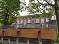
This is the category for an architectural monument.
It is on the list of cultural monuments of Köln, no. 7876.
It is on the list of cultural monuments of Köln, no. 7876.
Media in category "Jüdisches Wohlfahrtszentrum (Köln)"
The following 6 files are in this category, out of 6 total.
-
Der Wächter der Töpfe. Unterwegs mit dem Maschgiach in Köln.webm 8 min 28 s, 1,920 × 1,080; 122.04 MB
-
 Köln Ottostraße 85 (2).jpg 4,032 × 3,024; 5.12 MB
-
 Köln Ottostraße 85 (3).jpg 4,032 × 3,024; 5.8 MB
-
 Köln Ottostraße 85.jpg 4,032 × 3,024; 6.42 MB
-
 Wohlfahrtsszentrum ehrenfeld 20061203.jpg 1,000 × 585; 313 KB
-
 Wohlfahrtszentrum ehrenfeld.jpg 1,000 × 667; 299 KB
.jpg)
.jpg)

