Category:Inchkeith
Jump to navigation
Jump to search
island in the Firth of Forth, Scotland   | |||||
| Upload media | |||||
| Instance of | |||||
|---|---|---|---|---|---|
| Location |
| ||||
| Located in or next to body of water | |||||
| Area |
| ||||
 | |||||
Media in category "Inchkeith"
The following 58 files are in this category, out of 58 total.
-
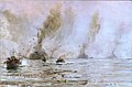 'Battle ships of German High Seas Fleet off Inch Keith' RMG PW1758.jpg 1,280 × 839; 964 KB
-
-

-

-
-
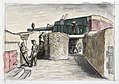
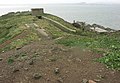
 Derelict gun emplacement on Inchkeith - geograph.org.uk - 926175.jpg 640 × 480; 107 KB
-
 Diving board - Pans Rocks - geograph.org.uk - 1098499.jpg 640 × 482; 32 KB
-
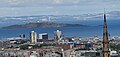
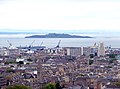
 Edinburgh view from the castle 03.JPG 2,676 × 1,724; 620 KB
-
 Edinburgh, UK - panoramio (211).jpg 1,600 × 1,200; 797 KB
-
 Hawkcraig Point - geograph.org.uk - 1099028.jpg 640 × 480; 77 KB
-
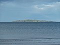
 Inchkeith (Fife) - geograph.org.uk - 387774.jpg 640 × 342; 37 KB
-
 Inchkeith - geograph.org.uk - 1016335.jpg 640 × 421; 52 KB
-
 Inchkeith - geograph.org.uk - 316654.jpg 640 × 424; 36 KB
-
 Inchkeith - geograph.org.uk - 903482.jpg 640 × 480; 43 KB
-
 Inchkeith and 'Safe Bristolia' - geograph.org.uk - 1045587.jpg 640 × 473; 53 KB
-

-
 Inchkeith from Arthur's Seat - geograph.org.uk - 3123523.jpg 1,390 × 946; 874 KB
-
 Inchkeith from Calton Hill.JPG 3,644 × 1,584; 3.21 MB
-
 Inchkeith from Edinburgh Castle - geograph.org.uk - 3118718.jpg 1,620 × 1,000; 1.3 MB
-
 Inchkeith from Edinburgh Castle - geograph.org.uk - 3512172.jpg 1,024 × 681; 90 KB
-
 Inchkeith from Edinburgh Castle.jpg 3,861 × 2,716; 3 MB
-
 Inchkeith from Kinghorn - geograph.org.uk - 815733.jpg 472 × 640; 88 KB
-
 Inchkeith from off Hound Point - geograph.org.uk - 5339622.jpg 1,024 × 262; 32 KB
-
 Inchkeith from Pettycur Bay - geograph.org.uk - 2674386.jpg 640 × 480; 41 KB
-
 Inchkeith from Pettycur Bay, Fife.JPG 2,546 × 1,317; 448 KB
-
 Inchkeith from Pettycur sands. - geograph.org.uk - 311710.jpg 640 × 480; 36 KB
-
 Inchkeith from the Binn - geograph.org.uk - 356980.jpg 640 × 480; 35 KB
-

-
 Inchkeith in the Firth of Forth - geograph.org.uk - 2674387.jpg 640 × 461; 40 KB
-
 Inchkeith Island - geograph.org.uk - 14269.jpg 640 × 480; 134 KB
-
 Inchkeith Island - geograph.org.uk - 14270.jpg 640 × 442; 141 KB
-
 Inchkeith Island - geograph.org.uk - 14271.jpg 640 × 456; 136 KB
-
 Inchkeith Island - geograph.org.uk - 71976.jpg 640 × 204; 143 KB
-
 Inchkeith Island from Portobello.jpg 2,256 × 1,112; 297 KB
-
 Inchkeith Island profile from West Wemyss - geograph.org.uk - 101588.jpg 640 × 438; 169 KB
-
 Inchkeith Island.jpg 640 × 462; 74 KB
-
 Inchkeith seen from the harbour - geograph.org.uk - 3314527.jpg 640 × 360; 81 KB
-
 Inchkeith.jpg 4,032 × 1,908; 2.2 MB
-
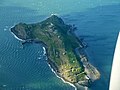
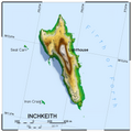 Inchkeith.png 4,320 × 4,320; 7.14 MB
-
 InchkeithJM.jpg 1,000 × 552; 46 KB
-
 Leith Harbour, Inchkeith - geograph.org.uk - 3323955.jpg 640 × 360; 99 KB
-
 Long Craig - geograph.org.uk - 1162555.jpg 409 × 640; 77 KB
-
 Lumpy little island - geograph.org.uk - 1162471.jpg 640 × 480; 47 KB
-
 Mortimer's Deep - geograph.org.uk - 1318548.jpg 640 × 477; 67 KB
-
 Ordnance Survey One-Inch Sheet 68 Firth of Forth, Published 1925.jpg 11,629 × 7,661; 9.4 MB
-
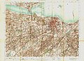 OS Sheet 32 Edinburgh Published 1904.jpg 11,043 × 8,113; 11.47 MB
-
 Pettycur pier, with Inchkeith Island beyond - geograph.org.uk - 1981243.jpg 1,600 × 1,204; 354 KB
-
 Sauchope road - geograph.org.uk - 870508.jpg 640 × 480; 71 KB
-
 Seal Carr - geograph.org.uk - 2707718.jpg 640 × 360; 258 KB
-

-
-

-

-
 The pier, Inchkeith - geograph.org.uk - 2707725.jpg 640 × 360; 238 KB
-
 Triangulation Pillar - geograph.org.uk - 666355.jpg 640 × 426; 51 KB
-
 View from Silverknowes to Inchkeith - geograph.org.uk - 3604628.jpg 1,024 × 681; 102 KB
-
 View of Edinburgh and Inchkeith.JPG 3,516 × 2,616; 4.64 MB
-
 View of north eastern Edinburgh.JPG 3,340 × 2,244; 4.42 MB

,_which_was_the_largest_number_of_works_concerning_a_single_subject_that_he_did_during_the_War._The_Art.IWMARTLD1272.jpg)
,_which_was_the_largest_number_of_works_concerning_a_single_subject_that_he_did_during_the_War._The_fortified_island_he_refers_to_in_these_wo_Art.IWMARTLD1267.jpg)
,_which_was_the_largest_number_of_works_concerning_a_single_subject_that_he_did_during_the_War._The_fortified_island_he_refers_to_in_these_wo_Art.IWMARTLD1271.jpg)
_-_panoramio.jpg)


.jpg)

_-_geograph.org.uk_-_387774.jpg)


.jpg)
.jpg)
.jpg)


