Category:How Stean Beck
Jump to navigation
Jump to search
English: How Stean Beck, or just Stean Beck, is a tributary of the River Nidd in Nidderdale (one of the Yorkshire Dales), North Yorkshire, England, United Kingdom. It forms the boundary between the parishes of Stonebeck Down and Stonebeck Up.
Media in category "How Stean Beck"
The following 8 files are in this category, out of 8 total.
-
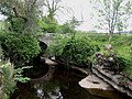
 Footbridge over How Stean Beck - geograph.org.uk - 1063771.jpg 1,024 × 683; 238 KB
-
 How Stean Beck - geograph.org.uk - 1202052.jpg 463 × 640; 114 KB
-
 How Stean Beck from Intake Lane - geograph.org.uk - 2716197.jpg 1,500 × 1,125; 1.02 MB
-
 How Stean Beck near Studfold Farm - geograph.org.uk - 458673.jpg 640 × 480; 136 KB
-
 How Stean Beck, Yorkshire - geograph.org.uk - 579809.jpg 640 × 536; 161 KB
-
 Meeting of the waters - geograph.org.uk - 573531.jpg 640 × 480; 170 KB
-
 Straight Stean Beck Ravine - geograph.org.uk - 495199.jpg 640 × 480; 89 KB
-
 Woods and How Stean Beck - geograph.org.uk - 1327.jpg 640 × 512; 103 KB


