Category:Hoton
Jump to navigation
Jump to search
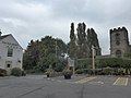
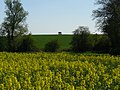
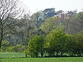
English: Hoton is a village and civil parish in the Charnwood district of Leicestershire, England. The parish has a population of around 350. It is on the A60, north-east of Loughborough. The village is just south of the border with Nottinghamshire. Nearby places are Prestwold (to the south), Wymeswold (to the east), and Rempstone (to the north, in Nottinghamshire).
village in the United Kingdom | |||||
| Upload media | |||||
| Instance of | |||||
|---|---|---|---|---|---|
| Location | Charnwood, Leicestershire, East Midlands, England | ||||
| Population |
| ||||
 | |||||
Subcategories
This category has only the following subcategory.
Media in category "Hoton"
The following 142 files are in this category, out of 142 total.
-
 1-5 Loughborough Road - geograph.org.uk - 2732063.jpg 1,280 × 954; 358 KB
-
 1-5 Loughborough Road - geograph.org.uk - 2734055.jpg 1,280 × 959; 202 KB
-
 14, Loughborough Road - geograph.org.uk - 2732058.jpg 1,280 × 959; 516 KB
-
 2 Loughborough Road, Hoton (geograph 7371770).jpg 1,024 × 768; 275 KB
-
 2, Loughborough Road - geograph.org.uk - 2732057.jpg 1,280 × 951; 466 KB
-
 20 and 22 Loughborough Road - geograph.org.uk - 2732059.jpg 1,280 × 959; 415 KB
-
 28 Wymeswold Road - geograph.org.uk - 750258.jpg 480 × 640; 170 KB
-
 28 Wymeswold Road, Hoton (geograph 7371752).jpg 1,024 × 768; 204 KB
-
 3 Wymeswold Road - geograph.org.uk - 2734051.jpg 1,280 × 959; 282 KB
-
 3 Wymeswold Road, Hoton (geograph 7370775).jpg 1,024 × 768; 139 KB
-
 5-11 Wymeswold Road (2) - geograph.org.uk - 2734050.jpg 1,280 × 959; 284 KB
-
 5-11 Wymeswold Road - geograph.org.uk - 2734046.jpg 1,280 × 959; 219 KB
-
 A60 at King's Bridge, south of Rempstone - geograph.org.uk - 4020264.jpg 1,024 × 768; 209 KB
-
 A60 Loughborough Road near Hoton - geograph.org.uk - 905761.jpg 640 × 447; 65 KB
-

-
 A60 Rempstone Road in Hoton - geograph.org.uk - 905729.jpg 640 × 387; 65 KB
-
 A60 towards Loughborough - geograph.org.uk - 3079449.jpg 640 × 480; 76 KB
-
 A60 towards Loughborough - geograph.org.uk - 3079462.jpg 640 × 480; 47 KB
-

-
 Barn at Holly Tree Farm, Hoton (geograph 7370780).jpg 1,024 × 769; 184 KB
-
 Black a moors Spinney - geograph.org.uk - 1293951.jpg 640 × 480; 161 KB
-
 Black a moors Spinney - geograph.org.uk - 1293955.jpg 640 × 480; 170 KB
-
 Brook Farm Court - geograph.org.uk - 750259.jpg 640 × 480; 167 KB
-
 Brookfield Farm - geograph.org.uk - 2733993.jpg 1,280 × 950; 531 KB
-
 Building group on Wymeswold Road - geograph.org.uk - 2734040.jpg 1,280 × 959; 285 KB
-
 Buildings at Harts Farm - geograph.org.uk - 5827386.jpg 640 × 434; 82 KB
-
 Buildings at Harts Farm - geograph.org.uk - 5827387.jpg 640 × 466; 85 KB
-
 Bus stop on Prestwold Road - geograph.org.uk - 6450815.jpg 1,024 × 768; 170 KB
-
 Camouflaged guardhouse - geograph.org.uk - 2734033.jpg 1,280 × 959; 415 KB
-
 Car park, Packe Arms - geograph.org.uk - 4167040.jpg 640 × 480; 58 KB
-

-
 Cotes.jpg 800 × 604; 104 KB
-
 Cottage on Old Parsonage Lane - geograph.org.uk - 2732066.jpg 1,280 × 959; 485 KB
-
 Cottages, Wymeswold Road, Hoton (geograph 7370729).jpg 1,024 × 768; 149 KB
-
 Cruck frame at 11 Wymeswold Road, Hoton (geograph 7371757).jpg 1,024 × 768; 152 KB
-

-
 Entrance to Hoton Park - geograph.org.uk - 6595078.jpg 768 × 1,024; 218 KB
-
 Entry to The Old Barn and Hoton Store - geograph.org.uk - 905711.jpg 640 × 461; 64 KB
-
 Farm buildings and Holts Lodge - geograph.org.uk - 2734031.jpg 1,280 × 959; 286 KB
-

-
 Farmland east of Stanford on Soar (1) - geograph.org.uk - 4230301.jpg 1,024 × 768; 141 KB
-
 Farmland east of Stanford on Soar (2) - geograph.org.uk - 4230305.jpg 1,024 × 768; 127 KB
-
 Farmland east of Stanford on Soar (3) - geograph.org.uk - 4230308.jpg 1,024 × 768; 149 KB
-
 Farmland east of Stanford on Soar (4) - geograph.org.uk - 4230312.jpg 1,024 × 768; 146 KB
-
 Farmland near Hoton - geograph.org.uk - 3079452.jpg 1,024 × 574; 101 KB
-
 Farmland off Loughborough Road - geograph.org.uk - 3079457.jpg 640 × 480; 66 KB
-
 Field edge path south of Stanford Hall - geograph.org.uk - 4230314.jpg 1,024 × 768; 182 KB
-
 Footpath alongside King's Brook - geograph.org.uk - 4017058.jpg 1,024 × 768; 172 KB
-
 Footpath and signs east of Stanford on Soar - geograph.org.uk - 4230313.jpg 1,024 × 768; 321 KB
-
 Footpath at Hoton - geograph.org.uk - 2732064.jpg 1,280 × 959; 548 KB
-
 From Hoton Hills to Stanfiord - geograph.org.uk - 1293996.jpg 640 × 480; 152 KB
-
 Ghostly control tower - geograph.org.uk - 2733996.jpg 959 × 1,280; 440 KB
-
 Gorse Farm - geograph.org.uk - 2734006.jpg 1,280 × 959; 387 KB
-
 Heat Haze Hoton - geograph.org.uk - 1293995.jpg 640 × 480; 106 KB
-
 Holly Tree farmhouse (2) - geograph.org.uk - 2734048.jpg 1,280 × 959; 452 KB
-
 Holly Tree farmhouse - geograph.org.uk - 2734047.jpg 1,280 × 959; 421 KB
-
 Holt's Lodge - geograph.org.uk - 2734019.jpg 1,280 × 959; 236 KB
-
 Holts Farmhouse - geograph.org.uk - 2734036.jpg 1,280 × 959; 326 KB
-
 Hoton church is now a private residence - geograph.org.uk - 4358467.jpg 2,592 × 1,944; 1.14 MB
-
 Hoton from the Hills - geograph.org.uk - 1294001.jpg 640 × 480; 88 KB
-
 Hoton from the Hills - geograph.org.uk - 1294012.jpg 640 × 480; 163 KB
-
 Hoton from the Sutcliffe Hills - geograph.org.uk - 1294366.jpg 640 × 480; 195 KB
-
 Hoton Hills Tree - geograph.org.uk - 1293991.jpg 640 × 480; 180 KB
-
 Hoton Hills Trees - geograph.org.uk - 1293769.jpg 640 × 480; 167 KB
-
 Hoton Hills Trees - geograph.org.uk - 1293890.jpg 640 × 480; 214 KB
-
 Hoton Hills Trees - geograph.org.uk - 1293893.jpg 640 × 480; 187 KB
-
 Hoton Hills Trees - geograph.org.uk - 1293930.jpg 640 × 480; 176 KB
-
 Hoton Hills Trees - geograph.org.uk - 1293936.jpg 640 × 480; 146 KB
-
 Hoton Hills Trees - geograph.org.uk - 1293938.jpg 640 × 480; 184 KB
-
 Hoton Hills Trees - geograph.org.uk - 1293949.jpg 640 × 480; 174 KB
-
 Hoton Hills Trees - geograph.org.uk - 1293997.jpg 640 × 480; 198 KB
-
 Hoton Hills Trees - geograph.org.uk - 1294007.jpg 640 × 480; 173 KB
-
 Hoton Hills Trees - geograph.org.uk - 1294009.jpg 480 × 640; 167 KB
-
 Hoton House - geograph.org.uk - 2734052.jpg 1,280 × 959; 304 KB
-
 Hoton Park sign - geograph.org.uk - 2734016.jpg 1,280 × 959; 405 KB
-
 Hoton Road - geograph.org.uk - 2734010.jpg 1,280 × 959; 444 KB
-
 Hoton Village Hall - geograph.org.uk - 15689.jpg 640 × 420; 119 KB
-
 Hoton Village Hall - geograph.org.uk - 750266.jpg 640 × 467; 152 KB
-

-
 Hoton, Leicestershire, former barn.jpg 1,280 × 959; 452 KB
-
 King's Brook fields - geograph.org.uk - 1293787.jpg 640 × 480; 149 KB
-
 King's Brook path - geograph.org.uk - 1293797.jpg 640 × 480; 203 KB
-
 King's Brook trees - geograph.org.uk - 1293758.jpg 640 × 480; 159 KB
-
 King's Brook west of Hoton - geograph.org.uk - 4017055.jpg 1,024 × 768; 183 KB
-
 Kings Bridge Notts Leics border - geograph.org.uk - 1294033.jpg 640 × 480; 170 KB
-
 Kings Bridge Notts Leics border - geograph.org.uk - 1294034.jpg 640 × 480; 166 KB
-
 Loughborough Road towards Cotes - geograph.org.uk - 5827383.jpg 640 × 433; 40 KB
-
 Loughborough Road towards Hoton - geograph.org.uk - 5827384.jpg 640 × 439; 49 KB
-
 Loughborough Road, Hoton - geograph.org.uk - 750272.jpg 640 × 465; 157 KB
-
 Near Hoton - geograph.org.uk - 1294046.jpg 640 × 480; 179 KB
-

-
-

-

-
 Near Stanford Hall - geograph.org.uk - 1293750.jpg 640 × 480; 161 KB
-
 Occupational Statistics for Hoton 1881.jpg 1,008 × 630; 48 KB
-
 Occupational Statistics for Hoton 2011.jpg 1,008 × 630; 57 KB
-
 Occupational Statistics Hoton 1881 (corrective).jpg 1,008 × 630; 64 KB
-
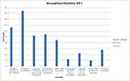 Occupational Statistics Hoton 2011 (corrective).jpg 1,008 × 630; 94 KB
-
 Old runway at Wymeswold - geograph.org.uk - 2734022.jpg 1,280 × 959; 337 KB
-
 Packe Arms - geograph.org.uk - 750283.jpg 640 × 452; 159 KB
-
 Packe Arms information board - geograph.org.uk - 750279.jpg 474 × 640; 190 KB
-
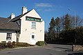 Packe Arms, Hoton - geograph.org.uk - 1741438.jpg 640 × 426; 63 KB
-
 Peartree Farmhouse - geograph.org.uk - 2732065.jpg 1,280 × 959; 432 KB
-
 Perimeter road, Wymeswold airfield - geograph.org.uk - 2733992.jpg 1,280 × 959; 523 KB
-
 Perimeter road, Wymeswold airfield - geograph.org.uk - 2734025.jpg 1,280 × 959; 296 KB
-
 Prestwold Lane into Prestwold - geograph.org.uk - 6769380.jpg 1,600 × 1,117; 160 KB
-
 RAF Wymeswold - geograph.org.uk - 2733998.jpg 1,280 × 827; 194 KB
-
 RAF Wymeswold - geograph.org.uk - 2734004.jpg 1,280 × 959; 421 KB
-
 RAF Wymeswold, control tower and water tank - geograph.org.uk - 2734000.jpg 1,280 × 959; 254 KB
-
 Rempstone Road towards Hoton - geograph.org.uk - 905759.jpg 640 × 393; 79 KB
-
 Roadway to New Covert Farm - geograph.org.uk - 4959387.jpg 1,024 × 768; 148 KB
-
 Scarecrow near Stanford on Soar - geograph.org.uk - 1293733.jpg 640 × 480; 160 KB
-
 Scarecrow near Stanford on Soar - geograph.org.uk - 1293739.jpg 640 × 480; 177 KB
-
 Scarecrow near Stanford on Soar - geograph.org.uk - 1293742.jpg 640 × 480; 274 KB
-
 Secret garden. - panoramio.jpg 2,592 × 1,944; 851 KB
-
-
 St Leonard's Church, Hoton - geograph.org.uk - 3079439.jpg 480 × 640; 77 KB
-
 Thatched Cottage, Hoton - geograph.org.uk - 15687.jpg 640 × 609; 194 KB
-
 The entrance to Hoton Park - geograph.org.uk - 2734012.jpg 1,280 × 959; 385 KB
-
 The lonely tree and the sky - geograph.org.uk - 748214.jpg 640 × 480; 102 KB
-
 The Packe Arms, Hoton - geograph.org.uk - 3079434.jpg 640 × 404; 52 KB
-
 Timber Framed House, Hoton - geograph.org.uk - 15686.jpg 640 × 440; 138 KB
-
 Trees lining Loughborough road - geograph.org.uk - 1294050.jpg 640 × 480; 178 KB
-
 Trees on King's Brook - geograph.org.uk - 1293780.jpg 640 × 480; 180 KB
-
 View from Hoton Hills - geograph.org.uk - 1294021.jpg 640 × 480; 172 KB
-
 View from Hoton Hills - geograph.org.uk - 750226.jpg 640 × 480; 172 KB
-
 View from Hoton Hills - geograph.org.uk - 750228.jpg 640 × 480; 199 KB
-
 View into South Nottinghamshire - geograph.org.uk - 905817.jpg 640 × 454; 112 KB
-
 View into South Nottinghamshire - geograph.org.uk - 905827.jpg 541 × 640; 123 KB
-
 View towards Hoton - geograph.org.uk - 905840.jpg 640 × 505; 104 KB
-
 Wymeswold Airfield - geograph.org.uk - 4905363.jpg 3,264 × 2,448; 4.26 MB
-
 Wymeswold Road heading east - geograph.org.uk - 3079443.jpg 640 × 480; 70 KB
-
 Wymeswold Road near Hoton - geograph.org.uk - 905720.jpg 640 × 480; 100 KB
-
 Wymeswold Road, Hoton - geograph.org.uk - 3079442.jpg 640 × 480; 66 KB
-
 Wymeswold Road, Hoton - geograph.org.uk - 750255.jpg 640 × 480; 171 KB
-
 Bridleway to Hoton Hills - geograph.org.uk - 750183.jpg 640 × 480; 201 KB
-
 Farm track leading to Hoton Hills - geograph.org.uk - 750181.jpg 640 × 469; 169 KB
-
 Footbridge over King's Brook - geograph.org.uk - 749128.jpg 480 × 640; 283 KB
-
 King's Brook - geograph.org.uk - 749132.jpg 480 × 640; 297 KB
-
 Ploughed field near Hoton - geograph.org.uk - 17758.jpg 640 × 480; 191 KB
-
 Vine Tree Terrace, Hoton - geograph.org.uk - 15921.jpg 529 × 640; 117 KB


.jpg)


.jpg)

.jpg)
_-_geograph.org.uk_-_2734050.jpg)


.jpg)


.jpg)
.jpg)


_off_Loughborough_Road_-_geograph.org.uk_-_3079459.jpg)
_-_geograph.org.uk_-_4230301.jpg)
_-_geograph.org.uk_-_4230305.jpg)
_-_geograph.org.uk_-_4230308.jpg)
_-_geograph.org.uk_-_4230312.jpg)


_-_geograph.org.uk_-_2734048.jpg)


.jpg)
.jpg)


