Category:Horsehay
Jump to navigation
Jump to search
English: Horsehay is a village on the western outskirts of Dawley, which, along with several other towns and villages, now forms part of the new town of Telford in Shropshire, England. Horsehay lies in the Dawley Hamlets parish, and on the northern edge of the Ironbridge Gorge area.
village in United Kingdom | |||||
| Upload media | |||||
| Instance of | |||||
|---|---|---|---|---|---|
| Location | Dawley Hamlets, Telford and Wrekin, Shropshire, West Midlands, England | ||||
 | |||||
Subcategories
This category has only the following subcategory.
H
Media in category "Horsehay"
The following 31 files are in this category, out of 31 total.
-

-
 All Labour in Vain, Horsehay - geograph.org.uk - 1307208.jpg 640 × 472; 64 KB
-
 Best Chippy for miles - so I'm told - geograph.org.uk - 706870.jpg 640 × 480; 89 KB
-
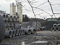 Concrete pipe factory - geograph.org.uk - 730579.jpg 640 × 480; 63 KB
-
 Dog in the Lane Junction - geograph.org.uk - 482571.jpg 640 × 480; 115 KB
-
 Dog in the Lane road sign - geograph.org.uk - 482575.jpg 640 × 480; 147 KB
-
 Doseley and its sleeping policemen - geograph.org.uk - 730576.jpg 640 × 480; 67 KB
-

-
 Forester Arms, Horsehay - geograph.org.uk - 1868409.jpg 640 × 480; 100 KB
-
 Horsehay Village Sign - geograph.org.uk - 4355599.jpg 640 × 490; 72 KB
-
 Lane near Huntington - geograph.org.uk - 729991.jpg 640 × 480; 97 KB
-
 Methodist Church - geograph.org.uk - 870873.jpg 640 × 480; 99 KB
-

-
 Wellington Road, Horsehay - geograph.org.uk - 1868420.jpg 640 × 480; 81 KB
-
 William Ball.jpg 2,353 × 3,407; 1.3 MB
-
 Another view of Coalmoor Lane - geograph.org.uk - 730013.jpg 640 × 480; 70 KB
-

-
 Cheshire Cheese, Doseley - geograph.org.uk - 138264.jpg 640 × 480; 67 KB
-
 Coalmoor Lane - geograph.org.uk - 730006.jpg 640 × 480; 81 KB
-
 Entrance to land-fill site - geograph.org.uk - 730562.jpg 640 × 480; 80 KB
-
 Farmhouse on the Huntington Road - geograph.org.uk - 482542.jpg 640 × 480; 126 KB
-
 Forester Arms, Horsehay - geograph.org.uk - 151197.jpg 640 × 480; 88 KB
-
 Gateway to a footpath - geograph.org.uk - 729959.jpg 640 × 480; 107 KB
-
 Horsehay - geograph.org.uk - 152200.jpg 640 × 480; 58 KB
-
 Horsehay Pool - geograph.org.uk - 161309.jpg 640 × 480; 78 KB
-
 Horsehay Village Golf Centre - geograph.org.uk - 152203.jpg 640 × 480; 48 KB
-
 Lane beside Lower Huntington Farm - geograph.org.uk - 730552.jpg 640 × 480; 72 KB
-
 Lydebrook (Loamhole) Dingle - geograph.org.uk - 161827.jpg 640 × 480; 145 KB
-
 Procter and Evans - geograph.org.uk - 152205.jpg 640 × 480; 58 KB
-
 Station Cafe - geograph.org.uk - 706873.jpg 640 × 480; 75 KB
-
 The Labour In Vain - geograph.org.uk - 152198.jpg 640 × 480; 55 KB


_Dingle_-_geograph.org.uk_-_161827.jpg)


