Category:Hatfield, East Riding of Yorkshire
Jump to navigation
Jump to search
civil parish in the East Riding of Yorkshire, England | |||||
| Upload media | |||||
| Instance of | |||||
|---|---|---|---|---|---|
| Location | East Riding of Yorkshire, Yorkshire and the Humber, England | ||||
| Population |
| ||||
 | |||||
Subcategories
This category has the following 4 subcategories, out of 4 total.
Media in category "Hatfield, East Riding of Yorkshire"
The following 200 files are in this category, out of 227 total.
(previous page) (next page)-
 A footpath crosses the rail trail - geograph.org.uk - 2099318.jpg 800 × 600; 387 KB
-
 A footpath near Great Hatfield - geograph.org.uk - 2199332.jpg 800 × 600; 270 KB
-
 A New Hedge - geograph.org.uk - 6111181.jpg 4,954 × 2,890; 1.87 MB
-

-
 A wet corner on Grundill Lane - geograph.org.uk - 3351695.jpg 4,000 × 3,000; 2.75 MB
-
 Access road from Stud Farm to minor road - geograph.org.uk - 4892828.jpg 1,024 × 768; 632 KB
-
 An icy Hornsea Rail Trail - geograph.org.uk - 4795313.jpg 640 × 480; 106 KB
-
 An icy Hornsea Rail Trail - geograph.org.uk - 4795402.jpg 640 × 491; 80 KB
-
 An icy Mappleton Road - geograph.org.uk - 4796558.jpg 640 × 480; 87 KB
-
 Ancient Cross, Great Hatfield - geograph.org.uk - 6108354.jpg 4,836 × 3,470; 2.72 MB
-
 Approaching junction with Eastfield Lane on the left - geograph.org.uk - 6675770.jpg 4,608 × 3,456; 4.1 MB
-
 Approaching Stud Farm - geograph.org.uk - 5690210.jpg 1,024 × 768; 216 KB
-
 Autumn sown crop - geograph.org.uk - 5603090.jpg 1,024 × 768; 127 KB
-
 Barns at Middle Farm - geograph.org.uk - 6112852.jpg 4,200 × 3,095; 2.16 MB
-
 Blue post - geograph.org.uk - 5603089.jpg 1,024 × 768; 312 KB
-
 Boundary marker - geograph.org.uk - 5597677.jpg 1,024 × 768; 310 KB
-
 Bridleway alongside Hatfield Wood - geograph.org.uk - 5597593.jpg 1,024 × 768; 285 KB
-
 Bridleway and Wind Turbine - geograph.org.uk - 5597692.jpg 1,024 × 768; 193 KB
-
 Bridleway at Great Hatfield - geograph.org.uk - 4867955.jpg 640 × 480; 440 KB
-
 Bridleway by Mount Pleasant - geograph.org.uk - 6685244.jpg 1,024 × 768; 272 KB
-
 Bridleway near Hatfield Grange - geograph.org.uk - 6426795.jpg 1,600 × 1,178; 407 KB
-
 Bridleway near Sigglesthorne Grange - geograph.org.uk - 1463703.jpg 640 × 480; 124 KB
-
 Bridleway to Cowden Lane - geograph.org.uk - 5597689.jpg 1,024 × 768; 169 KB
-
 Bridleway to Mappleton Road - geograph.org.uk - 5597683.jpg 1,024 × 768; 243 KB
-
 Bridleway to Wood Farm - geograph.org.uk - 5597591.jpg 1,024 × 768; 170 KB
-
 Bridleway toward Stud Farm - geograph.org.uk - 4892841.jpg 1,024 × 768; 523 KB
-
 Bridleway-drive near Sigglesthorne - geograph.org.uk - 5945240.jpg 794 × 1,024; 934 KB
-
 Cemetery, Great Hatfield - geograph.org.uk - 4867974.jpg 640 × 480; 533 KB
-
 Chalk on the track - geograph.org.uk - 6433989.jpg 5,292 × 3,240; 2.52 MB
-

-
 Clump of trees near Goxhill - geograph.org.uk - 5690274.jpg 1,024 × 768; 179 KB
-
 Copse sign, Great Hatfield - geograph.org.uk - 4867966.jpg 640 × 480; 528 KB
-
 Corner on Grundill Lane - geograph.org.uk - 3351696.jpg 4,000 × 3,000; 3.2 MB
-
 Crop field and woodland - geograph.org.uk - 4796572.jpg 640 × 480; 61 KB
-
 Crop field off Sigglesthorne Road - geograph.org.uk - 4796522.jpg 640 × 480; 82 KB
-

-
 Crop field. Mill Hill - geograph.org.uk - 4795306.jpg 640 × 480; 90 KB
-
 Cross Street, Great Hatfield - geograph.org.uk - 4867984.jpg 640 × 480; 358 KB
-
 Cross Street, Great Hatfield - geograph.org.uk - 6108356.jpg 5,152 × 3,470; 2.78 MB
-
 Cross, Great Hatfield - geograph.org.uk - 4796584.jpg 640 × 480; 87 KB
-
 Crossroads at Goxhill - geograph.org.uk - 6111217.jpg 4,301 × 2,437; 2.39 MB
-
 Daffodils at Great Hatfield - geograph.org.uk - 4867961.jpg 480 × 640; 569 KB
-

-
 Densholme Community Care Farm - geograph.org.uk - 6108890.jpg 1,600 × 1,152; 453 KB
-
 Disused Victorian postbox on Main Street, Great Hatfield - geograph.org.uk - 6362840.jpg 1,293 × 2,481; 571 KB
-
 Driveway to Stud Farm - geograph.org.uk - 5690213.jpg 1,024 × 768; 376 KB
-
 Dyke between Rise and Hatfield - geograph.org.uk - 4869393.jpg 480 × 640; 607 KB
-

-
 Embankment of a slurry lagoon - geograph.org.uk - 5597690.jpg 1,024 × 768; 198 KB
-
 Entering Great Hatfield - geograph.org.uk - 4796576.jpg 640 × 480; 94 KB
-
 Entering Great Hatfield, East Yorkshire - geograph.org.uk - 2566296.jpg 800 × 600; 297 KB
-
 Entrance to Manor Farm - geograph.org.uk - 5690449.jpg 1,024 × 768; 167 KB
-
 Entrance to Wood Farm - geograph.org.uk - 5597679.jpg 1,024 × 768; 208 KB
-
 Entrance to Wood Farm - geograph.org.uk - 6685261.jpg 1,024 × 768; 135 KB
-
 Farm track and cottage, Goxhill - geograph.org.uk - 5583380.jpg 1,024 × 768; 205 KB
-
 Farm track near Goxhill, E Yorks - geograph.org.uk - 5945243.jpg 1,024 × 829; 639 KB
-

-
 Farm track to Mount Pleasant - geograph.org.uk - 5597674.jpg 1,024 × 768; 164 KB
-
 Farmland near Little Hatfield - geograph.org.uk - 2704725.jpg 640 × 426; 173 KB
-
 Farmland north of Mappleton Road - geograph.org.uk - 4796561.jpg 640 × 480; 77 KB
-
 Farmland off the Transpennine Trail - geograph.org.uk - 4796533.jpg 640 × 480; 75 KB
-
 Farmland towards Manor Farm - geograph.org.uk - 4796534.jpg 640 × 480; 73 KB
-
 Field drain under minor road - geograph.org.uk - 4892809.jpg 1,024 × 768; 508 KB
-
 Field edge by the Stud Farm - geograph.org.uk - 6672095.jpg 1,024 × 768; 169 KB
-
 Folly Lane towards, Sigglesthorne - geograph.org.uk - 2746307.jpg 800 × 600; 93 KB
-
 Footpath to Great Hatfield - geograph.org.uk - 3361334.jpg 3,000 × 4,000; 4.26 MB
-
 Footpath to Mappleton Road - geograph.org.uk - 5597654.jpg 1,024 × 768; 274 KB
-
 Footpath to Mappleton Road - geograph.org.uk - 5597662.jpg 1,024 × 768; 299 KB
-
 Footpath to Wassand - geograph.org.uk - 5581081.jpg 1,024 × 768; 461 KB
-

-
 Gate into Stud Farm - geograph.org.uk - 5690466.jpg 1,024 × 768; 372 KB
-
 Goxhill House and farm - geograph.org.uk - 5690273.jpg 1,024 × 768; 160 KB
-
 Goxhill House Farm, Goxhill - geograph.org.uk - 2999487.jpg 640 × 480; 74 KB
-
 Grange Farm - geograph.org.uk - 4795322.jpg 640 × 463; 70 KB
-
 Grazing near Grange Farm - geograph.org.uk - 4795316.jpg 640 × 480; 87 KB
-
 Grazing near Grange Farm - geograph.org.uk - 4795326.jpg 640 × 459; 78 KB
-
 Grazing near Rowlands Farm - geograph.org.uk - 4796544.jpg 640 × 445; 67 KB
-
 Grazing near Rowlings Farm - geograph.org.uk - 4796508.jpg 640 × 480; 85 KB
-
 Great Hatfield Cross - geograph.org.uk - 6362842.jpg 800 × 600; 100 KB
-
 Great Hatfield Road - geograph.org.uk - 4869056.jpg 640 × 480; 376 KB
-
 Green Lane - geograph.org.uk - 5690215.jpg 1,024 × 768; 256 KB
-
 Harvesting near West Close Farm - geograph.org.uk - 2566287.jpg 800 × 600; 189 KB
-
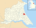 Hatfield, East Riding of Yorkshire UK parish locator map.svg 1,425 × 1,107; 1.68 MB
-
 Heading north from Great Hatfield - geograph.org.uk - 4796551.jpg 640 × 480; 95 KB
-

-
 Holderness landscape - geograph.org.uk - 5690455.jpg 1,024 × 768; 177 KB
-
 Hornsea Rail Trail - geograph.org.uk - 4795333.jpg 640 × 522; 131 KB
-
 Hornsea Rail Trail - geograph.org.uk - 4795378.jpg 640 × 480; 113 KB
-
 Hornsea Rail Trail - geograph.org.uk - 4796529.jpg 640 × 480; 88 KB
-
 Hornsea Rail Trail - geograph.org.uk - 6256695.jpg 1,024 × 768; 307 KB
-
 Hornsea Rail Trail - geograph.org.uk - 6434063.jpg 5,472 × 3,648; 3.52 MB
-
 Hornsea Rail Trail at Great Hatfield - geograph.org.uk - 6108447.jpg 5,074 × 3,481; 2.72 MB
-
 Hornsea Rail Trail near Grange Farm - geograph.org.uk - 4795321.jpg 640 × 480; 120 KB
-
 Hornsea Rail Trail near Great Hatfield - geograph.org.uk - 4868951.jpg 480 × 640; 482 KB
-
 Hornsea Rail Trail near Rowlings Farm - geograph.org.uk - 4796506.jpg 640 × 480; 119 KB
-
 Hornsea Rail Trail Signpost, Goxhill - geograph.org.uk - 3059628.jpg 3,072 × 2,304; 1.8 MB
-
 Hornsea Rail Trail ^19 - geograph.org.uk - 5024184.jpg 640 × 480; 110 KB
-
 Hornsea Rail Trail ^20 - geograph.org.uk - 5024185.jpg 640 × 480; 105 KB
-
 Hornsea Rail Trail ^21 - geograph.org.uk - 5024186.jpg 640 × 480; 146 KB
-
 Hornsea Rail Trail ^22 - geograph.org.uk - 5024187.jpg 640 × 480; 165 KB
-
 Hornsea Rail Trail ^22 - geograph.org.uk - 5024188.jpg 640 × 480; 124 KB
-
 Hornsea Road, near Great Hatfield - geograph.org.uk - 4868899.jpg 640 × 480; 295 KB
-
 Horses Keep To Road - geograph.org.uk - 6111232.jpg 1,600 × 1,067; 543 KB
-

-

-

-

-
 Housing at Little Hatfield - geograph.org.uk - 6112848.jpg 5,472 × 3,648; 2.45 MB
-
 Hull Road, Great Hatfield - geograph.org.uk - 4796542.jpg 640 × 480; 88 KB
-
 Hull To Hornsea line that was - geograph.org.uk - 1807696.jpg 4,000 × 3,000; 5.67 MB
-
 Knowles Field - geograph.org.uk - 4796614.jpg 640 × 480; 69 KB
-
 Land at Wood Farm - geograph.org.uk - 6426816.jpg 5,055 × 3,047; 2.42 MB
-
 Lane near Rolston - geograph.org.uk - 4868933.jpg 640 × 480; 405 KB
-
 Lane toward West Close Farm - geograph.org.uk - 6675766.jpg 4,608 × 3,456; 3.77 MB
-
 Line of trees along Mappleton Road - geograph.org.uk - 5597587.jpg 1,024 × 768; 151 KB
-
 Looking east along Main Street Great Hatfield - geograph.org.uk - 4320631.jpg 4,570 × 3,406; 4.54 MB
-
 Looking south from the hamlet of Goxhill, East Yorkshire - geograph.org.uk - 6504772.jpg 2,048 × 1,536; 672 KB
-
 Looking towards Grange Farm - geograph.org.uk - 6256706.jpg 1,024 × 768; 193 KB
-
 Looking West down Eastfield Lane - geograph.org.uk - 2099078.jpg 800 × 600; 250 KB
-
 Main Street, Great Hatfield - geograph.org.uk - 6362974.jpg 4,693 × 3,298; 3.18 MB
-
 Manor Farm - geograph.org.uk - 6256686.jpg 1,024 × 768; 196 KB
-
 Manor Farm Cottages in the rain - geograph.org.uk - 4968975.jpg 4,606 × 3,454; 5.28 MB
-
 Mappleton Road - geograph.org.uk - 4796569.jpg 640 × 480; 88 KB
-
 Mappleton Road - geograph.org.uk - 5597671.jpg 1,024 × 768; 233 KB
-
 Mappleton Road - geograph.org.uk - 6685257.jpg 1,024 × 768; 157 KB
-
 Mappleton Road at Great Hatfield - geograph.org.uk - 6107267.jpg 4,485 × 3,286; 1.81 MB
-
 Mappleton Water Tower - geograph.org.uk - 4868919.jpg 480 × 640; 371 KB
-
 Medieval Cross east end of Great Hatfield - geograph.org.uk - 4320595.jpg 4,608 × 3,456; 5.73 MB
-
 Middle Farm - geograph.org.uk - 5603052.jpg 1,024 × 768; 153 KB
-
 Middle Farm, Little Hatfield - geograph.org.uk - 4869066.jpg 640 × 484; 483 KB
-
 Minor road towards Goxhill - geograph.org.uk - 4795401.jpg 640 × 429; 62 KB
-
 Minor road towards Goxhill - geograph.org.uk - 4892817.jpg 1,024 × 766; 356 KB
-
 Minor road towards Sigglesthorne - geograph.org.uk - 4795359.jpg 640 × 480; 69 KB
-
 Morning Sunshine, Mappleton Road - geograph.org.uk - 6107272.jpg 5,472 × 3,648; 2.49 MB
-
 Mount Pleasant - geograph.org.uk - 6426809.jpg 3,565 × 2,003; 1.09 MB
-
 Mount Pleasant Farm - geograph.org.uk - 5597659.jpg 1,024 × 761; 203 KB
-
 Near West Close Farm - geograph.org.uk - 4674262.jpg 1,024 × 768; 207 KB
-
 New hedging and water tower - geograph.org.uk - 5690221.jpg 1,024 × 768; 197 KB
-
 New hedging near Grange Farm - geograph.org.uk - 5690219.jpg 1,024 × 768; 192 KB
-
 New plantation and verge - geograph.org.uk - 5597586.jpg 1,024 × 768; 208 KB
-
 North Road, Great Hatfield - geograph.org.uk - 4796548.jpg 640 × 480; 88 KB
-
 Oak Tree Farm - geograph.org.uk - 5690451.jpg 1,024 × 768; 267 KB
-
 Oak Tree Farm near Goxhill - geograph.org.uk - 2099114.jpg 800 × 600; 304 KB
-
 Once a rail line now an overgrown bog - geograph.org.uk - 3361328.jpg 4,000 × 3,000; 4.97 MB
-
 Over fields to Manor Farm from Hornsea Rail Trail - geograph.org.uk - 6675505.jpg 4,608 × 3,456; 2.99 MB
-
 Path to Hatfield Grange - geograph.org.uk - 6685255.jpg 1,024 × 768; 102 KB
-
 Phone Box and Memorial, Great Hatfield - geograph.org.uk - 6108353.jpg 4,474 × 3,096; 1.76 MB
-
 Plantation by Mappleton Road - geograph.org.uk - 5597590.jpg 1,024 × 768; 150 KB
-
 Poles in a ploughed field near Goxhill - geograph.org.uk - 5581076.jpg 1,024 × 768; 192 KB
-
 Pond and trees in the middle of arable field - geograph.org.uk - 6675757.jpg 4,608 × 3,456; 3.58 MB
-
 Pond at Goxhill - geograph.org.uk - 1807714.jpg 4,000 × 3,000; 3.84 MB
-
 Pond at Goxhill - geograph.org.uk - 6107897.jpg 1,600 × 1,032; 665 KB
-
 Pond at Great Hatfield - geograph.org.uk - 6108873.jpg 5,036 × 3,432; 3.32 MB
-
 Pond, Great Hatfield - geograph.org.uk - 4796553.jpg 640 × 480; 103 KB
-
 Primroses in Hatfield Wood - geograph.org.uk - 6426895.jpg 4,851 × 3,175; 4.12 MB
-
 Rail Trail at Wassand Low Crossing - geograph.org.uk - 6111178.jpg 4,360 × 3,142; 2.15 MB
-
 Road to Goxhill - geograph.org.uk - 6108880.jpg 1,600 × 1,073; 566 KB
-
 Road to Little Hatfield - geograph.org.uk - 6121868.jpg 4,709 × 3,482; 1.32 MB
-
 Road to Wood Farm off Mappleton Road - geograph.org.uk - 6107244.jpg 1,600 × 1,032; 314 KB
-
 Roadway to Manor Farm - geograph.org.uk - 5603092.jpg 1,024 × 768; 132 KB
-
 Rowlings Farm - geograph.org.uk - 4795411.jpg 640 × 480; 65 KB
-
 Rowlings Farm, near Great Hatfield - geograph.org.uk - 2707255.jpg 640 × 446; 225 KB
-
 Sigglesthorne Road - geograph.org.uk - 4796520.jpg 640 × 480; 79 KB
-
 Sigglesthorne Road - geograph.org.uk - 5026896.jpg 640 × 480; 100 KB
-
 Sigglesthorne Road - geograph.org.uk - 6256689.jpg 1,024 × 768; 162 KB
-
 Sigglesthorne Road - geograph.org.uk - 6256692.jpg 1,024 × 768; 184 KB
-
 Sigglesthorne Road Great Hatfield - geograph.org.uk - 3361298.jpg 4,000 × 3,000; 2.85 MB
-

-

-

-
 Signpost with a Garland - geograph.org.uk - 6108427.jpg 4,868 × 3,084; 2.73 MB
-

-
 Slurry lagoon - geograph.org.uk - 5597696.jpg 1,024 × 768; 222 KB
-
 Slurry Pond - geograph.org.uk - 6685265.jpg 1,024 × 768; 205 KB
-
 Small Roadside Pond at Great Hatfield - geograph.org.uk - 6424322.jpg 4,608 × 3,456; 7.5 MB
-
 St Giles Church Goxhill - geograph.org.uk - 1807718.jpg 4,000 × 3,000; 3.75 MB
-
 St Giles Goxhill - geograph.org.uk - 4892695.jpg 1,024 × 768; 413 KB
-
 St Giles Goxhill Bench Mark under window - geograph.org.uk - 4892688.jpg 768 × 1,024; 506 KB
-
 St. Giles' church, Goxhill - geograph.org.uk - 5583315.jpg 1,024 × 768; 251 KB
-

-

-

-
 Stacks of plastic wrapped bales - geograph.org.uk - 5690459.jpg 1,024 × 768; 206 KB
-

-
 Stone cross, Great Hatfield - geograph.org.uk - 4867992.jpg 480 × 640; 496 KB
-
 Stream Dike, near Little Hatfield - geograph.org.uk - 4868973.jpg 480 × 640; 600 KB
-
 Stubble field near Great Hatfield - geograph.org.uk - 5597619.jpg 1,024 × 768; 201 KB
-
 Stud Farm - geograph.org.uk - 5690463.jpg 1,024 × 768; 327 KB
-
 Stud Farm entrance - geograph.org.uk - 6672079.jpg 1,024 × 768; 128 KB
-
 The 'In' Joke on the Tour de Yorkshire - geograph.org.uk - 5762445.jpg 3,183 × 1,994; 1.31 MB
-

-
 The churchyard wall and gates, Goxhill - geograph.org.uk - 5583387.jpg 1,024 × 768; 317 KB
-
 The Holderness Plain from the Hornsea Rail Trail - geograph.org.uk - 6675494.jpg 4,608 × 3,456; 3.84 MB
-
 The Hornsea Rail Trail - geograph.org.uk - 5597618.jpg 1,024 × 768; 176 KB
-
 The old school, Great Hatfield - geograph.org.uk - 2566317.jpg 800 × 600; 304 KB
-
 The Road from Great Hatfield to Hornsea - geograph.org.uk - 6424326.jpg 4,608 × 3,456; 7.62 MB
-
 The Road to Mappleton - geograph.org.uk - 6424339.jpg 3,111 × 1,800; 2.42 MB
-
 The track to Stud Farm - geograph.org.uk - 2099109.jpg 800 × 600; 303 KB
-

-
 The way to Manor Farm - geograph.org.uk - 2099297.jpg 800 × 600; 254 KB


