Category:Geological maps of the Mediterranean Sea
Jump to navigation
Jump to search
Media in category "Geological maps of the Mediterranean Sea"
The following 27 files are in this category, out of 27 total.
-
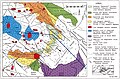 CentralMediterranean-GeotectonicMap.jpg 9,451 × 6,203; 20.29 MB
-
Crisis salina del Messiniense.ogv 1 min 14 s, 1,440 × 1,080; 18.21 MB
-
 Etapa2.jpg 3,246 × 2,195; 6.66 MB
-
 Etapa3.jpg 3,231 × 2,107; 5.93 MB
-
 Etapa3muda.jpg 3,246 × 2,195; 6.71 MB
-
 Etapa4.jpg 3,242 × 2,181; 5.69 MB
-
 Etapa4muda.jpg 3,246 × 2,195; 6.76 MB
-
 Hellenic arc.png 931 × 763; 840 KB
-
 Iberian Tectonic EN.svg 382 × 485; 695 KB
-
 Inserciomamifers.jpg 3,246 × 2,192; 1.92 MB
-
 Insercióinundacio.jpg 3,246 × 2,195; 1.85 MB
-
 Italia Interazione placche tettoniche.JPG 548 × 530; 240 KB
-
 Mar Mediterranèa - Tectonica generala.png 1,762 × 804; 515 KB
-
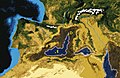
 Messinian Mediterranean and Gibraltar - reconstructed landscape.jpg 1,024 × 768; 570 KB
-
 Messinian palaeogeography.svg 423 × 501; 24 KB
-
 Messinian salinity crisis 5.3 mya stage - flooding.jpg 3,246 × 2,195; 4.09 MB
-
 Messinian salinity crisis 5.96 mya stage - drying.jpg 3,246 × 2,192; 4.06 MB
-
 Messinian salinity crisis 6 mya stage - last canal.jpg 3,246 × 2,196; 2 MB
-
 Messinian salinity crisis 6.5 mya stage.jpg 3,246 × 2,195; 6.7 MB
-
 Pllaka tektonike.png 597 × 263; 146 KB
-
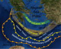
 Southern aegean volcanic arc.jpg 2,762 × 2,921; 1.59 MB
-
 Tectonic map Mediterranean DE.svg 1,280 × 715; 622 KB
-
 Tectonic map Mediterranean EN.svg 1,280 × 715; 623 KB
-
 Tectonic map Mediterranean FR.svg 1,280 × 715; 620 KB
-
 Tectonic map Mediterranean He.jpg 1,324 × 770; 218 KB
-
 Tectonic map Mediterranean MK.svg 1,280 × 715; 786 KB
-
 Tectonic map Mediterranean UK.svg 1,280 × 715; 608 KB


