Category:Geography of Alpine County, California
Jump to navigation
Jump to search
Counties of California: Alameda · Alpine · Amador · Butte · Calaveras · Colusa · Contra Costa · Del Norte · El Dorado · Fresno · Glenn · Humboldt · Imperial · Inyo · Kern · Kings · Lake · Lassen · Los Angeles · Madera · Marin · Mariposa · Mendocino · Merced · Modoc · Mono · Monterey · Napa · Nevada · Orange · Placer · Plumas · Riverside · Sacramento · San Benito · San Bernardino · San Diego · San Joaquin · San Luis Obispo · San Mateo · Santa Barbara · Santa Clara · Santa Cruz · Shasta · Sierra · Siskiyou · Solano · Sonoma · Stanislaus ·Sutter · Tehama · Trinity · Tulare · Tuolumne · Ventura · Yolo · Yuba – Consolidated city-county: San Francisco
- Geography of Alpine County — in the Eastern Sierra and Great Basin regions, eastern California.
Wikimedia category | |||||
| Upload media | |||||
| Instance of | |||||
|---|---|---|---|---|---|
| Category combines topics | |||||
| Alpine County | |||||
county in California, United States  Граница округа    | |||||
| Instance of | |||||
| Named after | |||||
| Location | California, Pacific States Region | ||||
| Capital | |||||
| Inception |
| ||||
| Population |
| ||||
| Area |
| ||||
| Different from | |||||
| official website | |||||
 | |||||
Subcategories
This category has the following 12 subcategories, out of 12 total.
Media in category "Geography of Alpine County, California"
The following 22 files are in this category, out of 22 total.
-
 Back of Round Top from end of Summit City Canyon - panoramio.jpg 2,560 × 1,920; 1.53 MB
-
 California fish and game (20520178441).jpg 1,626 × 2,308; 365 KB
-
 East of Upper Blue Lake - panoramio.jpg 1,824 × 1,368; 750 KB
-
 Fourth of July Lake, Alpine County.jpg 3,938 × 2,952; 4.24 MB
-
 Highland Peak, Sierra Nevada Range, Alpine County, California (21384522330).jpg 4,000 × 3,000; 4.43 MB
-
 Jobs Peak (155877704).jpg 600 × 450; 49 KB
-
 JobsPeak.jpg 1,024 × 768; 53 KB
-
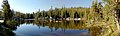
 Lower Sunset Lake - panoramio.jpg 1,152 × 864; 414 KB
-
 Panorama of Lower Mosquito Lake.jpg 3,324 × 1,000; 824 KB
-
 A skier heading towards RoundTop Peak.JPG 1,534 × 1,090; 703 KB
-
 Cressent Couloir shot from the summit of Round Top Peak.JPG 1,224 × 1,632; 612 KB
-
 Silver Mountain 04.jpg 4,928 × 2,772; 11.21 MB
-
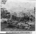 Silver Mountain Peak; altitude 11,000 feet; Alpine County LCCN2002723004.jpg 1,536 × 1,454; 317 KB
-
 Silver Mountain Peak; altitude 11,000 feet; Alpine County LCCN2002723004.tif 1,536 × 1,454; 2.13 MB
-
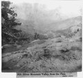
 Silver Mountain Valley, from the Pass, Alpine County LCCN2002723005.jpg 1,536 × 1,448; 320 KB
-
 Silver Mountain Valley, from the Pass, Alpine County LCCN2002723005.tif 1,536 × 1,448; 2.12 MB
-
 Utica Reservoir Campsite.jpg 8,064 × 2,518; 8.51 MB
-
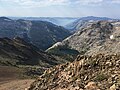
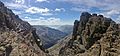
 View from Round Top Trail, Alpine County.jpg 5,520 × 2,528; 7.09 MB
-
 View from Round Top, Alpine County 2.jpg 5,440 × 2,530; 6.89 MB
-

-

-
 Winnemucca Lake, Alpine County.jpg 3,264 × 2,448; 4.08 MB

.jpg)


.jpg)
.jpg)


