Category:Ethnographic maps of the Balkans
Jump to navigation
Jump to search
Subcategories
This category has the following 13 subcategories, out of 13 total.
*
A
B
C
G
K
M
N
R
S
T
Media in category "Ethnographic maps of the Balkans"
The following 44 files are in this category, out of 44 total.
-

-

-
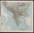
 1877 - Ethnological map of European Turkey and Greece.tif 4,210 × 5,059; 50.34 MB
-
 1916 Diagrammatic Map of Slav Territories East of the Adriatic.jpg 5,000 × 4,671; 4.36 MB
-
 Balkanhalbinsel BV042762526.jpg 8,452 × 8,219; 6.4 MB
-
 Balkanhalbinsel BV042762715.jpg 8,405 × 8,219; 5.84 MB
-
 AlbaniansOutsideAlbania.png 1,237 × 1,167; 284 KB
-
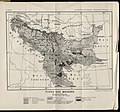
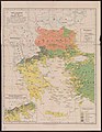
 Altserbien-und-Makedonien-map.jpg 2,829 × 1,385; 893 KB
-
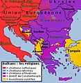 AtlBalk2010relig.jpg 318 × 327; 177 KB
-
 Balkanhalbinsel BV042762172.jpg 4,467 × 4,098; 2.38 MB
-
 Balkanhalbinsel BV042762278.jpg 4,350 × 3,996; 2.15 MB
-
 Balkanhalbinsel BV042762400.jpg 4,299 × 3,999; 2.08 MB
-
 Balkans ethnic map (1992).jpg 1,639 × 1,456; 252 KB
-

-
 Carte ethnographique de la Macédoine du Sud 1912.jpg 5,000 × 2,048; 7.46 MB
-
 Carte ethnographique de la Macédoine grecque août 1915.jpg 22,171 × 10,787; 44.24 MB
-
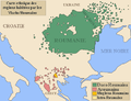
 Copy of Map-balkans-vlachs.png 500 × 331; 117 KB
-
 Ct002411.jpg 8,650 × 6,843; 43.36 MB
-
 Ethnicgroups.png 400 × 400; 62 KB
-
 Ethnographic Map of Macedonia, 1899.jpg 1,754 × 1,357; 905 KB
-
 Ethnographic Map of the Balkan Peninsula WDL93.png 1,194 × 1,024; 2.19 MB
-
 Ethnographic Map Of The Balkan Peninsula.png 11,974 × 15,688; 121.87 MB
-

-
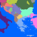
 Ethnographic map of the Balkans.png 3,931 × 3,931; 1.84 MB
-
 Ethnographic map of the central Balkans, ca. 1900) (cropped).png 1,196 × 1,465; 2.99 MB
-
 Ethnographic map of the central Balkans, ca. 1900.png 1,720 × 1,859; 6.42 MB
-
 Ethnographic-map-of-the-Balkans-1918.jpg 4,414 × 3,783; 3.25 MB
-
 Etnička karta-JI Evropa.gif 624 × 588; 43 KB
-
 Fr-carte-balkans-vlachs.png 440 × 337; 44 KB
-
-
 Hellenism in the Near East Ethnological Map of Greece by George Soteriadis c1918.jpg 7,453 × 9,144; 18.42 MB
-
 Jovan Cvijic 1918 Zones of civilization of the Balkan peninsula.tif 1,482 × 1,238; 5.28 MB
-
 Le Pays Šops.jpg 743 × 844; 99 KB
-
 Macedonians on a french.rev.jpg 1,730 × 1,566; 847 KB
-
 Map-balkans-vlachs-HE.png 440 × 337; 55 KB
-
 Map-balkans-vlachs.png 440 × 337; 71 KB
-
 Moldavané.png 440 × 337; 55 KB
-
 SE Europe Romanians.png 740 × 996; 162 KB
-
 SerbsInBalkans.png 1,694 × 1,480; 469 KB
-
 Untitled27 Restored 20240217195451.png 4,960 × 5,060; 5.01 MB
-
 Vlasimapa-sr.png 440 × 337; 32 KB
-
 VolkBalk-1908.jpg 1,352 × 1,380; 931 KB
-

-
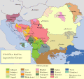
 BASA-176K-2-804-87-Etnographical map of the Southern Slavs, 1913.JPG 5,749 × 3,584; 11.89 MB


.jpg)


_-_Historische_alte_Landkarte_(Sammlerst%C3%BCck)_von_1924.jpg)

_(cropped).png)


