English: The
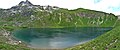
Engeratsgundsee (1876 m) is a lake in the
Allgäu Alps (Bavaria, Germany).
<nowiki>Engeratsgundsee; Engeratsgundsee; Engeratsgundsee; Engeratsgundsee; Engeratsgundsee; Engeratsgundsee; Engeratsgundsee; Engeratsgundsee; Engeratsgundsee; Engeratsgundsee; Engeratsgundsee; Engeratsgundsee; Engeratsgundsee; Engeratsgundsee; Engeratsgundsee; Engeratsgundsee; Engeratsgundsee; Engeratsgundsee; Engeratsgundsee; Engeratsgundsee; Engeratsgundsee; Engeratsgundsee; Engeratsgundsee; Engeratsgundsee; Engeratsgundsee; Engeratsgundsee; Engeratsgundsee; Engeratsgundsee; Engeratsgundsee; Engeratsgundsee; Engeratsgundsee; Engeratsgundsee; Engeratsgundsee; Engeratsgundsee; Engeratsgundsee; Engeratsgundsee; Engeratsgundsee; Engeratsgundsee; Engeratsgundsee; Engeratsgundsee; Engeratsgundsee; بحيره انجيراتسجوندسى; Engeratsgundsee; Engeratsgundsee; Engeratsgundsee; Engeratsgundsee; Engeratsgundsee; Engeratsgundsee; Engeratsgundsee; Engeratsgundsee; Engeratsgund See; Engeratsgundsee; Engeratsgundsee; Engeratsgundsee; Engeratsgundsee; Engeratsgundsee; Engeratsgundsee; Engeratsgundsee; Engeratsgundsee; Engeratsgundsee; Engeratsgundsee; Engeratsgundsee; Engeratsgundsee; Engeratsgundsee; Engeratsgundsee; Engeratsgundsee; Engeratsgundsee; Engeratsgundsee; Engeratsgundsee; Engeratsgundsee; Engeratsgundsee; Engeratsgundsee; Engeratsgundsee; Engeratsgundsee; Engeratsgundsee; laguna de Alemania; lac allemand; Ɔtadeɛ; lake in Germany; озеро в Німеччині; meer in Duitsland; liqen; بحيرة في ألمانيا; Hochgebirgssee im Landkreis Oberallgäu in Bayern; lake in Germany; loch sa Ghearmáin; lake in Germany; 德国湖泊; אגם בגרמניה; Engeratsgund See</nowiki>


 Engeratsgundsee Panorama.jpg 4,698 × 1,963; 3.77 MB
 Engeratsgundsee Panorama02.jpg 5,246 × 1,579; 3.27 MB
 Engeratsgundsee.JPG 3,840 × 2,160; 2.92 MB
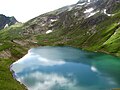 Engeratsgundsee001.JPG 2,032 × 1,524; 1.06 MB
 Engeratsgundsee002.JPG 1,524 × 2,032; 1.25 MB

