Category:E-road maps
Jump to navigation
Jump to search
Subcategories
This category has the following 10 subcategories, out of 10 total.
B
E
- Europe spanning E-road maps (103 F)
G
I
- Maps of european roads in Italy (31 F)
N
- Maps of european roads in Norway (27 F)
P
S
- SVG E-road maps (18 F)
U
Media in category "E-road maps"
The following 36 files are in this category, out of 36 total.
-
 E4 sketch Gavle-Tornia 2013.png 255 × 411; 20 KB
-
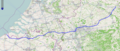
 European route E9.png 450 × 335; 51 KB
-
 Map E-road E20 overview.png 387 × 160; 15 KB
-
 E22 nordic.png 219 × 290; 25 KB
-
 E34 map.png 1,115 × 472; 952 KB
-
 E40 in Asia.png 428 × 308; 25 KB
-
 Map E70 overview.PNG 569 × 152; 14 KB
-
 Map-E79.PNG 196 × 274; 38 KB
-
 Map E90 overview.PNG 577 × 106; 33 KB
-
 E 233 Hoogeveen-Cloppenburg.png 1,096 × 378; 21 KB
-
 Europastrasse 233.png 1,096 × 378; 21 KB
-
 Traject E421.png 440 × 594; 56 KB
-
 E751-overview-map.svg 738 × 687; 110 KB
-
 E772.jpg 1,000 × 266; 127 KB
-
 E804.PNG 232 × 221; 8 KB
-
 Cropped European Highways UK-EI (3).jpg 505 × 686; 106 KB
-
 Czechia, European roads.png 1,259 × 744; 129 KB
-
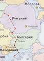
 DN14 főút Románia.png 796 × 600; 201 KB
-
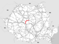
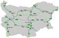 E-road BG.png 1,329 × 874; 192 KB
-
 E-roads in BY.png 400 × 338; 63 KB
-
 E-roads-Caucasus-countries.png 1,038 × 704; 139 KB
-
 E-roads-Turkey.png 634 × 324; 75 KB
-
 E001 map.png 2,043 × 1,177; 990 KB
-
 E002 map.png 2,052 × 1,193; 1,004 KB
-
 E117 map.png 2,010 × 1,176; 884 KB
-
 E4 sketch Gavle-Tornia 2016.png 255 × 411; 18 KB
-
 E4 sketch Gavle-Tornia 2021 (ver. 2016).png 255 × 411; 20 KB
-
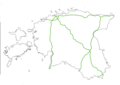 Eesti eteed.png 2,000 × 1,411; 151 KB
-
 EstonianERoads.png 800 × 523; 51 KB
-
 EstonianERoads2.png 800 × 523; 51 KB
-
 European Highways UK-EI tp.png 2,148 × 2,868; 53 KB
-
 European Highways UK-EI.png 1,587 × 2,696; 144 KB
-
 Finland european roads.png 455 × 800; 120 KB
-
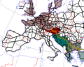 Gastarbeiterroute on E Road Network.png 500 × 400; 40 KB
-
 Geo Roads.jpg 1,494 × 807; 359 KB
-
 Map of Automobile Roads in Belarus M5 v2.png 400 × 338; 62 KB


.jpg)


.png)


