Category:Dunscore (civil parish)
Jump to navigation
Jump to search
Scottish parish in Dumfries and Galloway, Scotland, UK | |||||
| Upload media | |||||
| Instance of | |||||
|---|---|---|---|---|---|
| Named after | |||||
| Location |
| ||||
| Population |
| ||||
| Area |
| ||||
 | |||||
Media in category "Dunscore (civil parish)"
The following 200 files are in this category, out of 324 total.
(previous page) (next page)-
 A 76 near Burnside - geograph.org.uk - 2002405.jpg 640 × 463; 42 KB
-
 A 76 near turning for Irongray - geograph.org.uk - 2002389.jpg 640 × 477; 42 KB
-
 A boulder sign at Doddies Brae - geograph.org.uk - 1728310.jpg 640 × 427; 168 KB
-
 A clearance cairn - geograph.org.uk - 5938435.jpg 1,024 × 769; 372 KB
-
 A close encounter - geograph.org.uk - 3649522.jpg 640 × 424; 109 KB
-
 A drystane dyke on Skelston Hill - geograph.org.uk - 1714823.jpg 640 × 427; 137 KB
-
 A drystane dyke on Skelston Moor - geograph.org.uk - 1728408.jpg 640 × 427; 146 KB
-
 A forestry road in Craigenvey Forest - geograph.org.uk - 1729850.jpg 640 × 427; 133 KB
-
 A view of Laggan - geograph.org.uk - 3702270.jpg 640 × 424; 119 KB
-
 A view up Glencairn - geograph.org.uk - 5945370.jpg 1,024 × 769; 379 KB
-
 A76 at South Lodge - geograph.org.uk - 3476937.jpg 640 × 415; 55 KB
-
 A76 nearing Ellisland Farm - geograph.org.uk - 4587228.jpg 640 × 481; 47 KB
-
 A76 northbound - geograph.org.uk - 4257629.jpg 640 × 457; 37 KB
-
 A76 northbound - geograph.org.uk - 4257630.jpg 640 × 449; 36 KB
-
 A76 road junction - geograph.org.uk - 4257627.jpg 640 × 435; 34 KB
-
 A76 southbound at Penflowing Bridge - geograph.org.uk - 4587222.jpg 640 × 481; 64 KB
-
 A76 southbound near Moss Plantation - geograph.org.uk - 4587219.jpg 640 × 481; 50 KB
-
 Above McCubbington Farm - geograph.org.uk - 6489106.jpg 1,960 × 4,032; 2.18 MB
-
 An access track by Loch Urr - geograph.org.uk - 1719878.jpg 427 × 640; 157 KB
-
 Area of forest on Speddoch Moor - geograph.org.uk - 4574683.jpg 640 × 480; 100 KB
-
 B729 - geograph.org.uk - 4815115.jpg 1,024 × 768; 261 KB
-
 B729 at Throughgate village boundary - geograph.org.uk - 5902843.jpg 1,024 × 726; 124 KB
-
 B729 entering Dunscore village - geograph.org.uk - 5902845.jpg 1,024 × 743; 130 KB
-
 B729 near Birkshaw - geograph.org.uk - 5902846.jpg 1,024 × 807; 122 KB
-
 B729, Throughgate - geograph.org.uk - 4814917.jpg 1,024 × 768; 300 KB
-
 B729, Townhead - geograph.org.uk - 4815123.jpg 1,024 × 768; 298 KB
-
 Beech leaf carpet on fields near Allanton - geograph.org.uk - 5208125.jpg 1,024 × 655; 213 KB
-
 Below Crawston Hill - geograph.org.uk - 3702306.jpg 640 × 416; 150 KB
-
 Below Sundaywell Moor - geograph.org.uk - 5938390.jpg 1,024 × 769; 386 KB
-
 Beside the Castramon Burn - geograph.org.uk - 5938393.jpg 1,024 × 769; 401 KB
-
 Bessiewalla - geograph.org.uk - 4815057.jpg 1,024 × 768; 279 KB
-
 Bessiewalla Moor - geograph.org.uk - 4815041.jpg 1,024 × 768; 310 KB
-
 Bessiewalla Moor - geograph.org.uk - 4815091.jpg 1,024 × 768; 343 KB
-
 Black Brae - geograph.org.uk - 5933448.jpg 1,024 × 683; 315 KB
-
 Bridge, Glenesslin - geograph.org.uk - 5934153.jpg 1,024 × 683; 408 KB
-
 Brockloch Tower - geograph.org.uk - 3932672.jpg 2,637 × 3,556; 2.64 MB
-
 Burn, Lagg - geograph.org.uk - 5945395.jpg 1,024 × 769; 330 KB
-
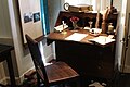
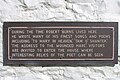
 Burns' Hermitage - geograph.org.uk - 3307107.jpg 1,024 × 768; 194 KB
-
 Cairn, Glenesslin - geograph.org.uk - 5938415.jpg 1,024 × 769; 365 KB
-
 Car Park at Ellisland Farm - geograph.org.uk - 5334631.jpg 2,592 × 1,728; 3.72 MB
-
 Car Park at Ellisland Farm - geograph.org.uk - 5334651.jpg 2,592 × 1,728; 4.02 MB
-
 Caravan Park near Ellisland - geograph.org.uk - 5208113.jpg 1,024 × 595; 143 KB
-
 Cart Store at Ellisland Farm - geograph.org.uk - 5334683.jpg 2,592 × 1,728; 2.59 MB
-
 Cart Store at Ellisland Farm - geograph.org.uk - 5334933.jpg 2,592 × 1,728; 2.27 MB
-
 Castramon Hill - geograph.org.uk - 3272740.jpg 2,560 × 1,920; 2.91 MB
-
 Castramon Hill - geograph.org.uk - 5938354.jpg 1,024 × 769; 287 KB
-
 Castramon Moor - geograph.org.uk - 1747128.jpg 640 × 427; 146 KB
-
 Cats Craig, Bogrie Hill - geograph.org.uk - 5857996.jpg 4,608 × 3,456; 5.03 MB
-
 Cattle near Corsefield - geograph.org.uk - 4815116.jpg 1,024 × 768; 309 KB
-
 Cattle near Dunscore - geograph.org.uk - 4815198.jpg 1,024 × 768; 338 KB
-
 Cattle near Townhead - geograph.org.uk - 4815121.jpg 1,024 × 768; 322 KB
-
 Cattle, Kenmore - geograph.org.uk - 5934157.jpg 1,024 × 647; 272 KB
-
 Church Crescent, Dunscore - geograph.org.uk - 4114960.jpg 1,920 × 1,280; 1.71 MB
-
 Climbing Black Brae - geograph.org.uk - 3697880.jpg 640 × 424; 148 KB
-
 Corsefield - geograph.org.uk - 4815134.jpg 1,024 × 768; 274 KB
-
 Courtyard at Ellisland Farm - geograph.org.uk - 5334677.jpg 2,592 × 1,728; 3.79 MB
-
 Craigenputtock - geograph.org.uk - 5938351.jpg 1,024 × 769; 386 KB
-
 Crawston - geograph.org.uk - 5933427.jpg 1,024 × 683; 326 KB
-
 Crawston Cottage - geograph.org.uk - 5933421.jpg 1,024 × 564; 173 KB
-
 Crawston Farm - geograph.org.uk - 3702260.jpg 640 × 352; 90 KB
-
 Crawston Hill - geograph.org.uk - 3739209.jpg 2,560 × 1,920; 2.79 MB
-
 Crawston Hill from Beacon Hill - geograph.org.uk - 2530793.jpg 2,592 × 1,944; 1.27 MB
-
 Crawston Hill from the air - geograph.org.uk - 6064654.jpg 1,024 × 768; 267 KB
-
 Crory Wood - geograph.org.uk - 5933432.jpg 1,024 × 683; 504 KB
-
 Cullie's Farmhouse, Ellisland - geograph.org.uk - 5334921.jpg 2,514 × 1,635; 566 KB
-
 Dempsterton - geograph.org.uk - 3702289.jpg 640 × 318; 86 KB
-
 Don't want to go there - geograph.org.uk - 5945691.jpg 1,024 × 769; 390 KB
-
 Drum - geograph.org.uk - 3702265.jpg 640 × 424; 152 KB
-
 Drumshangan - geograph.org.uk - 5857947.jpg 4,608 × 3,456; 5.25 MB
-
 Ducks by the Pond at Ellisland - geograph.org.uk - 5334886.jpg 2,592 × 1,728; 3.56 MB
-
 Dun Wood - geograph.org.uk - 5944905.jpg 1,024 × 769; 498 KB
-
 Dunscore - geograph.org.uk - 3697863.jpg 640 × 424; 74 KB
-
 Dunscore - geograph.org.uk - 4814938.jpg 1,024 × 768; 291 KB
-
 Dunscore Kirk - geograph.org.uk - 3504001.jpg 800 × 600; 121 KB
-
 Dunscore Kirk on an autumnal morning - geograph.org.uk - 3220820.jpg 1,200 × 803; 279 KB
-
 Dunscore Parish Church - geograph.org.uk - 4114933.jpg 1,920 × 1,280; 1.59 MB
-
 Dunscore Parish Church - geograph.org.uk - 4114938.jpg 1,280 × 1,920; 1.33 MB
-
 Dunscore Parish Church - geograph.org.uk - 4114941.jpg 1,920 × 1,280; 1.42 MB
-
 Dunscore Parish Church - geograph.org.uk - 4114943.jpg 1,280 × 1,920; 1.38 MB
-
 Dunscore Parish Church - geograph.org.uk - 4114957.jpg 1,920 × 1,280; 1.7 MB
-
 Dunscore Parish Church - geograph.org.uk - 4114962.jpg 1,920 × 1,280; 1.85 MB
-
 Dunscore Parish Church - geograph.org.uk - 5164935.jpg 1,067 × 1,600; 282 KB
-
 Dunscore Parish Church - geograph.org.uk - 5551493.jpg 4,000 × 3,000; 2.13 MB
-
 Dunscore Parish Church - geograph.org.uk - 5713083.jpg 640 × 480; 78 KB
-
 Dunscore Parish Church ^ Graveyard - geograph.org.uk - 4114948.jpg 1,920 × 1,280; 1.61 MB
-
 Dunscore Parish Church ^ Graveyard - geograph.org.uk - 4114951.jpg 1,280 × 1,920; 1.47 MB
-
 Dunscore Parish Church ^ Graveyard - geograph.org.uk - 4114955.jpg 1,920 × 1,280; 1.37 MB
-
 Dunscore to Glenmidge road - geograph.org.uk - 5945372.jpg 1,024 × 769; 373 KB
-
 Dunscore, Dumfriesshire - geograph.org.uk - 4814929.jpg 1,024 × 768; 330 KB
-
 Dyke, Drumshangan - geograph.org.uk - 5938423.jpg 1,024 × 769; 330 KB
-

-
 Ellisland Farm - geograph.org.uk - 4799594.jpg 2,000 × 1,500; 334 KB
-
 Ellisland Farm - geograph.org.uk - 5334634.jpg 2,592 × 1,728; 1.03 MB
-
 Ellisland Farm - geograph.org.uk - 5334658.jpg 2,592 × 1,728; 3.02 MB
-
 Ellisland Farm - geograph.org.uk - 5334669.jpg 2,592 × 1,728; 2.84 MB
-
 Ellisland Farm - geograph.org.uk - 5334674.jpg 2,592 × 1,728; 2.82 MB
-
 Ellisland Farm - geograph.org.uk - 5334889.jpg 2,592 × 1,728; 1.66 MB
-
 Ellisland Farm - geograph.org.uk - 5334892.jpg 1,728 × 2,592; 1.45 MB
-
 Ellisland Farm - geograph.org.uk - 5334896.jpg 1,728 × 2,592; 643 KB
-
 Ellisland Farm - geograph.org.uk - 5334900.jpg 2,592 × 1,728; 1.42 MB
-
 Ellisland Farm - geograph.org.uk - 5334906.jpg 1,728 × 2,592; 1.33 MB
-
 Ellisland Farm - geograph.org.uk - 5334907.jpg 2,592 × 1,728; 1.35 MB
-
 Ellisland Farm - geograph.org.uk - 5334914.jpg 2,592 × 1,728; 1.5 MB
-
 Ellisland Farm - geograph.org.uk - 5334916.jpg 2,592 × 1,728; 795 KB
-
 Ellisland Farm heritage centre ahead - geograph.org.uk - 3476955.jpg 640 × 333; 43 KB
-
 Ellisland Farm Sign - geograph.org.uk - 5334612.jpg 2,592 × 1,728; 4.03 MB
-
 Ellisland Farmhouse - geograph.org.uk - 5334713.jpg 2,592 × 1,728; 2.89 MB
-
 Enclosures at Doddiesliggat - geograph.org.uk - 5858012.jpg 4,608 × 3,456; 5.81 MB
-
 Entrance to Car Park at Ellisland Farm - geograph.org.uk - 5334645.jpg 2,592 × 1,728; 2.86 MB
-
 Entrance to Dunscore - geograph.org.uk - 4257636.jpg 640 × 472; 54 KB
-
 Entrance to Throughgate - geograph.org.uk - 4257633.jpg 640 × 480; 78 KB
-
 Exit from Ellisland Farm - geograph.org.uk - 5334596.jpg 2,592 × 1,728; 4.14 MB
-
 Exit Road from Ellisland Farm - geograph.org.uk - 5334641.jpg 2,592 × 1,728; 3.66 MB
-
 Farm buildings at Lagg - geograph.org.uk - 4100708.jpg 5,184 × 3,456; 7.55 MB
-
 Farm signs - geograph.org.uk - 3702277.jpg 640 × 424; 215 KB
-
 Farmland at Ellisland - geograph.org.uk - 5334938.jpg 2,592 × 1,728; 3.11 MB
-
 Farmland at Whiteside - geograph.org.uk - 1717728.jpg 640 × 407; 177 KB
-
 Farmland near Corse Bridge - geograph.org.uk - 5985438.jpg 2,592 × 1,944; 1.33 MB
-
 Felled and replanted woodland, Glenmidge - geograph.org.uk - 5945688.jpg 1,024 × 769; 359 KB
-
 Felled area, Durndrum Plantation - geograph.org.uk - 4815126.jpg 1,024 × 768; 282 KB
-
 Felling - geograph.org.uk - 5938373.jpg 1,024 × 769; 469 KB
-
 Field at Ellisland Farm - geograph.org.uk - 5334623.jpg 2,592 × 1,728; 3.03 MB
-
 Field at Ellisland Farm - geograph.org.uk - 5334935.jpg 2,592 × 1,728; 3.34 MB
-
 Field, Glenesslin - geograph.org.uk - 5938419.jpg 1,024 × 769; 347 KB
-
 Field, Lagganlees - geograph.org.uk - 4815336.jpg 1,024 × 768; 238 KB
-
 Fields above Blackstairs - geograph.org.uk - 5938433.jpg 1,024 × 769; 386 KB
-
 Fields by Lagganlees - geograph.org.uk - 4815339.jpg 1,024 × 768; 257 KB
-
 Fields near Brockhill Stone - geograph.org.uk - 2216559.jpg 640 × 428; 138 KB
-
 Fields near Dunscore - geograph.org.uk - 4814921.jpg 1,024 × 768; 307 KB
-
 Fields near Mansegate - geograph.org.uk - 4815196.jpg 1,024 × 768; 347 KB
-
 Fields ^ ponds west of Mansegate - geograph.org.uk - 2598786.jpg 3,872 × 2,592; 2.73 MB
-
 Flying Pig - geograph.org.uk - 4234172.jpg 640 × 480; 53 KB
-
 Forest edge - geograph.org.uk - 3112731.jpg 1,365 × 1,024; 1.08 MB
-
 Forest edge - geograph.org.uk - 3112834.jpg 1,365 × 1,024; 1.31 MB
-
 Forestry on the slope of Bogrie Hill - geograph.org.uk - 1391776.jpg 640 × 480; 64 KB
-
 Friars' Carse - geograph.org.uk - 3306040.jpg 1,600 × 1,200; 401 KB
-
 Gateside - geograph.org.uk - 5933409.jpg 1,024 × 683; 285 KB
-
 Glenesslin Burn - geograph.org.uk - 1326052.jpg 480 × 640; 149 KB
-
 Glenmidge - geograph.org.uk - 4100697.jpg 5,184 × 3,456; 7.47 MB
-
 Glenmidge - geograph.org.uk - 5945388.jpg 1,024 × 769; 327 KB
-
 Glenmidge - geograph.org.uk - 5945401.jpg 1,024 × 769; 388 KB
-
 Green box transport^ - geograph.org.uk - 2608384.jpg 3,264 × 2,448; 1.8 MB
-
 Greymare's Stone - geograph.org.uk - 1714827.jpg 640 × 427; 163 KB
-
 Greymare's Stone - geograph.org.uk - 1720086.jpg 640 × 427; 126 KB
-
 Hawthorn on Sundaywell Moor - geograph.org.uk - 3518366.jpg 640 × 384; 116 KB
-
 Hens ^ Bantams, Ellisland Farm - geograph.org.uk - 5334709.jpg 2,592 × 1,728; 3.38 MB
-
 Hummocky terrain, Blackstairs - geograph.org.uk - 5938429.jpg 1,024 × 769; 427 KB
-
 Jane Haining Memorial, Dunscore - geograph.org.uk - 2598754.jpg 2,592 × 3,872; 3.03 MB
-
 Junction for Burnhead - geograph.org.uk - 3476949.jpg 640 × 364; 80 KB
-
 Junction of roads in Milton - geograph.org.uk - 5551492.jpg 4,000 × 3,000; 2.62 MB
-
 Junction, Milton - geograph.org.uk - 3473056.jpg 640 × 480; 238 KB
-
 Kame and kettle terrain by Lagg - geograph.org.uk - 5945383.jpg 1,024 × 769; 364 KB
-
 Kenmure - geograph.org.uk - 3629345.jpg 1,024 × 678; 272 KB
-
 Killyleoch - geograph.org.uk - 4815023.jpg 1,024 × 768; 270 KB
-
 Killyleoch Hill - geograph.org.uk - 3112747.jpg 1,365 × 1,024; 1.32 MB
-
 Killyleoch Hill - geograph.org.uk - 3739008.jpg 2,560 × 1,920; 2.87 MB
-
 Kirkbride Hill - geograph.org.uk - 2530815.jpg 2,592 × 1,944; 1.41 MB
-
 Kirkgate, Dunscore - geograph.org.uk - 2598634.jpg 3,872 × 2,592; 3.64 MB
-
 Kirkgate, Dunscore - geograph.org.uk - 4114946.jpg 1,920 × 1,280; 1.46 MB
-
 Kirkgate, Dunscore - geograph.org.uk - 4114999.jpg 1,920 × 1,280; 1.39 MB
-
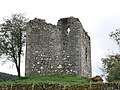
 Lag Tower - geograph.org.uk - 5945394.jpg 1,024 × 769; 472 KB
-
 Lag Tower armorial panel at Dunscore old cemetery, Dumfries & Galloway.jpg 4,608 × 3,456; 3.61 MB
-
 Lag Tower armorial panel, Dunscore old cemetery, Dumfries & Galloway.jpg 2,687 × 2,998; 4.79 MB
-

-

-

-

-
 Lag Tower from the farm, Dunscore, Dumfries & Galloway.jpg 4,608 × 3,456; 4.96 MB
-

-
-

-

-

-

-

-
 Lag Tower, external view of the north-east wall, Dunscore, Dumfries & Galloway.jpg 4,440 × 3,220; 5.3 MB
-
 Lag Tower, internal view of the north-west wall, Dunscore, Dumfries & Galloway.jpg 4,506 × 3,318; 6.53 MB
-
 Lag Tower, spiral stair remnants, Dunscore, Dumfries & Galloway.jpg 4,608 × 3,456; 3.61 MB
-
 Lagg Farm - geograph.org.uk - 2530804.jpg 2,592 × 1,944; 1.56 MB
-
 Lagg Farm - geograph.org.uk - 4100702.jpg 1,600 × 1,067; 546 KB
-
 Lagg Farm outbuilding - geograph.org.uk - 3702237.jpg 640 × 424; 128 KB
-
 Landscape near Dunscore - geograph.org.uk - 2598673.jpg 3,872 × 2,592; 2.44 MB
-
 Landscape near Dunscore - geograph.org.uk - 2598692.jpg 3,872 × 2,592; 2.27 MB
-
 Lane and cottage near Dunscore - geograph.org.uk - 2216547.jpg 640 × 428; 141 KB
-
 Linburn - geograph.org.uk - 4815132.jpg 1,024 × 768; 284 KB
-
 Local stone - geograph.org.uk - 3697869.jpg 640 × 424; 138 KB
-
 Loch Urr - geograph.org.uk - 1719863.jpg 640 × 398; 141 KB
-
 Loch Urr - geograph.org.uk - 1719897.jpg 640 × 427; 135 KB
-
 Lochurr Lane viewed from Craigenvey Bridge - geograph.org.uk - 4694686.jpg 1,600 × 1,067; 527 KB
-
 Lochview Place - geograph.org.uk - 4234082.jpg 640 × 480; 42 KB
-
 Lochview Place - geograph.org.uk - 4234097.jpg 640 × 480; 43 KB
-
 Log pile - geograph.org.uk - 5938377.jpg 1,024 × 769; 543 KB
-
 Lone pine on the Lagg road - geograph.org.uk - 3702235.jpg 640 × 415; 83 KB
-
 Looking across Dunscore Kirkyard - geograph.org.uk - 3697859.jpg 640 × 424; 121 KB
-
 Looking East - geograph.org.uk - 3702253.jpg 640 × 353; 69 KB
-
 Lower Linburn - geograph.org.uk - 2598792.jpg 3,872 × 2,592; 3.68 MB
-
 Meiklewood Moss - geograph.org.uk - 6489879.jpg 1,600 × 778; 479 KB
-
 Memorial Bench, Ellisland - geograph.org.uk - 5334757.jpg 2,592 × 1,728; 4.49 MB
-
 Midsteeple Milepost - geograph.org.uk - 5334865.jpg 2,592 × 1,728; 4.17 MB
-
 Milk Urns at Ellisland Farm - geograph.org.uk - 5334931.jpg 2,592 × 1,728; 2.65 MB


&filefrom=Milton+and+Dunscore+from+the+air+-+geograph.org.uk+-+5411303.jpg#mw-category-media)