Category:Duchesne River
Jump to navigation
Jump to search
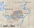
river in the Uinta Basin in Duchesne and Uintah counties in Utah, United States  | |||||
| Upload media | |||||
| Instance of | |||||
|---|---|---|---|---|---|
| Location |
| ||||
| Length |
| ||||
| Elevation above sea level |
| ||||
| Mouth of the watercourse | |||||
| Drainage basin |
| ||||
 | |||||
Subcategories
This category has the following 11 subcategories, out of 11 total.
B
- Bridgeland, Utah (1 F)
D
H
- Hanna, Utah (1 F)
M
O
- Ouray, Utah (2 F)
R
S
- Stockmore Ranger Station (2 F)
T
- Tabiona, Utah (4 F)
U
Media in category "Duchesne River"
The following 11 files are in this category, out of 11 total.
-

-

-

-
 Duchesne County, UT, USA - panoramio.jpg 2,292 × 3,056; 1.17 MB
-
 Duchesne river basin map.png 1,206 × 1,046; 2.08 MB
-
 Duchesnerivermap.png 720 × 586; 300 KB
-
 Green River at Ouray Utah.jpg 2,688 × 1,512; 936 KB
-
 North Fork Duchesne Canyon - Social 1.jpg 2,048 × 1,536; 692 KB
-
 North Fork Duchesne Canyon - Social 2.jpg 850 × 580; 164 KB
-

-


Categories:
- Rivers of Utah
- Bodies of water in Duchesne County, Utah
- Bodies of water in Uintah County, Utah
- Green River (Colorado River) in Utah
- Rivers of the United States by name
- Tributaries of the Colorado River in Utah
- Bodies of water in the Uinta Basin
- Uinta Mountains
- High Uintas Wilderness
- Ashley National Forest
- Wasatch-Cache National Forest
- Bodies of water on the Uintah and Ouray Indian Reservation
- Locations along U.S. Route 40 in Duchesne County, Utah
- Locations along U.S. Route 191 in Duchesne County, Utah
- Locations along Utah State Route 6 (1910-1977) in Duchesne County, Utah
- Locations along Utah State Route 35 in Duchesne County, Utah
- Locations along Utah State Route 86 (1935-1969)
- Locations along Utah State Route 208
- Locations along the Dinosaur Diamond Prehistoric Highway in Duchesne County, Utah