Category:Dorfkirche Damsdorf
Jump to navigation
Jump to search
| Object location | | View all coordinates using: OpenStreetMap |
|---|
church building in Brandenburg state, Germany  | |||||
| Upload media | |||||
| Instance of | |||||
|---|---|---|---|---|---|
| Location | Damsdorf (Kloster Lehnin), Kloster Lehnin, Potsdam-Mittelmark District, Brandenburg, Germany | ||||
| Heritage designation | |||||
 | |||||
This is the category of the Brandenburger Baudenkmal (cultural heritage monument) with the ID 09190132 (Wikidata)
|
Deutsch: Ansichten der Kirche in Damsdorf, Gemeinde Kloster Lehnin, Landkreis Potsdam-Mittelmark, Land Brandenburg, Deutschland.
English: Pictures of the church in Damsdorf, Kloster Lehnin municipality, Potsdam-Mittelmark district, Brandenburg state, Germany.
Français : Photos de l'église à Damsdorf, commune de Kloster Lehnin, arrondissement de Potsdam-Mittelmark, état fédéral de Brandebourg, Allemagne
Español: Vistas de la iglesia en Damsdorf, municipio de Kloster Lehnin, distrito de Potsdam-Mittelmark, estado federado de Brandeburgo, Alemania
Pages in category "Dorfkirche Damsdorf"
This category contains only the following page.
Media in category "Dorfkirche Damsdorf"
The following 12 files are in this category, out of 12 total.
-
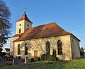
 Dorfkirche Damsdorf 2020 NW.jpg 4,864 × 3,648; 5.42 MB
-
 Dorfkirche Damsdorf 2020 SE.jpg 4,591 × 3,746; 6.76 MB
-
 Damsdorf church.jpg 1,320 × 1,830; 325 KB
-
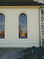 Dorfkirche Damsdorf 2020 Fenster.jpg 3,636 × 4,854; 5.03 MB
-
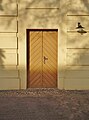 Dorfkirche Damsdorf 2020 Südportal.jpg 3,538 × 4,782; 4.7 MB
-
 Dorfkirche Damsdorf 2020 Turmhaube.jpg 3,538 × 4,782; 4.3 MB
-
 Dorfkirche Damsdorf 2020 Westportal.jpg 3,636 × 4,854; 7.22 MB
-
 Dorfkirche Damsdorf 2020 WNW.jpg 3,648 × 4,864; 6.37 MB
-
 Dorfkirche Damsdorf 2020 WSW.jpg 4,864 × 3,648; 6.92 MB
-
 Kirche Damsdorf Turm.jpg 1,932 × 2,576; 1.57 MB
-
 Kirche Damsdorf, Seitenansicht.jpg 2,576 × 1,932; 1.65 MB
-
 Kirche, Damsdorf.jpg 2,576 × 1,932; 1.74 MB


