Category:Damsdorf (Kloster Lehnin)
Jump to navigation
Jump to search
| Object location | | View all coordinates using: OpenStreetMap |
|---|
village in Brandenburg state, Germany  | |||||
| Upload media | |||||
| Instance of |
| ||||
|---|---|---|---|---|---|
| Location | Kloster Lehnin, Potsdam-Mittelmark District, Brandenburg, Germany | ||||
| Elevation above sea level |
| ||||
 | |||||
Deutsch: Das Dorf Damsdorf gehört zur Gemeinde Kloster Lehnin , Landkreis Potsdam-Mittelmark , Land Brandenburg, Deutschland.
English: The village Damsdorf belongs to Kloster Lehnin municipality , Potsdam-Mittelmark district, Brandenburg state, Germany
Français : Le village de Damsdorf fait partie de la commune de Kloster Lehnin , arrondissement de Potsdam-Mittelmark , état fédéral de Brandebourg, Allemagne
Español: El pueblo de Damsdorf es parte del municipio de Kloster Lehnin , distrito de Potsdam-Mittelmark , estado federado de Brandeburgo, Alemania
Subcategories
This category has the following 2 subcategories, out of 2 total.
D
- Dorfkirche Damsdorf (1 P, 12 F)
L
Media in category "Damsdorf (Kloster Lehnin)"
The following 8 files are in this category, out of 8 total.
-
 AlteSchmiedeDamsdorf.jpg 2,576 × 1,932; 1.76 MB
-
 AmtsvorwerkDamsdorf.jpg 2,576 × 1,932; 1.8 MB
-

-
-
 ChausseehausDamsdorf.jpg 1,596 × 1,284; 927 KB
-
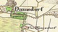 Dahmsdorf-Urmesstischblatt 3642 Lehnin 1839.jpg 728 × 398; 44 KB
-
 Grundschule Damsdorf (Kloster Lehnin) 2025 S.jpg 4,032 × 3,024; 4.48 MB
-
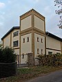 Kloster Lehnin Damsdorf Wasserturm.jpg 2,632 × 3,509; 1.82 MB


_2025_S.jpg)
