Category:December 2005 in the East Riding of Yorkshire
Jump to navigation
Jump to search
Ceremonial counties of England: Bedfordshire · Berkshire · Buckinghamshire · Cambridgeshire · Cheshire · Cornwall · Cumbria · Derbyshire · Devon · Dorset · Durham · East Riding of Yorkshire · East Sussex · Essex · Gloucestershire · Greater London · Greater Manchester · Hampshire · Herefordshire · Hertfordshire · Isle of Wight · Kent · Lancashire · Leicestershire · Lincolnshire · Merseyside · Norfolk · North Yorkshire · Northamptonshire · Northumberland · Nottinghamshire · Oxfordshire · Rutland · Shropshire · Somerset · South Yorkshire · Staffordshire · Suffolk · Surrey · Tyne and Wear · Warwickshire · West Midlands · West Sussex · West Yorkshire · Wiltshire · Worcestershire
City-counties: Bristol ·
Former historic counties:
Other former counties:
City-counties: Bristol ·
Former historic counties:
Other former counties:
Deutsch: Bilder, die im Dezember 2005 in the East Riding of Yorkshire aufgenommen worden sind. Bitte beachten Sie, dass dies weder das Datum des Uploads noch das Datum des Scannens eines Fotos ist.
English: Images/pictures taken in the East Riding of Yorkshire during December 2005. Note this is not the date of the upload, nor the date a photo was scanned.
Español: Fotografías o imágenes tomadas en the East Riding of Yorkshire durante diciembre 2005. No es la fecha de subida ni escaneo, sino la fecha en que las fotografías o imágenes se crearon.
Esperanto: Bildoj faritaj en the East Riding of Yorkshire en decembro 2005. Tio ne estas la dato, kiam la bildoj estis alŝutitaj aŭ skanitaj.
Français : Photographies ou images prises en the East Riding of Yorkshire durant décembre 2005. Ce n'est pas la date du téléchargement ou du scan.
Galego: Fotografías ou imaxes tomadas en the East Riding of Yorkshire durante decembro 2005. Non é a data de subida nin escaneamento, senón a data na que se crearon as fotografías ou imaxes.
Italiano: Fotografie o immagini scattate a the East Riding of Yorkshire nel dicembre 2005. Nota bene: la data non si riferisce né a quella di upload né a quella in cui la foto è stata digitalizzata.
Norsk bokmål: Bilder tatt i the East Riding of Yorkshire i løpet av desember 2005. Merk at dette ikke er datoen for opplasting, eller når et bilde har blitt skannet.
Norsk nynorsk: Bilete teke i the East Riding of Yorkshire i løpet av desember 2005. Merk at dette ikkje er datoen for opplasting, eller når eit bilete har vorte skanna.
Русский: Изображения, сделанные в the East Riding of Yorkshire в течение декабрь 2005 (не дата загрузки изображения).
Українська: Зображення, зроблені в the East Riding of Yorkshire протягом грудень 2005. Зауважте, що це не дата завантаження чи дата сканування фотографії.
| December 2004 | ← | December 2005 | → | December 2006 | |||||||
| Jan | Feb | Mar | Apr | May | Jun | Jul | Aug | Sep | Oct | Nov | Dec |
| 23 | 27 | 22 | 43 | 206 | 113 | 137 | 242 | 129 | 235 | 161 | 120 |
|---|---|---|---|---|---|---|---|---|---|---|---|
Media in category "December 2005 in the East Riding of Yorkshire"
The following 120 files are in this category, out of 120 total.
-
 'Morrisons' Roundabout, Beverley - geograph.org.uk - 97635.jpg 640 × 480; 66 KB
-
 A164 - A1079 - geograph.org.uk - 97636.jpg 640 × 480; 135 KB
-
 A164 near West Ella - geograph.org.uk - 87905.jpg 640 × 480; 122 KB
-
 Barmston church - geograph.org.uk - 100548.jpg 640 × 427; 99 KB
-
 Barmston Sands - geograph.org.uk - 100551.jpg 640 × 427; 100 KB
-
 Barmston Wesleyan Chapel - geograph.org.uk - 100552.jpg 640 × 427; 82 KB
-
 Bay Horse Public House East Cowick.jpg 640 × 427; 104 KB
-
 Beeford - geograph.org.uk - 100563.jpg 640 × 427; 87 KB
-
 Bentley - geograph.org.uk - 97612.jpg 640 × 480; 165 KB
-
 Bishop Burton - SE - geograph.org.uk - 97620.jpg 640 × 480; 153 KB
-
 Bishop Burton - SW - geograph.org.uk - 97622.jpg 640 × 480; 104 KB
-
 Bishop Burton Wold - geograph.org.uk - 99927.jpg 640 × 480; 160 KB
-
 Bishop Burton Wold - geograph.org.uk - 99930.jpg 640 × 480; 106 KB
-
 Bishop Burton Wold - North - geograph.org.uk - 99932.jpg 640 × 480; 106 KB
-
 Black Mill on the Westwood, Beverley. - geograph.org.uk - 259143.jpg 640 × 480; 41 KB
-
 Boxing Day Hunt - geograph.org.uk - 97631.jpg 640 × 480; 101 KB
-
 Bramble Hill, Beverley - geograph.org.uk - 97936.jpg 640 × 480; 110 KB
-
 Brantingham Village Duck Pond.jpg 640 × 427; 184 KB
-
 Bridge over the A1079 - geograph.org.uk - 97945.jpg 640 × 480; 100 KB
-
 British Isles rural and coastal Making Britain Great (81003111).jpg 800 × 532; 119 KB
-
-
 Burn Butts - geograph.org.uk - 90068.jpg 640 × 480; 112 KB
-
 Burton Rakes - geograph.org.uk - 99928.jpg 640 × 480; 158 KB
-
 Bushy Hill Farm - geograph.org.uk - 97922.jpg 640 × 480; 132 KB
-
 Castle Road - geograph.org.uk - 87520.jpg 640 × 480; 125 KB
-
 Cherry Burton - Road to Etton - geograph.org.uk - 97958.jpg 640 × 480; 116 KB
-
 Cherry Burton.jpg 640 × 480; 91 KB
-
 Coast near Ulrome - geograph.org.uk - 100569.jpg 640 × 427; 62 KB
-
 Cold Harbour - geograph.org.uk - 99924.jpg 640 × 480; 119 KB
-
 College of Agriculture - geograph.org.uk - 99936.jpg 640 × 480; 120 KB
-
 Cowick Hall.jpg 640 × 427; 100 KB
-
 Davenport Avenue, Hessle - geograph.org.uk - 94771.jpg 640 × 460; 71 KB
-
 Deep Dale - geograph.org.uk - 97930.jpg 640 × 480; 179 KB
-
 Dunkenhill Farm - geograph.org.uk - 99940.jpg 640 × 480; 138 KB
-
 Endike Lane - East - geograph.org.uk - 87512.jpg 640 × 480; 81 KB
-
 Ennerdale - geograph.org.uk - 87508.jpg 640 × 480; 92 KB
-
 Etton - geograph.org.uk - 97954.jpg 640 × 480; 137 KB
-
 Etton West Wood - geograph.org.uk - 97953.jpg 640 × 480; 91 KB
-
 Farmland - Willerby Low Road - geograph.org.uk - 87519.jpg 640 × 480; 80 KB
-
 Farmland at North Frodingham Carrs - geograph.org.uk - 100585.jpg 640 × 427; 100 KB
-
 Farmland at SE962375 View North - geograph.org.uk - 97916.jpg 640 × 480; 215 KB
-
 Farmland at SE962375 View North - geograph.org.uk - 97918.jpg 640 × 480; 135 KB
-
 Farmland at SE9859851526 - geograph.org.uk - 90230.jpg 640 × 480; 163 KB
-
 Farmland at TA0013954011 - geograph.org.uk - 90118.jpg 640 × 480; 253 KB
-
 Farmland North of Bentley - geograph.org.uk - 97614.jpg 640 × 480; 118 KB
-
 Farmland North of Bracken - geograph.org.uk - 90226.jpg 640 × 480; 168 KB
-
 Farmland north of Tickton - geograph.org.uk - 100578.jpg 640 × 427; 76 KB
-
 Footpath at SE985523 - geograph.org.uk - 90072.jpg 480 × 640; 245 KB
-
 Front Street, Lockington - geograph.org.uk - 90063.jpg 640 × 480; 152 KB
-
 Grange Farm - geograph.org.uk - 99939.jpg 640 × 480; 132 KB
-
 Haggs Farm - geograph.org.uk - 87517.jpg 640 × 480; 143 KB
-
 Heading to Kirkburn - geograph.org.uk - 90071.jpg 640 × 480; 220 KB
-
 High Hunsley trig - geograph.org.uk - 100575.jpg 640 × 427; 136 KB
-
 Holwell Road, Bransholme - geograph.org.uk - 87507.jpg 640 × 480; 95 KB
-
 Hook Nr Goole, Blacksmiths Arms.jpg 640 × 480; 146 KB
-
 Houses on the B1230 - geograph.org.uk - 97944.jpg 640 × 480; 143 KB
-
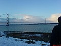
 Humber - Hessle 811.jpg 1,600 × 1,200; 824 KB
-
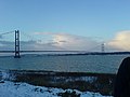 Humber Bridge in the snow - geograph.org.uk - 109084 (cropped).jpg 600 × 450; 57 KB
-
 Humber Bridge in the snow - geograph.org.uk - 109084.jpg 640 × 480; 64 KB
-
 Lane into North Frodingham - geograph.org.uk - 100584.jpg 640 × 427; 80 KB
-
 Lay-by on the A1079 - geograph.org.uk - 99938.jpg 640 × 480; 115 KB
-
 Lissett church - geograph.org.uk - 100555.jpg 640 × 427; 151 KB
-
 Little Wood - geograph.org.uk - 97919.jpg 640 × 480; 191 KB
-
 Littlewood Farm - geograph.org.uk - 97931.jpg 640 × 480; 153 KB
-
 Long Riston church - geograph.org.uk - 100581.jpg 640 × 427; 69 KB
-
 Looking N from site of Billings Hill trig - geograph.org.uk - 100582.jpg 640 × 427; 111 KB
-
 NE of Bishop Burton - geograph.org.uk - 99934.jpg 640 × 480; 119 KB
-
 NE of Little Weighton - geograph.org.uk - 97606.jpg 640 × 480; 120 KB
-
 Near Ella Hill - geograph.org.uk - 97934.jpg 640 × 480; 161 KB
-
 Near Westfield Farm - geograph.org.uk - 97629.jpg 640 × 480; 185 KB
-
 Newbald Wold - geograph.org.uk - 97924.jpg 640 × 480; 128 KB
-
 Newbald, Bishop Burton Road - geograph.org.uk - 97633.jpg 640 × 480; 105 KB
-
 North Cave Church - geograph.org.uk - 93041.jpg 640 × 427; 153 KB
-
 North Newbald - geograph.org.uk - 93016.jpg 640 × 427; 109 KB
-
 North Newbald - geograph.org.uk - 97927.jpg 640 × 480; 168 KB
-
 North Newbald - Paddock - geograph.org.uk - 97926.jpg 640 × 480; 149 KB
-
 North OF Bracken - geograph.org.uk - 90067.jpg 640 × 480; 180 KB
-
 Northlands - geograph.org.uk - 97617.jpg 640 × 480; 92 KB
-
 NW of Etton - geograph.org.uk - 97951.jpg 640 × 480; 99 KB
-
 Park Farm - geograph.org.uk - 97626.jpg 640 × 480; 154 KB
-

-
 Rawcliffe Near Goole, Rawcliffe Church - geograph.org.uk - 89343.jpg 640 × 427; 93 KB
-
 Risby.jpg 640 × 480; 177 KB
-
 River Hull north of Beverley - geograph.org.uk - 100576.jpg 640 × 427; 98 KB
-
 Road to Bishop Burton - geograph.org.uk - 99921.jpg 640 × 480; 133 KB
-
 Road to Cherry Burton - geograph.org.uk - 99919.jpg 640 × 480; 120 KB
-
 Road to Southburn - geograph.org.uk - 90123.jpg 640 × 480; 197 KB
-
 Routh church.jpg 640 × 427; 118 KB
-
 Skeffling Soak Dike - geograph.org.uk - 313849.jpg 640 × 480; 94 KB
-
 Skidby scarecrow (81758278).jpg 3,008 × 2,000; 3.97 MB
-
 South Newbald - geograph.org.uk - 97928.jpg 480 × 640; 156 KB
-
 South of Bishop Burton - geograph.org.uk - 99920.jpg 640 × 480; 128 KB
-
 Southbelt Plantation - geograph.org.uk - 90065.jpg 640 × 480; 131 KB
-
 Southburn - geograph.org.uk - 90115.jpg 640 × 480; 145 KB
-

-
 St Andrew's Church, Kirk Ella.jpg 640 × 480; 128 KB
-
 St Marys Church Lockington.jpg 640 × 480; 134 KB
-
 St. Mary's , Kirkburn - geograph.org.uk - 90154.jpg 640 × 480; 94 KB
-
 Sunrise at Tunstall - geograph.org.uk - 108116.jpg 640 × 480; 19 KB
-
 Sunrise to East of Back Lane Fangfoss - geograph.org.uk - 734652.jpg 640 × 426; 67 KB
-
 SW of Southburn - geograph.org.uk - 90083.jpg 640 × 480; 126 KB
-
 TI Rallyschool, Melbourne Airfield - geograph.org.uk - 486303.jpg 640 × 480; 69 KB
-
 Tibthorpe.jpg 640 × 480; 134 KB
-

-
 Ulrome church.jpg 640 × 427; 85 KB
-
 Ulrome Sands - geograph.org.uk - 100566.jpg 640 × 427; 71 KB
-
 View along the B1230 - geograph.org.uk - 97947.jpg 640 × 480; 118 KB
-
 View E from Low Caythorpe trig - geograph.org.uk - 100546.jpg 640 × 427; 143 KB
-
 View from the A164 - geograph.org.uk - 87521.jpg 640 × 480; 128 KB
-
 Water Treatment Works - geograph.org.uk - 97952.jpg 640 × 480; 130 KB
-
 West Ella.jpg 640 × 480; 140 KB
-
 West of Etton - geograph.org.uk - 97949.jpg 640 × 480; 92 KB
-
 West of Kilnwick - geograph.org.uk - 90066.jpg 640 × 480; 94 KB
-
 Westwood Pasture - geograph.org.uk - 97940.jpg 640 × 480; 91 KB
-
 White Hall - geograph.org.uk - 97939.jpg 640 × 480; 91 KB
-

-
 Whitgift Lighthouse.jpg 640 × 427; 101 KB
-
 Willerby Low Road - geograph.org.uk - 87515.jpg 640 × 480; 118 KB
-
 Endike Lane - Looking West - geograph.org.uk - 87513.jpg 640 × 480; 128 KB
-
 Kesteven Way - geograph.org.uk - 87510.jpg 640 × 480; 91 KB


.jpg)


.jpg)


.jpg)


_-_geograph.org.uk_-_94689.jpg)


