
Category:Crow Point Light
| Object location | | View all coordinates using: OpenStreetMap |
|---|
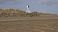
English: Crow Point Lighthouse
lighthouse in North Devon, England  | |||||
| Upload media | |||||
| Instance of | |||||
|---|---|---|---|---|---|
| Location | Braunton Burrows, Braunton, North Devon, Devon, South West England, England | ||||
| Operator | |||||
| Inception |
| ||||
| Source of energy | |||||
| Height |
| ||||
 | |||||
Media in category "Crow Point Light"
The following 2 files are in this category, out of 2 total.
-
 Crow Point - geograph.org.uk - 717034.jpg 640 × 359; 249 KB
-
 Crow point beacon - geograph.org.uk - 126137.jpg 640 × 480; 54 KB