Category:Continental Divide Trail in Colorado
Jump to navigation
Jump to search
Subcategories
This category has the following 2 subcategories, out of 2 total.
C
S
- Searle Pass (2 F)
Media in category "Continental Divide Trail in Colorado"
The following 21 files are in this category, out of 21 total.
-
 CDT sign, Berthoud Pass.jpg 2,848 × 2,136; 2.05 MB
-
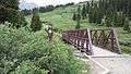 CDT sign, footbridge at Grays Peak Trailhead.jpg 3,264 × 1,836; 2.08 MB
-
 CDT to Fall River.jpg 2,136 × 2,848; 1.84 MB
-
 CO Mines 6.jpg 2,848 × 2,136; 2.17 MB
-
 Colorado Tr, Continental Divide Tr, N Mt Elbert Tr Jct. sign, Mt Elbert Trailhead.jpg 3,264 × 1,836; 797 KB
-
 Continental Divide Trail at Camp Hale.JPG 5,801 × 3,594; 18.11 MB
-
 Continental Divide Trail at Marshall Pass.JPG 4,030 × 3,646; 12.14 MB
-
 Continental divide trail in Weminuche Wilderness.jpg 2,048 × 1,536; 1.28 MB
-
 Continental Divide Trail trailhead at Tennessee Pass.JPG 6,000 × 3,662; 18.83 MB
-
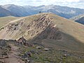
 Continental Divide Trail up Torreys Peak.jpg 1,836 × 3,264; 2.18 MB
-
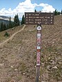
 Continental Divide Trail, Berthoud Pass sign 1.jpg 2,848 × 2,136; 2.19 MB
-
 Continental Divide Trail, Berthoud Pass sign 2.jpg 2,848 × 2,136; 2.12 MB
-
 Continental Divide Trail, Berthoud Pass sign 3.jpg 2,848 × 2,136; 2.08 MB
-
 Continental Divide Trail, Berthoud Pass sign 4.jpg 2,848 × 2,136; 1.99 MB
-
 Continental Divide Trail, Torreys to Grays.jpg 3,264 × 1,836; 1.49 MB
-
 Footbridge, Colorado Trail near N Elbert Trailhead.jpg 3,264 × 1,836; 945 KB
-
 Mt Elbert Trailhead info signs.jpg 3,264 × 1,836; 870 KB
-
 Mt Elbert, Colorado Trail, Halfmoon Road, CD signs.jpg 3,264 × 1,836; 2.21 MB
-
 Mt. Elbert sign, The Colorado Trail.jpg 3,264 × 1,836; 1.59 MB
-
 The Colorado Trail, The Continental Divide Trail, N Elbert Creek TH signs.jpg 3,264 × 1,836; 2.34 MB
-
 USGS North Park Basin geologic map.png 779 × 600; 209 KB


