Category:Colorado State Highway 12
Jump to navigation
Jump to search
 | number: | (twelve) |
|---|---|---|
| State highways in Colorado: | 1 · 2 · 3 · 5 · 7 · 8 · 9 · 10 · 11 · 12 · 13 · 14 · 15 · 16 · 17 · 21 · 22 · 23 · 26 · 30 |
state highway in Huerfano and Las Animas counites in Colorado, United States   | |||||
| Upload media | |||||
| Instance of | |||||
|---|---|---|---|---|---|
| Location |
| ||||
| Transport network | |||||
| Owned by | |||||
| Maintained by | |||||
| Length |
| ||||
| Terminus |
| ||||
| |||||
Subcategories
This category has the following 3 subcategories, out of 3 total.
Media in category "Colorado State Highway 12"
The following 12 files are in this category, out of 12 total.
-
 Colorado 12.svg 601 × 601; 5 KB
-
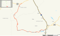 Colorado State Highway 12 Map.svg 1,028 × 609; 532 KB
-
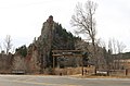
 Cuchara Formation.JPG 3,342 × 2,484; 7.91 MB
-
 Cuchara, Colorado.JPG 4,493 × 3,456; 10.77 MB
-
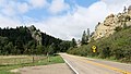
 Dakota Wall at Stonewall Gap.JPG 4,739 × 3,139; 11.04 MB
-
 Jansen, Colorado.JPG 5,353 × 3,933; 15.1 MB
-
 Sangre de Cristo Formation.JPG 6,000 × 4,000; 23.1 MB
-
 Segundo, Colorado.JPG 5,184 × 2,402; 7.15 MB
-
 Stonewall Gap, Colorado.JPG 5,370 × 3,331; 9.65 MB
-
 The Gap near Cuchara, Colorado.JPG 5,822 × 3,297; 13.69 MB
-
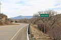 Valdez, Colorado.JPG 6,000 × 4,000; 8.49 MB
-
 Weston Supply in Weston, Colorado.JPG 4,117 × 2,476; 6.62 MB


