Category:Carnwath (civil parish)
Jump to navigation
Jump to search
Scottish parish in South Lanarkshire, Scotland, UK | |||||
| Upload media | |||||
| Instance of | |||||
|---|---|---|---|---|---|
| Part of |
| ||||
| Named after | |||||
| Location |
| ||||
| Population |
| ||||
| Area |
| ||||
 | |||||
Subcategories
This category has the following 5 subcategories, out of 5 total.
A
C
F
N
T
Media in category "Carnwath (civil parish)"
The following 200 files are in this category, out of 729 total.
(previous page) (next page)-
 18thC tombstone, Carnwath - geograph.org.uk - 2102991.jpg 480 × 640; 109 KB
-
 78-83 Crosswood Terrace, Tarbrax - geograph.org.uk - 2811008.jpg 3,264 × 2,448; 2.54 MB
-
 A Bench-Marked Bridge - geograph.org.uk - 2972878.jpg 640 × 441; 82 KB
-
 A cutting through a kame at Newbigging - geograph.org.uk - 6133364.jpg 3,264 × 2,448; 4.67 MB
-
 A former filling station at Carnwath - geograph.org.uk - 1863439.jpg 639 × 378; 148 KB
-
 A grass field near Spittal - geograph.org.uk - 2474066.jpg 640 × 480; 294 KB
-
 A late cut of grass for silage - geograph.org.uk - 5581033.jpg 3,264 × 2,448; 4.4 MB
-
 A late silage crop near Carnwath - geograph.org.uk - 5581550.jpg 3,264 × 2,448; 4.77 MB
-
 A letter to Robert Wilson - geograph.org.uk - 5541180.jpg 3,264 × 2,448; 1.96 MB
-
 A meander of the South Medwin - geograph.org.uk - 6133403.jpg 3,264 × 2,448; 4.7 MB
-
 A motte at Carnwarth Golf Course - geograph.org.uk - 1876221.jpg 640 × 427; 143 KB
-
 A short logging road, Carnwath Moss - geograph.org.uk - 2914954.jpg 640 × 480; 297 KB
-
 A sorry tale^ - geograph.org.uk - 5541092.jpg 2,448 × 3,264; 4.24 MB
-
 A70 - A721 Road Junction in Carnwath - geograph.org.uk - 3663547.jpg 640 × 480; 81 KB
-
 A706 - geograph.org.uk - 2043161.jpg 640 × 359; 111 KB
-
 Access road, Black Law wind farm - geograph.org.uk - 4314770.jpg 800 × 533; 155 KB
-
 Ampherlaw House - geograph.org.uk - 5993288.jpg 3,264 × 2,448; 5.41 MB
-
 Ampherlaw Wood - geograph.org.uk - 2112649.jpg 640 × 480; 138 KB
-
 Ampherlaw Wood - geograph.org.uk - 2112666.jpg 640 × 480; 116 KB
-
 An entrance to Ross Wood - geograph.org.uk - 5992586.jpg 3,264 × 2,448; 5.58 MB
-
 An entrance to Ross Wood - geograph.org.uk - 5993560.jpg 3,264 × 2,448; 6.1 MB
-
 An old sign on a fence - geograph.org.uk - 1870426.jpg 640 × 427; 155 KB
-
 An unfenced area, Cleuch Mill - geograph.org.uk - 1900526.jpg 640 × 359; 71 KB
-
 Approaching Carnwath - geograph.org.uk - 5109508.jpg 2,592 × 1,936; 1.44 MB
-
 Approaching Carnwath from the west - geograph.org.uk - 6175902.jpg 1,600 × 1,060; 486 KB
-
 Aqueduct, Burngrange - geograph.org.uk - 2270561.jpg 640 × 359; 217 KB
-
 Ash trees by the Mosshat Burn - geograph.org.uk - 5538743.jpg 3,264 × 2,448; 4.82 MB
-
 Auchengray to Wilsontown road - geograph.org.uk - 2043296.jpg 640 × 359; 103 KB
-
 B7016 - geograph.org.uk - 3728090.jpg 640 × 480; 258 KB
-
 B7016, Cleuch Mill - geograph.org.uk - 1900528.jpg 640 × 359; 72 KB
-
 Backmoor Wood - clear felled - geograph.org.uk - 5992098.jpg 3,264 × 2,448; 3.13 MB
-
 Backmoor Wood - geograph.org.uk - 2325331.jpg 640 × 480; 289 KB
-
 Backmoor Wood - geograph.org.uk - 2325339.jpg 640 × 480; 294 KB
-
 Backmoor Wood - geograph.org.uk - 5992099.jpg 3,264 × 2,448; 3.86 MB
-
 Bakery and garage, Biggar Road, Carnwath - geograph.org.uk - 3385475.jpg 2,592 × 1,936; 1.84 MB
-
 Base on a base - geograph.org.uk - 2060192.jpg 640 × 480; 73 KB
-
 Beech lined road - geograph.org.uk - 1894400.jpg 640 × 480; 177 KB
-
 Beech lined road, Scabgill - geograph.org.uk - 1894766.jpg 640 × 480; 182 KB
-
 Beeches, near Braehead - geograph.org.uk - 1900503.jpg 640 × 480; 110 KB
-
 Bell pit at Wilsontown - geograph.org.uk - 5541108.jpg 3,264 × 2,448; 5.56 MB
-
 Benry Bog, near Cobbinshaw - geograph.org.uk - 5580939.jpg 3,264 × 2,448; 1.83 MB
-
 Benthead Farm - geograph.org.uk - 2517941.jpg 4,000 × 3,000; 3.24 MB
-
 Benthead from near Greenfield - geograph.org.uk - 2810938.jpg 3,264 × 2,448; 4.45 MB
-
 Bertram House, Kersewell - geograph.org.uk - 6060616.jpg 3,264 × 2,448; 2.17 MB
-
 Beware of Golf Buggies - geograph.org.uk - 2972820.jpg 640 × 480; 107 KB
-
 Biggar Road, Carnwath - geograph.org.uk - 5227580.jpg 1,024 × 768; 291 KB
-
 Bing, Wilsontown - geograph.org.uk - 2066102.jpg 640 × 480; 94 KB
-
 Blackgate Moss - geograph.org.uk - 2679508.jpg 640 × 480; 355 KB
-
 Blacklaw power station - geograph.org.uk - 2231903.jpg 640 × 480; 196 KB
-
 Blind summit on the A706 - geograph.org.uk - 5538160.jpg 3,264 × 2,448; 2.14 MB
-
 Boggy fields of Wester Mosshat - geograph.org.uk - 2518007.jpg 4,000 × 3,000; 2.27 MB
-
 Boston Burn - geograph.org.uk - 2972909.jpg 640 × 480; 165 KB
-
 Bowling green at Tarbrax - geograph.org.uk - 2811014.jpg 3,264 × 2,448; 5.14 MB
-
 Braehead from the air - geograph.org.uk - 2231033.jpg 2,378 × 1,610; 3.11 MB
-
 Braehead Moss - geograph.org.uk - 1900516.jpg 640 × 339; 75 KB
-
 Braehead Moss - geograph.org.uk - 1902431.jpg 640 × 359; 100 KB
-
 Brewshott Limekilns - geograph.org.uk - 1691767.jpg 3,264 × 1,535; 1.39 MB
-
 Bridge and road junction, Carnwath - geograph.org.uk - 6175883.jpg 1,600 × 1,060; 459 KB
-
 Bridge buttresses, Carnwath Road - geograph.org.uk - 2474091.jpg 640 × 359; 233 KB
-
 Bridge crossing the Dippool Water - geograph.org.uk - 2522781.jpg 4,000 × 3,000; 3.17 MB
-
 Bridge over the Mouse Water - geograph.org.uk - 4073407.jpg 1,200 × 1,600; 385 KB
-

-
 Bridge over the railway at Auchengray - geograph.org.uk - 5538784.jpg 3,264 × 2,448; 4.11 MB
-
 Bungalow at East Yardhouses - geograph.org.uk - 5984402.jpg 3,264 × 2,448; 4.15 MB
-
 Burn by Black Law - geograph.org.uk - 2270032.jpg 640 × 359; 215 KB
-
 Burngrange - geograph.org.uk - 1569056.jpg 640 × 427; 79 KB
-
 Burnhouse Farm Road - geograph.org.uk - 3697411.jpg 640 × 448; 65 KB
-
 By Corse Law Forest - geograph.org.uk - 2972917.jpg 640 × 480; 139 KB
-
 Calla Bank - geograph.org.uk - 3167185.jpg 360 × 640; 284 KB
-
 Calla Bank - geograph.org.uk - 3167194.jpg 640 × 480; 313 KB
-
 Calla Bank - geograph.org.uk - 3167200.jpg 640 × 480; 352 KB
-
 Calla Bank - geograph.org.uk - 3167204.jpg 640 × 480; 309 KB
-
 Calla Road - geograph.org.uk - 2116128.jpg 640 × 480; 68 KB
-
 Calla Road - geograph.org.uk - 3167170.jpg 640 × 360; 221 KB
-
 Carlindean Farm, near Carwath - geograph.org.uk - 5993343.jpg 3,264 × 2,448; 4.32 MB
-
 Carlindean Strip - geograph.org.uk - 6009232.jpg 427 × 640; 612 KB
-
 Carnwarth Golf Course - geograph.org.uk - 1876213.jpg 640 × 381; 157 KB
-
 Carnwarth Moss - geograph.org.uk - 1876169.jpg 640 × 427; 139 KB
-
 Carnwath - geograph.org.uk - 2276977.jpg 640 × 359; 203 KB
-
 Carnwath - geograph.org.uk - 893840.jpg 640 × 480; 60 KB
-
 Carnwath Cemetery - geograph.org.uk - 3468107.jpg 640 × 480; 84 KB
-
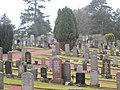 Carnwath cemetery - geograph.org.uk - 3838490.jpg 640 × 480; 73 KB
-
 Carnwath Church - geograph.org.uk - 4191621.jpg 4,000 × 3,000; 2.37 MB
-
 Carnwath From The Golf Course - geograph.org.uk - 2972809.jpg 640 × 438; 95 KB
-
 Carnwath golf course - geograph.org.uk - 6175878.jpg 1,600 × 1,060; 308 KB
-
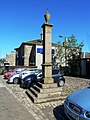 Carnwath Mercat Cross - geograph.org.uk - 2972827.jpg 480 × 640; 109 KB
-
 Carnwath Mercat Cross - geograph.org.uk - 3663540.jpg 480 × 640; 74 KB
-
 Carnwath Mill - geograph.org.uk - 6060600.jpg 3,264 × 2,448; 2.6 MB
-
 Carnwath Moss - geograph.org.uk - 3725117.jpg 640 × 480; 306 KB
-
 Carnwath Moss - geograph.org.uk - 3725128.jpg 640 × 360; 232 KB
-
 Carnwath Motte, Carnwath Golf Course - geograph.org.uk - 3663528.jpg 640 × 480; 54 KB
-
 Carnwath Parish Church - geograph.org.uk - 5768095.jpg 3,240 × 4,320; 4.3 MB
-
 Carnwath Parish Church - geograph.org.uk - 5771443.jpg 4,320 × 3,240; 3.07 MB
-

-
 Carnwath Post Office - geograph.org.uk - 2276992.jpg 640 × 480; 259 KB
-
 Carnwath War Memorial - geograph.org.uk - 1610081.jpg 425 × 640; 144 KB
-
 Carnwath War Memorial - geograph.org.uk - 2276981.jpg 640 × 480; 308 KB
-
 Carnwath War Memorial - geograph.org.uk - 6060671.jpg 3,264 × 2,448; 3.28 MB
-
 Carstairs from the air - geograph.org.uk - 2231048.jpg 2,592 × 1,944; 3.37 MB
-
 Carstairs to Edinburgh Railway - geograph.org.uk - 5538763.jpg 3,264 × 2,448; 3.39 MB
-
 Cattle grazing at Benthead - geograph.org.uk - 5580888.jpg 3,264 × 2,448; 4.8 MB
-
 Cattle Near Carnwath - geograph.org.uk - 3697433.jpg 640 × 456; 77 KB
-
 Cattle, Crofthill - geograph.org.uk - 1902438.jpg 640 × 359; 76 KB
-
 Cattle, Haywood - geograph.org.uk - 2066622.jpg 640 × 480; 78 KB
-

-
 Charolais cattle, Lampits - geograph.org.uk - 2475440.jpg 640 × 359; 211 KB
-
 Children's playground - geograph.org.uk - 1471600.jpg 640 × 483; 73 KB
-

-
 Clear felled area, Worm Law - geograph.org.uk - 2066453.jpg 640 × 480; 117 KB
-
 Clear felled area, Worm Law - geograph.org.uk - 2066464.jpg 640 × 480; 104 KB
-
 Clearing, Heathfield Forest - geograph.org.uk - 2066093.jpg 640 × 480; 108 KB
-
 Clearing, Hendry's Corse - geograph.org.uk - 2066134.jpg 640 × 359; 88 KB
-
 Cleuch Bridge - geograph.org.uk - 3654508.jpg 640 × 480; 129 KB
-
 Cleugh House Doocot - geograph.org.uk - 5580954.jpg 3,264 × 2,448; 3.44 MB
-
 Climpy Industrial Park - geograph.org.uk - 2983429.jpg 640 × 480; 246 KB
-
 Cobbinshaw Reservoir - geograph.org.uk - 3517202.jpg 3,264 × 2,448; 3.41 MB
-
 Cobbinshaw Reservoir - geograph.org.uk - 5551323.jpg 3,264 × 2,448; 2.45 MB
-
 Cobinshaw reservoir from the air - geograph.org.uk - 6157792.jpg 1,024 × 768; 302 KB
-
 Collybia maculata - geograph.org.uk - 931958.jpg 640 × 480; 131 KB
-

-

-
 Corse Law Forest Edge - geograph.org.uk - 2972921.jpg 640 × 480; 160 KB
-
 Cottage on the A70 - geograph.org.uk - 5957972.jpg 3,264 × 2,448; 2.81 MB
-
 Cottages in Forth - geograph.org.uk - 2649230.jpg 4,000 × 3,000; 1.67 MB
-
 Cottages, Main Street, Carnwath - geograph.org.uk - 6060673.jpg 3,264 × 2,448; 2.04 MB
-
 Couthalley Castle - geograph.org.uk - 2914945.jpg 640 × 480; 268 KB
-
 Covington Oval, West End, Carnwath - geograph.org.uk - 3468096.jpg 640 × 480; 60 KB
-
 Cows grazing - geograph.org.uk - 2520757.jpg 4,000 × 3,000; 3.04 MB
-
 Crofthead Wood - geograph.org.uk - 1894397.jpg 640 × 480; 111 KB
-
 Crofthill Farm - geograph.org.uk - 2521848.jpg 4,000 × 3,000; 3.82 MB
-

-
 Crosswood Hill - geograph.org.uk - 2108336.jpg 640 × 359; 64 KB
-
 Darlees Rig - geograph.org.uk - 2117336.jpg 640 × 359; 66 KB
-
 Derelict house at Haywood - geograph.org.uk - 5581000.jpg 3,264 × 2,448; 4.18 MB
-
 Dilapidated building in Carnwath - geograph.org.uk - 4847034.jpg 1,024 × 682; 162 KB
-
 Dippool Water - geograph.org.uk - 2043287.jpg 640 × 359; 96 KB
-
 Dippool Water - geograph.org.uk - 2112657.jpg 640 × 480; 125 KB
-
 Dippool Water - geograph.org.uk - 2323778.jpg 640 × 480; 230 KB
-
 Dippool Water - geograph.org.uk - 3654743.jpg 640 × 480; 78 KB
-
 Dippool Water - geograph.org.uk - 3728096.jpg 640 × 480; 282 KB
-
 Dippool Water - geograph.org.uk - 3728106.jpg 640 × 480; 333 KB
-
 Dolphinton Branch - geograph.org.uk - 2474056.jpg 640 × 480; 287 KB
-
 Doocot - geograph.org.uk - 160839.jpg 640 × 480; 138 KB
-

-
 Double shelter belt near Blackhill - geograph.org.uk - 930766.jpg 640 × 480; 101 KB
-
 Drain by Tarbrax - geograph.org.uk - 1894388.jpg 640 × 480; 127 KB
-
 Drain by Tarbrax - geograph.org.uk - 1894391.jpg 640 × 480; 162 KB
-
 Dyke south of Haywood - geograph.org.uk - 2284049.jpg 640 × 359; 189 KB
-
 East Yardhouses - geograph.org.uk - 5992105.jpg 3,264 × 2,448; 3.7 MB
-
 Easteryardhouse Hill - geograph.org.uk - 2049003.jpg 640 × 480; 96 KB
-
 Easteryardhouse Hill - geograph.org.uk - 6009209.jpg 640 × 427; 385 KB
-
 Easteryardhouse Hill - geograph.org.uk - 843829.jpg 640 × 480; 60 KB
-
 Edge of Heathfield Forest - geograph.org.uk - 2166766.jpg 640 × 480; 66 KB
-
 Electric train near Carnwath - geograph.org.uk - 6175896.jpg 1,600 × 1,060; 544 KB
-
 En Route To Hendry's Corse - geograph.org.uk - 4566282.jpg 2,560 × 1,920; 2.66 MB
-
 Entering Carnwath from the South - geograph.org.uk - 3663570.jpg 640 × 480; 55 KB
-
 Entering Woolfords Cottages - geograph.org.uk - 5580911.jpg 3,264 × 2,448; 2.92 MB
-

-
 Entrance to open-cast coal mine site - geograph.org.uk - 930722.jpg 640 × 480; 64 KB
-
 Entrance to The Wood Place - Lanarkshire Hardwoods - geograph.org.uk - 5993544.jpg 3,264 × 2,448; 4.54 MB
-
 Entrance to Woodend Moss - geograph.org.uk - 930755.jpg 640 × 480; 63 KB
-
 Esso Filling Station on Main Street - geograph.org.uk - 2494353.jpg 3,567 × 2,664; 900 KB
-
 Established woodland - geograph.org.uk - 2053979.jpg 480 × 640; 132 KB
-
 Established woodland and new plantings - geograph.org.uk - 3868751.jpg 640 × 480; 112 KB
-
 Evening on the Lang Whang - geograph.org.uk - 2119440.jpg 640 × 359; 48 KB
-
 Falla Burn valley - geograph.org.uk - 5992115.jpg 3,264 × 2,448; 5.37 MB
-
 Falla Burn valley - geograph.org.uk - 5992118.jpg 3,264 × 2,448; 4.04 MB
-
 Falla Woodland - geograph.org.uk - 3167206.jpg 640 × 480; 295 KB
-
 Farm road at Bankhead - geograph.org.uk - 5608932.jpg 1,024 × 682; 188 KB
-
 Farm sign, Haywood - geograph.org.uk - 2066617.jpg 640 × 480; 110 KB
-
 Farmland at Backmoor Wood - geograph.org.uk - 5992096.jpg 3,264 × 2,448; 3.94 MB
-
 Farmland at Kersewell - geograph.org.uk - 6060135.jpg 3,264 × 2,448; 5.32 MB
-
 Farmland at The Greens - geograph.org.uk - 6071796.jpg 3,264 × 2,448; 5.29 MB
-
 Farmland near Carnwath - geograph.org.uk - 5971632.jpg 2,592 × 1,944; 1.19 MB
-
 Farmland near Scabgill - geograph.org.uk - 1894762.jpg 640 × 480; 117 KB
-
 Farmland, Eastshield - geograph.org.uk - 1894736.jpg 640 × 359; 82 KB
-
 Farmlands of Newbigginghill - geograph.org.uk - 3764412.jpg 640 × 480; 59 KB
-
 Felled and replanted area - geograph.org.uk - 2066485.jpg 640 × 480; 99 KB
-
 Felled area - geograph.org.uk - 2066518.jpg 640 × 480; 100 KB
-
 Felled area, Heathfield Forest - geograph.org.uk - 2166775.jpg 640 × 359; 82 KB
-
 Felled area, Pate's Hill - geograph.org.uk - 2022903.jpg 640 × 480; 109 KB
-
 Felled forestry, Carnwath Moss - geograph.org.uk - 5672989.jpg 4,608 × 3,456; 4.99 MB
-
 Fence and railway bridge over the River Clyde - geograph.org.uk - 5877849.jpg 1,024 × 768; 213 KB
-
 Field boundary, Stobwood - geograph.org.uk - 1900530.jpg 640 × 359; 99 KB
-
 Field by Bertram House - geograph.org.uk - 2276899.jpg 640 × 359; 204 KB
-
 Field near Greenaton - geograph.org.uk - 6009226.jpg 640 × 427; 413 KB
-
 Field with triple bath - geograph.org.uk - 5993270.jpg 3,264 × 2,448; 4.54 MB
-
 Field, Bankhead - geograph.org.uk - 2474084.jpg 640 × 359; 226 KB
-
 Field, Greenshieldhouse - geograph.org.uk - 2116124.jpg 640 × 480; 71 KB
-
 Field, Loanhead - geograph.org.uk - 2112296.jpg 640 × 480; 95 KB
-
 Fire break in heathland Plantation near to Wilsontown - geograph.org.uk - 2519101.jpg 4,000 × 3,000; 2.93 MB
-
 Fishing pond - geograph.org.uk - 1477780.jpg 640 × 480; 73 KB
-
 Flooded field,Park - geograph.org.uk - 2277004.jpg 640 × 480; 243 KB
-
 Fly-tipping by the A70 - geograph.org.uk - 5992833.jpg 3,264 × 2,448; 6.08 MB
-
 Fodder crop at Kersewell - geograph.org.uk - 6060163.jpg 3,264 × 2,448; 4.82 MB
-
 Footbridge over the Mouse Water - geograph.org.uk - 5541071.jpg 3,264 × 2,448; 3.55 MB
-
 Footpath marker - geograph.org.uk - 1471755.jpg 480 × 640; 76 KB
-
 Ford on Mouse Water south-east of Forth - geograph.org.uk - 3654478.jpg 640 × 480; 103 KB
-
 Fording the Clyde - geograph.org.uk - 2474443.jpg 640 × 480; 287 KB
-
 Fordmouth Bridge - geograph.org.uk - 5993258.jpg 3,264 × 2,448; 4.28 MB


&filefrom=Fordmouth+Bridge+-+geograph.org.uk+-+5993263.jpg#mw-category-media)