Category:Canal Road bridge, Chester
Jump to navigation
Jump to search
| Object location | | View all coordinates using: OpenStreetMap |
|---|
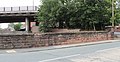
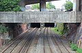
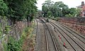
Canal Road bridge carries Canal Road over the CNH3 (Chester South Junction to Holyhead) section of the Crewe North and Holyhead Line and is 180.02 miles from the datum at Euston.
Media in category "Canal Road bridge, Chester"
The following 4 files are in this category, out of 4 total.
-
 Canal Road bridge, Chester 1.jpg 5,064 × 2,703; 9.47 MB
-
 Canal Road bridge, Chester 2.jpg 5,217 × 2,706; 11.23 MB
-
 View northeast from Canal Road bridge, Chester.jpg 4,872 × 3,174; 11.88 MB
-
 View southwest from Canal Road bridge, Chester.jpg 4,938 × 2,952; 13.03 MB


