Category:Bridge 63, Macclesfield Canal
Jump to navigation
Jump to search
| Object location | | View all coordinates using: OpenStreetMap |
|---|
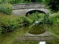
Grade II listed canal bridge in the parish of Congleton, Cheshire, England, UK  | |||||
| Upload media | |||||
| Instance of | |||||
|---|---|---|---|---|---|
| Location | Congleton, Cheshire East, Cheshire, North West England, England | ||||
| Crosses |
| ||||
| Heritage designation |
| ||||
 | |||||
Stone arch bridge over the Macclesfield Canal, Congleton, Cheshire East, Cheshire, England. Also known as Stanier 2nd Bridge.
Bridge number 63 over the Macclesfield Canal.
Media in category "Bridge 63, Macclesfield Canal"
The following 6 files are in this category, out of 6 total.
-
 Bridge No. 63, Macclesfield canal.jpg 4,160 × 3,120; 4.53 MB
-
 Bridge ^63 on the Macclesfield Canal - geograph.org.uk - 5179606.jpg 800 × 600; 232 KB
-

-
 Macclesfield Canal, Stanier 2nd Bridge No 63 - geograph.org.uk - 4419572.jpg 4,180 × 3,125; 7.18 MB
-
-


