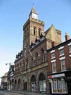
Congleton
Jump to navigation
Jump to search
town and civil parish in Cheshire East, Cheshire, England, UK | |||||
| Upload media | |||||
| Instance of | |||||
|---|---|---|---|---|---|
| Location | Cheshire East, Cheshire, North West England, England | ||||
| Population |
| ||||
| Different from | |||||
| Said to be the same as | Congleton (Wikimedia duplicated page, civil parish) | ||||
 | |||||
Photos of Congleton in Cheshire, UK.
Maps
[edit]-
Former Congleton Rural District (1894-1974)
-
Former Municipal Borough of Congleton (1970)
-
Borough of Congleton (1974-2009)
-
Cheshire East authority (2009-present)
Political
[edit]-
Congleton Constituency (2007 boundaries)
-
Congleton Constituency (2023 boundaries)
History
[edit]Main category: History of Congleton
-
1579 map of Cheshire
-
1646 map of Cheshire
-
Coat of arms of the Borough of Congleton (1878)
-
Blue plaque on Bradshaw House
-
Congleton Borough Council Mayors
-
Opening of the North Rode Viaduct in 1848
-
The disused Biddulph Valley Railway Line
Streets
[edit]Main category: Streets in Congleton
-
High Street
-
Canal Street
-
Chapel Street
-
Mountbatten Way
-
Lawton Street
-
Little Street
-
Bridge Street
-
Bridge Street
Architecture and landmarks
[edit]Main category: Buildings in Congleton
-
Congleton Town Hall
-
The Counting House
-
The Lion and Swan Hotel
-
Ye Olde Kings Arms
-
Overton House
-
43 Lawton Street
-
Danesford
-
Congleton Museum 2555.JPG
-
Brook Mills
-
St Peter's Church
-
Church of St James the Great
-
Holy Trinity Church
-
Congleton United Reformed Church
-
Trinity Methodist Church
-
Water Tower
-
The two Water Towers
-
The Congleton Steamboat
Monuments and public art
[edit]Main category: Monuments and memorials in Congleton
-
Statue of Sergeant Major George Eardley
-
Congleton War Memorial
-
Congleton Edge War Memorial
-
Statue of Elizabeth Wolstenholme Elmy
-
A Congleton bear
-
A Congleton bear
-
Buglawton Bear
-
A cow
Parks
[edit]-
Congleton Park
-
Congleton Park
-
Congleton Park
-
Congleton Park Jubilee Pavilion
Waterways
[edit]-
The River Dane at Congleton Park
-
Old Mill Weir
-
Old Mill Weir
-
Macclesfield Canal
-
Macclesfield Canal
-
Macclesfield Canal
-
Astbury Mere
Transport
[edit]Main category: Transport in Congleton
-
Congleton Station (c.1900)
-
Congleton railway station
-
Bostock's Coaches
-
North Rode Viaduct
-
Congleton Viaduct


