Category:Beeby
Jump to navigation
Jump to search
Cebuano: Beeby maoy parokya sa Hiniusang Gingharian. Ang Beeby nahimutang sa kondado sa Leicestershire ug apil sa nasod sa Inglatera, sa habagatang bahin sa nasod, ka molupyo. (→Beeby)
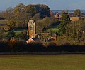
English: Beeby is a village and civil parish in the Charnwood district of Leicestershire, England, with a population of 115 according to the 2011 census. It is situated north-east of Leicester, nearer to the villages of Keyham and Hungarton in the neighbouring district of Harborough and lies along the Barkby Brook. This small rural hamlet can be succinctly described as "a series of scattered houses that remain of the shrunken medieval village". The parish also includes the hamlet of Little Beeby, which consists of several houses within the settlement and is located 200m south east of the All Saints Church. (→Beeby)
Français : Beeby est un village et une paroisse civile du Leicestershire, en Angleterre. Il est situé au nord-est de la ville de Leicester, dans le . (→Beeby)
Polski: Beeby – wieś w Anglii, w hrabstwie Leicestershire, w dystrykcie Charnwood. Leży 9 km na północny wschód od miasta Leicester i 143 km na północny zachód od Londynu. (→Beeby)
Svenska: Beeby är en parish i Storbritannien. Den ligger i grevskapet Leicestershire och riksdelen England, i den södra delen av landet. (→Beeby)

village in the United Kingdom  | |||||
| Upload media | |||||
| Instance of | |||||
|---|---|---|---|---|---|
| Location | Charnwood, Leicestershire, East Midlands, England | ||||
| Population |
| ||||
 | |||||
Subcategories
This category has the following 2 subcategories, out of 2 total.
B
- All Saints, Beeby (4 F)
L
- Little Beeby (1 F)
Media in category "Beeby"
The following 141 files are in this category, out of 141 total.
-
 All Saints Church in Beeby - geograph.org.uk - 4304803.jpg 1,600 × 1,173; 551 KB
-
 Autumn colours along Keyham Lane - geograph.org.uk - 3236467.jpg 3,791 × 2,672; 2.06 MB
-
 Autumn colours along Keyham Lane - geograph.org.uk - 3236473.jpg 4,000 × 3,000; 3.17 MB
-
 Barkby Brook crossing - geograph.org.uk - 3350027.jpg 640 × 488; 98 KB
-

-
 Barkby Road heading towards Beeby - geograph.org.uk - 3238303.jpg 4,000 × 3,000; 2.38 MB
-
 Barkby Road towards Beeby - geograph.org.uk - 3350028.jpg 640 × 457; 53 KB
-
 Beeby All Saints - geograph.org.uk - 2652832.jpg 640 × 480; 116 KB
-
 Beeby crossroads - geograph.org.uk - 3578531.jpg 640 × 473; 46 KB
-
 Beeby Grange, Croxton Road - geograph.org.uk - 5167986.jpg 3,776 × 2,520; 4.23 MB
-
 Beeby Road - Scraptoft Lane crossing Melton Brook - geograph.org.uk - 5168587.jpg 3,776 × 2,520; 4.25 MB
-
 Beeby Road towards Scraptoft - geograph.org.uk - 3350024.jpg 640 × 481; 66 KB
-
 Beeby Road towards South Croxton - geograph.org.uk - 3350025.jpg 640 × 456; 59 KB
-
 Beeby well and pump - geograph.org.uk - 5719014.jpg 1,280 × 960; 565 KB
-
 Beeby, Leicestershire - geograph.org.uk - 35594.jpg 640 × 480; 152 KB
-
 Beeby, Leicestershire population time series 1881-2011.jpg 752 × 452; 32 KB
-
 Beeby, the telephone box - geograph.org.uk - 5271376.jpg 640 × 480; 57 KB
-
 Bench mark, All Saints Church, Beeby - geograph.org.uk - 5719130.jpg 1,280 × 1,280; 881 KB
-
 Bridleway from Scraptoft Lane to Barkby Thorpe - geograph.org.uk - 5339969.jpg 4,000 × 3,000; 3.77 MB
-

-
 Brooke House Farmhouse, Beeby - geograph.org.uk - 5719992.jpg 1,280 × 1,280; 595 KB
-
 Cattle in a small field in Beeby - geograph.org.uk - 4304791.jpg 1,600 × 1,374; 757 KB
-
 Cereal crop at Little Beeby - geograph.org.uk - 5730617.jpg 1,280 × 960; 325 KB
-
 Church of All Saints - geograph.org.uk - 3236586.jpg 2,991 × 2,485; 2.17 MB
-
 Church of All Saints in Beeby - geograph.org.uk - 3236635.jpg 3,827 × 2,887; 3.12 MB
-
 Church of All Saints, Beeby - geograph.org.uk - 5719025.jpg 910 × 1,280; 327 KB
-
 Church of All Saints, Beeby - geograph.org.uk - 5719028.jpg 1,019 × 1,280; 381 KB
-
 Church of All Saints, Beeby - geograph.org.uk - 5719038.jpg 883 × 1,280; 366 KB
-
 Church of All Saints, Beeby - geograph.org.uk - 5719040.jpg 960 × 1,280; 236 KB
-
 Church of All Saints, Beeby - geograph.org.uk - 5719044.jpg 1,280 × 960; 277 KB
-
 Church of All Saints, Beeby - geograph.org.uk - 5719046.jpg 881 × 1,280; 248 KB
-
 Church of All Saints, Beeby - geograph.org.uk - 5719047.jpg 924 × 1,280; 240 KB
-
 Church of All Saints, Beeby - geograph.org.uk - 5719050.jpg 766 × 1,280; 252 KB
-
 Church of All Saints, Beeby - geograph.org.uk - 5719052.jpg 1,280 × 853; 239 KB
-
 Church of All Saints, Beeby - geograph.org.uk - 5719054.jpg 960 × 1,280; 236 KB
-
 Church of All Saints, Beeby - geograph.org.uk - 5719058.jpg 1,280 × 1,037; 346 KB
-
 Church of All Saints, Beeby - geograph.org.uk - 5719059.jpg 1,280 × 960; 303 KB
-
 Church of All Saints, Beeby - geograph.org.uk - 5719061.jpg 1,280 × 985; 298 KB
-
 Church of All Saints, Beeby - geograph.org.uk - 5719066.jpg 858 × 1,280; 270 KB
-
 Church of All Saints, Beeby - geograph.org.uk - 5719068.jpg 960 × 1,280; 329 KB
-
 Church of All Saints, Beeby - geograph.org.uk - 5719071.jpg 960 × 1,280; 288 KB
-
 Church of All Saints, Beeby - geograph.org.uk - 5719072.jpg 960 × 1,280; 238 KB
-
 Church of All Saints, Beeby - geograph.org.uk - 5719096.jpg 871 × 1,280; 253 KB
-
 Church of All Saints, Beeby - geograph.org.uk - 5719098.jpg 1,280 × 960; 315 KB
-
 Church of All Saints, Beeby - geograph.org.uk - 5719100.jpg 967 × 1,280; 381 KB
-
 Church of All Saints, Beeby - geograph.org.uk - 5719102.jpg 1,280 × 935; 366 KB
-
 Church of All Saints, Beeby - geograph.org.uk - 5719107.jpg 1,019 × 1,280; 294 KB
-
 Church of All Saints, Beeby - geograph.org.uk - 5719109.jpg 1,280 × 940; 323 KB
-
 Church of All Saints, Beeby - geograph.org.uk - 5719111.jpg 924 × 1,280; 390 KB
-
 Church of All Saints, Beeby - geograph.org.uk - 5719120.jpg 960 × 1,280; 579 KB
-
 Church of All Saints, Beeby - geograph.org.uk - 5719123.jpg 960 × 1,280; 524 KB
-
 Church of All Saints, Beeby - geograph.org.uk - 5719125.jpg 1,280 × 960; 402 KB
-
 Church of All Saints, Beeby - geograph.org.uk - 5719128.jpg 973 × 1,280; 359 KB
-
 Church of All Saints, Beeby - geograph.org.uk - 5719139.jpg 1,280 × 1,280; 506 KB
-
 Cottage Farm, Little Beeby - geograph.org.uk - 6221311.jpg 3,776 × 2,520; 3.17 MB
-
 Croxton Road towards Beeby - geograph.org.uk - 2652833.jpg 640 × 445; 71 KB
-
 Croxton Road towards Beeby - geograph.org.uk - 5119674.jpg 640 × 465; 81 KB
-
 Croxton Road towards South Croxton - geograph.org.uk - 2652834.jpg 640 × 461; 66 KB
-
 Doorway to The Manor House, Beeby - geograph.org.uk - 5719995.jpg 960 × 1,280; 454 KB
-
 Entering Beeby on Scraptoft Lane - geograph.org.uk - 5168576.jpg 3,776 × 2,520; 4.2 MB
-
 Farm access road - geograph.org.uk - 5718999.jpg 1,280 × 960; 592 KB
-
 Farm gates along Hungarton Lane - geograph.org.uk - 3815494.jpg 1,600 × 1,162; 563 KB
-
 Farmland in the Barkby Brook valley - geograph.org.uk - 3236558.jpg 4,000 × 3,000; 3.69 MB
-
 Farmland near Manor Farm - geograph.org.uk - 3236502.jpg 3,389 × 2,565; 2.73 MB
-
 Farmland north of Keyham Lane - geograph.org.uk - 3236535.jpg 3,170 × 2,617; 2.79 MB
-

-
 Field entrance - geograph.org.uk - 3350029.jpg 640 × 467; 62 KB
-

-
 Field gate on Coxton Road - geograph.org.uk - 1580263.jpg 480 × 640; 103 KB
-
 Fields by Croxton Road - geograph.org.uk - 2652835.jpg 640 × 475; 97 KB
-
 Fields north of Hungarton Lane - geograph.org.uk - 6012495.jpg 640 × 432; 49 KB
-
 Fields north of Scraptoft Lane - geograph.org.uk - 3350026.jpg 640 × 461; 61 KB
-
 Fingerpost at Beeby - geograph.org.uk - 5719996.jpg 1,280 × 960; 425 KB
-
 Footbridge over Barkby Brook - geograph.org.uk - 4744539.jpg 640 × 480; 47 KB
-
 Footpath from Beeby to Hamilton - geograph.org.uk - 5341945.jpg 4,000 × 3,000; 2.55 MB
-
 Footpath from Beeby to Hamilton - geograph.org.uk - 5342037.jpg 4,000 × 3,000; 3.63 MB
-
 Footpath to Beeby - geograph.org.uk - 5730595.jpg 1,280 × 960; 463 KB
-
 Footpath to Keyham - geograph.org.uk - 2607503.jpg 479 × 640; 100 KB
-
 Footpath to Keyham - geograph.org.uk - 5730615.jpg 1,280 × 960; 431 KB
-
 Footpath to Keyham on 14 July 2016 - geograph.org.uk - 5119685.jpg 640 × 490; 102 KB
-

-
 Footpath towards Beeby - geograph.org.uk - 3350047.jpg 640 × 468; 60 KB
-
 Footpath towards Beeby - geograph.org.uk - 3350053.jpg 640 × 473; 67 KB
-
 Footpath towards Beeby Grange - geograph.org.uk - 5645773.jpg 640 × 480; 53 KB
-
 Footpath towards Beeby Grange - geograph.org.uk - 5719999.jpg 1,280 × 960; 353 KB
-
 Footpath towards South Croxton - geograph.org.uk - 2607505.jpg 640 × 443; 72 KB
-
 Footpath towards South Croxton - geograph.org.uk - 3350048.jpg 640 × 471; 46 KB
-
 Gap in hedge and stile from Beeby side - geograph.org.uk - 5119676.jpg 640 × 478; 187 KB
-

-
 Home Farm - geograph.org.uk - 5719137.jpg 1,280 × 903; 335 KB
-
 Horse rider on Hungaton Lane - geograph.org.uk - 3815524.jpg 1,600 × 1,437; 440 KB
-
 House in the Barkby Brook valley - geograph.org.uk - 3236617.jpg 3,480 × 2,695; 2.04 MB
-
 Hungarton Lane - geograph.org.uk - 2607506.jpg 640 × 488; 72 KB
-
 Hungarton Lane - geograph.org.uk - 3578532.jpg 640 × 492; 55 KB
-
 Hungarton Lane heading towards Beeby - geograph.org.uk - 3815513.jpg 1,600 × 1,171; 439 KB
-
 Hungarton Lane heading towards Beeby - geograph.org.uk - 3815528.jpg 1,600 × 1,200; 505 KB
-
 Hungarton Lane towards Beeby - geograph.org.uk - 2607508.jpg 640 × 473; 69 KB
-
 Hungarton Lane towards Hungarton - geograph.org.uk - 6012496.jpg 640 × 398; 51 KB
-
 Inscription at Beeby well - geograph.org.uk - 5719019.jpg 1,280 × 960; 657 KB
-
 Keyham Lane - geograph.org.uk - 3350042.jpg 640 × 472; 54 KB
-
 Leicester City Skyline - geograph.org.uk - 498016.jpg 640 × 505; 88 KB
-
 Lodge Farm, Little Beeby - geograph.org.uk - 5730590.jpg 1,280 × 960; 455 KB
-
 Lodge Farm, Little Beeby - geograph.org.uk - 5730591.jpg 960 × 1,280; 628 KB
-
 Major works alongside the Barkby Brook - geograph.org.uk - 5347530.jpg 3,648 × 2,736; 2.44 MB
-
 Manor Farm viewed from Hungarton Lane - geograph.org.uk - 3815518.jpg 1,600 × 1,207; 699 KB
-
 Manor Farm, Beeby - geograph.org.uk - 5730621.jpg 1,280 × 960; 439 KB
-
 Manor House, Beeby - geograph.org.uk - 5719994.jpg 1,280 × 960; 385 KB
-

-
 Minor flooding along Hungarton Lane - geograph.org.uk - 3815539.jpg 1,600 × 1,173; 579 KB
-
 No access for motor vehicles - geograph.org.uk - 5720004.jpg 1,280 × 960; 259 KB
-
 Phone box and post box in Beeby - geograph.org.uk - 3815545.jpg 1,600 × 1,163; 709 KB
-
 Plant life on a barn wall - geograph.org.uk - 5347514.jpg 3,648 × 2,736; 2.57 MB
-
 Post Box Number LE7 91 - geograph.org.uk - 3591369.jpg 490 × 640; 109 KB
-
 Ridgemere Lane towards South Croxton - geograph.org.uk - 1204835.jpg 640 × 430; 76 KB
-
 Road junction in Beeby - geograph.org.uk - 497001.jpg 640 × 439; 94 KB
-
 Scraproft Lane descends towards Beeby - geograph.org.uk - 5342171.jpg 4,000 × 3,000; 3.4 MB
-
 Sign for Beeby along Scraptoft Lane - geograph.org.uk - 3236626.jpg 3,279 × 2,758; 2.37 MB
-
 Sign on gatepost - geograph.org.uk - 5119686.jpg 640 × 494; 124 KB
-
 Signpost in Beeby - geograph.org.uk - 2652836.jpg 640 × 547; 167 KB
-
 Spring flowers at Lodge Farm entrance - geograph.org.uk - 5730587.jpg 1,280 × 960; 652 KB
-
 Stile to Croxton Road - geograph.org.uk - 3350049.jpg 640 × 468; 84 KB
-
 Storm clouds gathering - geograph.org.uk - 498094.jpg 640 × 523; 90 KB
-
 The entrance to Stepping Stones Old Farm - geograph.org.uk - 5730588.jpg 1,280 × 960; 620 KB
-
 Towards Beeby - geograph.org.uk - 3350050.jpg 640 × 472; 54 KB
-
 Towards Beeby - geograph.org.uk - 3350054.jpg 640 × 465; 62 KB
-
 Towards Beeby - geograph.org.uk - 5119679.jpg 640 × 478; 86 KB
-

-
 Towards Leicester - geograph.org.uk - 3350044.jpg 640 × 468; 71 KB
-
 Towards Scraptoft - geograph.org.uk - 2652837.jpg 640 × 503; 111 KB
-
 Towards South Croxton - geograph.org.uk - 3350051.jpg 640 × 456; 51 KB
-
 Towards South Croxton - geograph.org.uk - 5119680.jpg 640 × 477; 118 KB
-
 Track leading to Barkby Holt - geograph.org.uk - 5720002.jpg 1,280 × 883; 348 KB
-
 Track to Manor Farm - geograph.org.uk - 6220256.jpg 3,776 × 2,520; 3.25 MB
-
 Track towards Barkby Holt - geograph.org.uk - 5167970.jpg 3,776 × 2,520; 3.83 MB
-
 View towards Ratcliffe on Soar Power Station - geograph.org.uk - 3236576.jpg 4,000 × 3,000; 3.39 MB
-
 Water pump - geograph.org.uk - 497004.jpg 640 × 606; 173 KB
-
 Welcome to Beeby - geograph.org.uk - 498097.jpg 640 × 533; 145 KB
-
 Well Head and Water Pump - geograph.org.uk - 2274514.jpg 640 × 480; 146 KB
-

-
 Main Street in Beeby - geograph.org.uk - 498101.jpg 640 × 473; 118 KB
-


