Category:Ashtree Farmhouse, Willaston
Jump to navigation
Jump to search
| Object location | | View all coordinates using: OpenStreetMap |
|---|
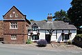
Grade II listed farmhouse in Willaston, Cheshire West and Chester, Cheshire, England, UK  | |||||
| Upload media | |||||
| Instance of | |||||
|---|---|---|---|---|---|
| Location | Willaston, Cheshire West and Chester, Cheshire, North West England, England | ||||
| Heritage designation |
| ||||
 | |||||
This is a category about listed building number 1387663. |
Media in category "Ashtree Farmhouse, Willaston"
The following 10 files are in this category, out of 10 total.
-
 Ashtree Farm plaque, Willaston.jpg 3,852 × 3,044; 6.21 MB
-
 Ashtree Farm yard, Willaston.jpg 4,780 × 3,132; 11.41 MB
-
 Ashtree Farmhouse, Willaston - cottage.jpg 5,094 × 3,322; 10.93 MB
-
 Ashtree Farmhouse, Willaston - front elev.jpg 5,145 × 3,418; 13.06 MB
-
 Ashtree Farmhouse, Willaston - persp north.jpg 4,864 × 3,271; 10.08 MB
-
 Ashtree Farmhouse, Willaston - persp south.jpg 5,007 × 3,180; 9.05 MB
-
 Datestone and oculi, Ashtree farmhouse.jpg 3,744 × 2,368; 5.14 MB
-
 Dovecote at Ashtree Farm, Willaston.jpg 4,712 × 3,328; 9.92 MB
-
 Old Cottages, Willaston - geograph.org.uk - 36675.jpg 640 × 480; 61 KB
-
 Willaston - Ashtree Farmhouse - geograph.org.uk - 474370.jpg 640 × 480; 96 KB


