Category:Aquifers in the United States
Jump to navigation
Jump to search
Wikimedia list article | |||||
| Upload media | |||||
| Instance of | |||||
|---|---|---|---|---|---|
| Location |
| ||||
| |||||
Subcategories
This category has the following 17 subcategories, out of 17 total.
Media in category "Aquifers in the United States"
The following 51 files are in this category, out of 51 total.
-
 AlapahaRiver2002.jpg 2,010 × 1,507; 641 KB
-
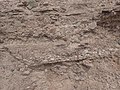 Ancha Formation close.jpg 4,000 × 3,000; 2.92 MB
-
 Aquifers - Denver Basin.png 1,175 × 950; 37 KB
-

-
 Big Spring Creek Lewistown Montana 16.JPG 3,264 × 2,448; 3.17 MB
-
 Cambrian-Ordovician Aquifer System.webp 352 × 377; 20 KB
-
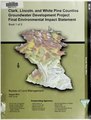 Clark, Lincoln, and White Pine Counties groundwater development project final environmental impact statement (IA clarklincolnwhit01unse).pdf 1,643 × 2,160, 872 pages; 78.81 MB
-
 Cottonwood Limestone Shrubbery Tagged.jpg 2,559 × 859; 376 KB
-
 Cottonwood Limestone Shrubbery.jpg 2,559 × 859; 356 KB
-
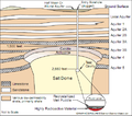 Cross section of Salmon Site.png 468 × 414; 78 KB
-
 Cross section of Salmon Site.svg 503 × 439; 298 KB
-
 An economic analysis of two groundwater allocation programs for the Salinas Valley (IA economicanalysis00luet).pdf 1,112 × 1,593, 274 pages; 11.54 MB
-
 Edwards and Trinity Aquifers Map.png 649 × 592; 206 KB
-
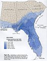
 Floridan hydrogeologic units.png 689 × 949; 165 KB
-
 Geology and underground waters of the Arkansas Valley in eastern Colorado (IA geologyundergrou00dart).pdf 1,504 × 1,985, 168 pages; 11.3 MB
-
 Geology and underground waters of northeastern Texas (IA geologyundergrou00gord).pdf 818 × 1,320, 98 pages; 6.6 MB
-
 Geology and underground waters of southern Minnesota (IA geologyundergrou00hall).pdf 866 × 1,366, 456 pages; 31.07 MB
-
 Geology and underground waters of the Wichita Region, north-central Texas (IA geologyundergrou01gord).pdf 1,100 × 1,687, 106 pages; 8.48 MB
-
 Geology and underground waters of northeastern Texas (IA geologyundergrou02gord).pdf 802 × 1,318, 98 pages; 6.96 MB
-
 Grand Canyon National Park- Redwall Limestone 0507 (7706754222).jpg 3,872 × 2,592; 2.31 MB
-
 Ground water in the Waterbury area, Connecticut (IA groundwaterinwat00elli).pdf 1,022 × 1,652, 98 pages; 7.29 MB
-
 HYDROGEOLOGY AND WATER TABLE OF THE WILLAMETTE BASIN.pdf 4,502 × 5,020; 5.36 MB
-
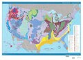
 Major US Aquifers by Rock Type.jpg 1,056 × 816; 636 KB
-
 Major US Aquifers by Rock Type.svg 990 × 765; 19.31 MB
-
 Morton Wasserspiegel.png 557 × 427; 2 KB
-
 NPS big-cypress-geologic-map.gif 2,468 × 2,844; 776 KB
-
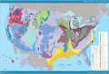
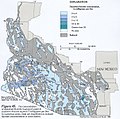
 Principal Aquifers of the United States 2008.png 938 × 592; 759 KB
-
-

-

-
-
 Snake river plain aquifer H058.jpeg 883 × 529; 156 KB
-
 Southern-Arizona-fluoride-groundwater.jpeg 603 × 597; 343 KB
-
 Summary of the underground-water resources of Mississippi (IA summaryofundergr00crid).pdf 822 × 1,312, 126 pages; 8.79 MB
-
 Summary of the underground-water resources of Mississippi (IA summaryofundergr01crid).pdf 793 × 1,295, 126 pages; 9.84 MB
-
 Suwanneelimecheese.jpg 4,032 × 3,024; 7.19 MB
-
 SVRP Aquifer Map.PNG 791 × 678; 268 KB
-
 Underground water resources of Iowa (1912) (14583586077).jpg 1,938 × 1,566; 242 KB
-
 The underground waters of southwestern Ohio (IA undergroundwater00full).pdf 800 × 1,322, 266 pages; 18.12 MB
-
 The underground water resources of the coastal plain province of Virginia (IA undergroundwater00sanf).pdf 1,214 × 1,862, 404 pages; 33.87 MB
-
 The underground water resources of Alabama (IA undergroundwater00smit).pdf 768 × 1,237, 474 pages; 28.86 MB
-
 The underground water resources of Alabama (IA undergroundwater00smitrich).pdf 770 × 1,177, 474 pages; 67.2 MB
-
 Underground waters of the coastal plain of Georgia (IA undergroundwater00step).pdf 810 × 1,329, 596 pages; 41.67 MB
-
 The underground waters of north-central Indiana (IA undergroundwater01capp).pdf 777 × 1,314, 314 pages; 22.71 MB
-
 The underground waters of southwestern Ohio (IA undergroundwater01full).pdf 800 × 1,316, 258 pages; 19.5 MB
-
 Underground water resources of Connecticut (IA undergroundwater02greg).pdf 737 × 1,272, 224 pages; 15.88 MB
-
 UnitedStates-GroundwaterAquifers-ShaleGasExtraction.svg 4,213 × 2,980; 13.25 MB
-
 Wakulla Springs Flow Rate G056.jpg 664 × 858; 120 KB
-
 Water seep from sandstone in Hanging Garden SE Utah.jpg 650 × 433; 111 KB
-
 Willamette Lowland basin-fill aquifer extent.gif 387 × 525; 24 KB
-
 Water (IA yoa1955).pdf 1,275 × 1,650, 830 pages; 52.32 MB


.jpg)


_(14583586077).jpg)


