Category:Anthropomorphic maps
Jump to navigation
Jump to search
Media in category "Anthropomorphic maps"
The following 39 files are in this category, out of 39 total.
-
 1895 pictorial map of North America as Uncle Sam.jpg 2,703 × 3,834; 2.05 MB
-
 1904 Kisaburō Ohara Satirical Octopus Map of Asia and Europe.jpg 6,000 × 4,488; 6.63 MB
-
 Carte des états désunis d'Europe - Kungliga Biblioteket - 10348540-thumb.png 10,307 × 7,703; 382.93 MB
-
 Carte des états désunis d'Europe - Kungliga Biblioteket - 10348540.tif 10,307 × 7,703, 2 pages; 454.33 MB
-
 Carte drôlatique d'Europe pour 1870.jpg 5,287 × 4,231; 5.28 MB
-
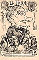 Charles Liozu Le Tarn.jpg 675 × 1,040; 547 KB
-
 Collection des Cent N° 14 (Baer).jpg 1,571 × 1,004; 316 KB
-
 Das heutige Europa - T.B. LCCN2009631645.tif 1,536 × 1,015; 1.49 MB
-
 Europa geografico-politica mappa satirica 1871 circa.jpg 4,339 × 3,149; 2.46 MB
-
 Europa Volgens de nieuwste Verdeeling.jpg 4,292 × 5,870; 7.07 MB
-
 Fred W Rose Angling in troubled waters.jpg 3,947 × 2,828; 2.97 MB
-
 Fred. W. Rose The Avenger An Allegorical War Map for 1877 1877 Cornell CUL PJM 1080 01.jpg 9,002 × 7,137; 12.83 MB
-

-
 Geography 045 - 1914 Satirical Map of Europe - 1.jpg 950 × 705; 176 KB
-
 Geography 058 - 1914 Satirical Map of Europe - 3.jpg 1,503 × 1,073; 448 KB
-
 Geography 078 - 1830 Satirical Map of Europe.jpg 2,562 × 3,600; 1.33 MB
-
 Geography 080 - Pictorial Atlas Denmark.jpg 750 × 914; 509 KB
-
 Geography 081 - Pictorial Atlas England.jpg 750 × 926; 574 KB
-
 Geography 082 - Pictorial Atlas France.jpg 750 × 922; 548 KB
-
 Geography 083 - Pictorial Atlas Germany.jpg 750 × 922; 550 KB
-
 Geography 084 - Pictorial Atlas Holland Belgium.jpg 750 × 919; 488 KB
-
 Geography 085 - Pictorial Atlas Prussia.jpg 750 × 612; 345 KB
-
 Geography 086 - Pictorial Atlas Russia.jpg 750 × 918; 517 KB
-
 Geography 087 - Pictorial Atlas Scotland.jpg 750 × 916; 634 KB
-
 Geography 088 - Pictorial Atlas Spain Portugal.jpg 750 × 604; 390 KB
-
 Geography Bewitched - Scotland.jpg 4,117 × 5,214; 7.38 MB
-

-

-
 Humoristische Karte Europa 1870.jpg 3,555 × 3,049; 5.61 MB
-
 John Bull and his Friends 1900.jpg 8,439 × 5,943; 15.22 MB
-
 Latest war map of Europe - as seen through French eyes LOC 2010587001.jpg 5,300 × 3,958; 3.23 MB
-
 Latest war map of Europe - as seen through French eyes LOC 2010587001.tif 5,300 × 3,958; 60.02 MB
-
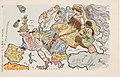
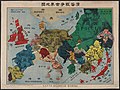 Pictorial map of World War I in Russian.jpg 7,308 × 5,505; 14.99 MB
-
 Rusofob pic8.jpg 600 × 442; 48 KB
-
 Satirical Europe in 1870.jpg 1,119 × 715; 265 KB
-
 Satirical Map of Europe, 1887.jpg 1,479 × 921; 369 KB
-
 Satirical map of Europe, 1914.jpg 1,525 × 1,117; 332 KB
-
 Serio-comic war map for 1877.jpg 8,440 × 6,448; 13.21 MB
-
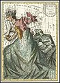
 The figure of a woman representing the map of Scotland. Etch Wellcome V0040811.jpg 2,409 × 2,939; 3.84 MB


.jpg)


.jpg)
.jpg)


