Category:Aerial photographs of the Democratic Republic of the Congo
Jump to navigation
Jump to search
Countries of Africa: Algeria · Angola · Benin · Botswana · Burkina Faso · Burundi · Cameroon · Cape Verde · Central African Republic · Chad · Democratic Republic of the Congo · Djibouti · Egypt‡ · Equatorial Guinea · Eritrea · Ethiopia · The Gambia · Ghana · Guinea · Guinea-Bissau · Ivory Coast · Kenya · Lesotho · Liberia · Libya · Madagascar · Malawi · Mali · Mauritania · Mauritius · Morocco · Mozambique · Namibia · Niger · Nigeria · Rwanda · São Tomé and Príncipe · Senegal · Seychelles · Sierra Leone · Somalia · South Africa · South Sudan · Sudan · Tanzania · Togo · Tunisia · Uganda · Zambia · Zimbabwe
Limited recognition: Somaliland – Other areas: Canary Islands · Madeira · Mayotte · Réunion · Western Sahara
‡: partly located in Africa
Limited recognition: Somaliland – Other areas: Canary Islands · Madeira · Mayotte · Réunion · Western Sahara
‡: partly located in Africa
Subcategories
This category has the following 7 subcategories, out of 7 total.
Media in category "Aerial photographs of the Democratic Republic of the Congo"
The following 33 files are in this category, out of 33 total.
-
 20180531 View from the top of Mt. Kahuzi in Kahuzi-Biega National Park.jpg 4,898 × 3,265; 1.03 MB
-

-
 Aerial photograph of Kamako (7175515946).jpg 5,616 × 3,744; 6.84 MB
-
 Aerial photograph of Kamako (7175516038).jpg 5,616 × 3,744; 4.17 MB
-
 Calendar 2016 - 09 (20868511043).jpg 5,760 × 3,840; 648 KB
-
 Changing land use in the Masisi - Julien Harneis - May 2 2007 - 1.jpg 3,008 × 2,000; 3.22 MB
-
 Changing land use in the Masisi - Julien Harneis - May 2 2007 - 2.jpg 3,008 × 2,000; 3.02 MB
-
 Changing land use in the Masisi - Julien Harneis - May 2 2007 - 4.jpg 3,008 × 2,000; 2.83 MB
-
 Congolese elephant herd, Belgian Congo.jpg 394 × 443; 52 KB
-
 Deep in Congo's Heart.jpg 6,720 × 4,480; 8.09 MB
-
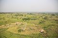
 Farmer hut in Great Rift Valley (20441317013).jpg 5,760 × 3,840; 2.29 MB
-
 Farmer hut in Great Rift Valley (21070002211).jpg 5,760 × 3,840; 1.83 MB
-
 Farmer hut in middle of palm oil trees (21052446662).jpg 5,760 × 3,840; 1.87 MB
-
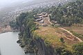 FIB site in Sake about 10 km from Goma.jpg 5,760 × 3,840; 6.98 MB
-
 Garamba National Park overhead.jpg 700 × 466; 41 KB
-
 Gbadolite mobutu palace site.jpg 720 × 546; 67 KB
-
 Great Rift valley (20441332803).jpg 5,760 × 3,840; 1 MB
-
 Ituri hills (20874693728).jpg 5,760 × 3,840; 1.22 MB
-
 Kahuzi-Biega National Park (39423247372).jpg 1,920 × 1,080; 398 KB
-
 KINGATOKO.jpg 3,264 × 1,836; 1.53 MB
-
 Lake nearby Goma - North Kivu (21062515095).jpg 5,760 × 3,840; 1.59 MB
-
 Lava flows around Goma (501946392).jpg 2,000 × 3,008; 4.05 MB
-
 Lualaba.jpg 3,024 × 4,032; 10.47 MB
-
 Nyamulagira04 (8447214999).jpg 1,250 × 625; 728 KB
-

-
 Photo of the day 21.10.20156 (22853989790).jpg 5,760 × 3,840; 1.2 MB
-
 PoolMalebo.jpg 2,112 × 2,816; 1.9 MB
-
 Rainforest - Ituri (20874628148).jpg 5,760 × 3,840; 2.3 MB
-
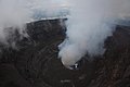
 Small volcano crater - Virunga National Park (20441498883).jpg 5,760 × 3,840; 1.39 MB
-
 Small volcano crater - Virunga National Park (21052633532).jpg 5,760 × 3,840; 1.16 MB
-
 Tshikapa 2022.jpg 1,069 × 514; 151 KB
-
 View of the peaks of the Ruwenzori chain.jpg 5,760 × 3,840; 1.18 MB
-
 Village in Great Valley Rift (20439816674).jpg 5,760 × 3,840; 2 MB

._(16964181555).jpg)
.jpg)
.jpg)
.jpg)


.jpg)
.jpg)
.jpg)


.jpg)
.jpg)
.jpg)

.jpg)
.jpg)

.jpg)
.jpg)
.jpg)

.jpg)
.jpg)
.jpg)


.jpg)