Category:Aerial photographs of Terschelling
Jump to navigation
Jump to search
Ameland · Amrum · Baltrum · Borkum · Föhr · Heligoland · Hallig Hooge · Juist · Kachelotplate · Langeneß · Langeoog · Lütje Hörn · Memmert · Minsener Oog · Norderney · Nordstrand · Pellworm · Schiermonnikoog · Spiekeroog · Sylt · Terschelling · Texel · Trischen · Vlieland · Wangerooge ·
Nederlands: Luchtfoto van Terschelling
Media in category "Aerial photographs of Terschelling"
The following 10 files are in this category, out of 10 total.
-
 Dutch Airforce 1981 DF-SC-82-11052.jpg 3,000 × 2,115; 1.28 MB
-
 FA123 (8171758462).jpg 2,476 × 1,646; 1.53 MB
-
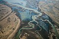
 Fresh water finding it's way way into the see east side of Terschelling (20319295221).jpg 5,616 × 3,744; 1.39 MB
-
 Luchtfoto van het dorp West-Terschelling, Bestanddeelnr 920-4915.jpg 3,703 × 2,455; 1.84 MB
-
 Luchtfoto, SFA022813622.jpg 3,541 × 2,483; 1.37 MB
-

-

-
 Perkweg, 8897 Oosterend Terschelling, Netherlands - panoramio.jpg 3,078 × 1,970; 545 KB
-
 Terschelling 5.35765E 53.40913N.jpg 1,280 × 958; 121 KB
-
 Water finding its way on the island of Terschelling, Holland (9443488030).jpg 3,888 × 2,592; 1.08 MB

.jpg)
.jpg)


.jpg)