Category:Aerial photographs of Landkreis Sächsische Schweiz-Osterzgebirge
Jump to navigation
Jump to search
Districts of Saxony:
Subcategories
This category has the following 5 subcategories, out of 5 total.
Media in category "Aerial photographs of Landkreis Sächsische Schweiz-Osterzgebirge"
The following 90 files are in this category, out of 90 total.
-
 Aerial image of the Bastei.jpg 5,400 × 3,600; 6.31 MB
-
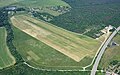 Aerial image of the Pirna-Pratzschwitz airfield.jpg 4,800 × 3,000; 5.92 MB
-
 Barockgarten Großsedlitz 01.jpg 4,032 × 2,268; 2.55 MB
-
 Barockgarten Großsedlitz 01a.jpg 1,068 × 691; 346 KB
-
 Barockgarten Großsedlitz 02.jpg 4,032 × 2,268; 2.04 MB
-
 Burg Stolpen in Sachsen.jpg 1,920 × 1,080; 2.24 MB
-
 Capron Neustadt Sachsen 01.jpg 4,032 × 2,268; 2.88 MB
-
 Capron Neustadt Sachsen 02.jpg 4,032 × 2,268; 2.15 MB
-
 Dippoldiswalde Luftbild 161-6117 IMG.jpg 1,024 × 768; 300 KB
-
 Elbsandsteingebirge Nationalpark Saechsische Schweiz Lilienstein Luftbild.jpg 3,928 × 2,037; 3.49 MB
-
 Elbsandsteingebirge Pfaffenstein spheric 360x180deg air panorama 1.jpg 12,282 × 6,141; 13.28 MB
-
 Elbsandsteingebirge Pfaffenstein spheric 360x180deg air panorama 2.jpg 12,278 × 6,139; 14.68 MB
-
 Fotothek df roe-neg 0002471 001 Blick auf Halbestadt.jpg 800 × 547; 194 KB
-
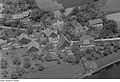 Fotothek df roe-neg 0002471 002 Blick auf Halbestadt.jpg 800 × 548; 194 KB
-
 Freital Pesterwitz Aerial Pan.jpg 11,546 × 3,623; 28.81 MB
-
 Freital Pesterwitz Aerial.jpg 3,921 × 2,139; 6.63 MB
-
 Freital, Windberg, Oberdöhlen, Weißig Luftaufnahme sept2016 - 9.jpg 2,336 × 4,160; 1.96 MB
-
 Jugenderholungsheim Endlerkuppe 01.jpg 4,032 × 2,268; 2.32 MB
-
 Jugenderholungsheim Endlerkuppe 02.jpg 4,032 × 2,268; 2.1 MB
-
 Karrenberg Neustadt in Sachsen 01.jpg 4,032 × 2,268; 1.6 MB
-
 Karrenberg Neustadt in Sachsen 02.jpg 4,032 × 2,268; 1.68 MB
-
 Lohmen Feldbahnmuseum Aerial Pan360.jpg 13,438 × 6,719; 52.68 MB
-
 Lohmen Feldbahnmuseum Aerial.jpg 5,472 × 3,648; 19.47 MB
-
 Luftbild 044 Mohorn-Grund.jpg 2,414 × 3,456; 871 KB
-
 Luftbild 046 Tharandter Wald Landberg.jpg 3,456 × 2,592; 4.56 MB
-
 Luftbild 059 Freital-Somsdorf.jpg 3,456 × 2,592; 4.25 MB
-
 Luftbild 060 Freital.jpg 2,494 × 2,592; 709 KB
-
 Luftbild 063 Rabenau-Waldfrieden Lübau Borlas.jpg 2,592 × 3,456; 4.72 MB
-
 Luftbild 067 Rabenau-Obernaundorf.jpg 2,592 × 3,456; 4.72 MB
-
 Luftbild 068 Rabenau-Oelsa.jpg 3,456 × 2,592; 4.07 MB
-
 Luftbild 069 Rabenau-Oelsa Dippoldiswalde-Seifersdorf.jpg 3,456 × 2,216; 828 KB
-
 Luftbild 070 Possendorf 1.jpg 3,456 × 2,592; 5.59 MB
-
 Luftbild 071 Possendorf 2.jpg 2,592 × 3,456; 4.76 MB
-
 Luftbild 072 Kreischa-Brösgen Kleincarsdorf Quohren.jpg 3,456 × 2,592; 4.41 MB
-
 Luftbild 073 Babisnau.jpg 2,592 × 3,456; 4.78 MB
-
 Luftbild 074 Kreischa-Bärenklause Kautzsch Kleba Theisewitz Zscheckwitz.jpg 3,456 × 2,592; 4.71 MB
-
 Luftbild 075 Kreischa-Kautzsch Gombsen.jpg 3,456 × 2,592; 4.83 MB
-
 Luftbild 076 Dohna-Burgstädtel.jpg 3,456 × 2,592; 5.15 MB
-
 Luftbild 077 Dohna-Borthen.jpg 2,592 × 3,456; 5.42 MB
-
 Luftbild 079 Heidenau-Wölkau Dohna.jpg 3,456 × 2,592; 4.86 MB
-
 Luftbild 082 Heidenau-Gommern Meuscha.jpg 3,456 × 2,592; 4.89 MB
-
 Luftbild 083 Heidenau.jpg 3,456 × 2,592; 4.97 MB
-
 Luftbild 255 Mohorn.jpg 3,456 × 2,592; 4.63 MB
-
 Luftbild 256 OPAL 1.jpg 2,592 × 3,456; 4.48 MB
-
 Luftbild 271 OPAL 2.jpg 2,592 × 3,456; 3.83 MB
-
 Luftbild Bastei 01.jpg 4,032 × 2,268; 3.14 MB
-
 Luftbild Bastei 02.jpg 4,032 × 2,268; 3.22 MB
-
 Luftbild Bastei 03.jpg 4,032 × 2,268; 3.12 MB
-
 Luftbild Bastei 04.jpg 4,032 × 2,268; 2.16 MB
-
 Luftbild Bastei 05.jpg 4,032 × 2,268; 3.13 MB
-
 Luftbild Bastei 06.jpg 4,032 × 2,268; 2.24 MB
-
 Luftbild Bastei 07.jpg 4,032 × 2,268; 2.12 MB
-
 Luftbild Dorf Wehlen.jpg 4,032 × 2,268; 1.69 MB
-
 Luftbild Elbschleife vom Königstein 01.jpg 4,032 × 2,268; 1.81 MB
-
 Luftbild Elbschleife vom Königstein 02.jpg 4,032 × 2,268; 2.81 MB
-
 Luftbild Elbschleife vom Königstein 03.jpg 4,032 × 2,268; 2.21 MB
-
 Luftbild Hafen Prossen.jpg 4,032 × 2,268; 1.98 MB
-
 Luftbild Linienstein 01.jpg 4,032 × 2,268; 2.64 MB
-
 Luftbild Linienstein 02.jpg 4,032 × 2,268; 2.52 MB
-
 Luftbild Stolpen 01.jpg 4,032 × 2,268; 3.05 MB
-
 Luftbild Stolpen 02.jpg 4,032 × 2,268; 2.23 MB
-
 Luftbild Stolpen 03.jpg 4,032 × 2,268; 2.2 MB
-
 Luftbild Stolpen 04.jpg 4,032 × 2,268; 2.23 MB
-
 Luftbild Stolpen 05.jpg 4,032 × 2,268; 3.1 MB
-
 Luftbild Stolpen 06.jpg 4,032 × 2,268; 2.22 MB
-
 Luftbild Stolpen 07.jpg 4,032 × 2,268; 2.23 MB
-
 Luftbild Stolpen 08.jpg 4,032 × 2,268; 2.9 MB
-
 Luftbild Sächsische Schweiz 01.jpg 4,032 × 2,268; 1.98 MB
-
 Luftbild Sächsische Schweiz 02.jpg 4,032 × 2,268; 1.88 MB
-
 Luftbild Sächsische Schweiz 03.jpg 4,032 × 1,920; 1.67 MB
-
 Luftbild Sächsische Schweiz 04.jpg 4,032 × 2,140; 2.3 MB
-
 Luftbild Sächsische Schweiz 05.jpg 4,032 × 2,268; 2.48 MB
-
 Luftbild Sächsische Schweiz 06.jpg 4,032 × 2,268; 2.27 MB
-
 Luftbild Sächsische Schweiz 07.jpg 4,032 × 2,268; 3.65 MB
-
 Luftbild Sächsische Schweiz 08.jpg 4,032 × 2,268; 3.96 MB
-
 Luftbild Sächsische Schweiz 09.jpg 4,032 × 2,268; 2.14 MB
-
 Steinlabyrinth Nikolsdorfer Wände 10-2020.jpg 3,456 × 4,608; 15.39 MB
-
 Talsperre Klingenberg und Ort Klingenberg Luftaufnahme sept2016 - 6.jpg 2,336 × 4,160; 1.75 MB
-
 Talsperre Lehnmühle Aerial alt.jpg 4,000 × 2,250; 7.12 MB
-
 Talsperre Lehnmühle Aerial alt1.jpg 4,000 × 2,250; 6.72 MB
-
 Talsperre Lehnmühle Aerial alt2.jpg 4,000 × 2,250; 7.14 MB
-
 Talsperre Lehnmühle Aerial alt3.jpg 4,000 × 2,250; 6.8 MB
-
 Talsperre Lehnmühle Aerial alt4.jpg 4,000 × 2,250; 6.88 MB
-
 Talsperre Lehnmühle Aerial alt5.jpg 4,000 × 2,250; 7.65 MB
-
 Talsperre Lehnmühle Aerial alt6.jpg 2,250 × 4,000; 7.08 MB
-
 Talsperre Lehnmühle Aerial Pan alt.jpg 6,958 × 4,061; 21.01 MB
-
 Talsperre Lehnmühle Aerial Pan alt2.jpg 7,111 × 3,602; 20.37 MB
-
 Talsperre Lehnmühle Aerial Pan.jpg 6,030 × 3,354; 15.44 MB
-
 Talsperre Lehnmühle Aerial.jpg 4,000 × 2,250; 7.15 MB
-
 Talsperre Malter Luftbild.jpg 951 × 646; 178 KB


