Category:Aerial photographs of Landkreis Peine
Jump to navigation
Jump to search

Deutsch: Luftbilder aus dem Landkreis Peine, Niedersachsen
Subcategories
This category has only the following subcategory.
P
- Aerial photographs of Peine (1 F)
Media in category "Aerial photographs of Landkreis Peine"
The following 9 files are in this category, out of 9 total.
-
 Aerial image of the Peine-Glindbruchkippe airfield.jpg 4,000 × 3,000; 3.6 MB
-
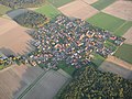
 Barbecke.jpg 3,072 × 2,304; 2.11 MB
-
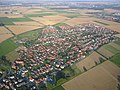
 Bodenstedt.jpg 3,072 × 2,304; 1.88 MB
-
 Broistedt.jpg 1,600 × 1,200; 648 KB
-
 Gadenstedt, Freibad am Bolzberg.JPG 2,592 × 1,944; 1.35 MB
-
 Luftaufnahme von Gadenstedt mit St.-Andreas-Kirche.jpg 774 × 512; 55 KB
-
 Luftbild Groß Ilsede Schulzentrum.JPG 2,592 × 1,166; 718 KB
-
 SBF Standort Peine um 1950.jpg 1,865 × 1,807; 1.22 MB
-
 Sierße.jpg 3,072 × 2,304; 1.63 MB


