Category:Aerial photographs of Ibaraki prefecture
Jump to navigation
Jump to search
| Prefectures of Japan | |||
|---|---|---|---|
| Hokkaido | Aomori · Iwate · Miyagi · Akita · Yamagata · Fukushima · Ibaraki · Tochigi · Gunma · Saitama · Chiba · Tokyo · Kanagawa · Niigata · Toyama · Ishikawa · Fukui · Yamanashi · Nagano · Gifu · Shizuoka · Aichi · Mie · Shiga · Kyoto · Osaka · Hyogo · Nara · Wakayama · Tottori · Shimane · Okayama · Hiroshima · Yamaguchi | Tokushima · Kagawa · Ehime · Kōchi | Fukuoka · Saga · Nagasaki · Kumamoto · Ōita · Miyazaki · Kagoshima · Okinawa | 
| ||
Subcategories
This category has the following 7 subcategories, out of 7 total.
Media in category "Aerial photographs of Ibaraki prefecture"
The following 74 files are in this category, out of 74 total.
-
 003 Ibaraki Airport, Japan - 百里飛行場-百里基地.JPG 1,920 × 752; 479 KB
-
 110319-F-PM645-435 36AS C-130 cockpit in flight from Yokota to Hyakuri.jpg 3,000 × 2,000; 3.92 MB
-
 20101210筑波山塊.jpg 1,400 × 424; 227 KB
-
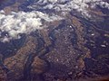
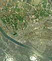
 Aerial Photography (Kasumigaura, Ibaraki, Japan) (6853759064).jpg 2,573 × 1,715; 3.87 MB
-
 Awayama aerial.jpg 1,704 × 2,272; 1.33 MB
-
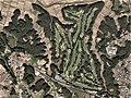
 Central Golf Club, Namegata Ibaraki Aerial photograph.2010.jpg 4,138 × 3,104; 3.87 MB
-
 Chiyoda Country Club, Kasumigaura Ibaraki Aerial photograph.2008.jpg 3,722 × 2,792; 4.33 MB
-
 D PARC.jpg 3,648 × 2,736; 4.02 MB
-
 Daioin elem.jpg 1,566 × 1,244; 1.22 MB
-
 EK 318 flight Dubai Tokyo 11 may 2024 5.jpg 5,472 × 3,648; 12.41 MB
-
 EK 318 flight Dubai Tokyo 11 may 2024 6.jpg 5,472 × 3,648; 12.93 MB
-
 F-GZCL FLIGHT NRT-CDG (7354216850).jpg 2,751 × 1,832; 3.53 MB
-
 Fanuc Tsukuba factry.jpg 3,648 × 2,736; 9.94 MB
-
 Fuso Country Club, Kasama Ibaraki Aerial photograph.2012.jpg 3,389 × 2,541; 3.04 MB
-
 Grand Slam Country Club, Hitachiota Ibaraki Aerial photograph.2012.jpg 4,711 × 3,533; 5.95 MB
-
 Hitachi areal photo.jpg 2,110 × 786; 582 KB
-
 Hitachi-Taga aerial.jpg 2,269 × 1,212; 968 KB
-
 Hitachiomiya aerial.jpg 2,272 × 1,704; 1.1 MB
-
 Hitachiota city center area Aerial photograph.2012.jpg 7,204 × 7,992; 41.5 MB
-
 Hitachiota-Ibaraki.jpg 2,272 × 1,704; 1.21 MB
-
 Ibaraki Golf Club, Tsukubamirai Ibaraki Aerial photograph.2008.jpg 3,993 × 3,755; 5.09 MB
-
 Inashiki-higashi IC 26-May-2018.jpg 3,884 × 3,108; 1.85 MB
-
 Ishioka city center area Aerial photograph.2019.jpg 11,526 × 7,754; 79.27 MB
-
 Itako city center area Aerial photograph.2019.jpg 8,402 × 9,696; 56.3 MB
-
 Itako Country Club, Itako Ibaraki Aerial photograph.1999.jpg 1,788 × 1,341; 1.05 MB
-
 JARI Proving Ground.jpg 4,608 × 3,456; 4.11 MB
-
 Jurisat Test Centre Japan Auotmobile Test Centre.jpg 2,272 × 1,704; 1.24 MB
-
 Kandatsu aerial.jpg 2,272 × 1,704; 1.35 MB
-
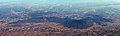
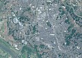
 Kanto Plain (1257569801).jpg 3,008 × 2,000; 2.02 MB
-
 Kasama aerial.jpg 2,272 × 1,316; 881 KB
-
 Kasama city center area Aerial photograph.2019.jpg 8,132 × 8,031; 49.99 MB
-
 Kasama-west aerial.jpg 2,272 × 1,704; 1.37 MB
-
 Kashitetsu Tamatsukurimachi Station 1974.jpg 1,082 × 868; 258 KB
-
 Katsuta Golf Club, Hitachinaka Ibaraki Aerial photograph.2012.jpg 3,372 × 2,529; 3.2 MB
-
 Kenkyu-Gakuen Aerial.jpg 2,272 × 1,704; 1.29 MB
-
 Kinu River Tone River junction aerial.jpg 2,272 × 1,704; 1.26 MB
-
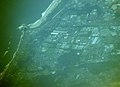 Kitaibaraki aerial.jpg 1,911 × 1,389; 1.13 MB
-
 Koga, Ibaraki city center area Aerial photograph.2021.jpg 9,904 × 8,731; 65.11 MB
-
 Koga-joshi-aerophotograph.png 660 × 944; 1.7 MB
-
 Koga-joushi-aerophotograph.png 603 × 922; 1.4 MB
-
 Koiki Sports Park.png 1,185 × 948; 2.4 MB
-
 Kokai River Ichinodai aerial.jpg 2,272 × 1,704; 1.24 MB
-
 Kokai River Tone River aerial.jpg 2,272 × 1,704; 1.26 MB
-
 KokaiRiver Moriya aerial.jpg 2,272 × 1,704; 1.21 MB
-
 KujiRiver-NakaFunyu-look south.jpg 2,272 × 1,704; 1.27 MB
-
 Marumatsu-Tepco aerial.jpg 2,272 × 1,704; 1.28 MB
-
 Mase-Midorino-Kubota aerial.jpg 2,272 × 1,704; 1.3 MB
-
 Mito city center area Aerial photograph.2022.jpg 14,420 × 15,000; 103.05 MB
-
 Mito kouku haisuitou 19750113 L.jpg 498 × 601; 165 KB
-
 Mito watari 20121013 3.jpg 435 × 481; 99 KB
-
 Mitsukaido aerial.jpg 2,272 × 1,704; 1.39 MB
-
 Moriya city center area Aerial photograph.2021.jpg 9,941 × 7,060; 54.18 MB
-
 North nuclear precint near Shirosato aerial.jpg 2,272 × 1,704; 1.61 MB
-
 NRT Nov08 008-3.jpg 1,419 × 949; 234 KB
-
 Oarai Golf Club, Oarai Ibaraki Aerial photograph.2012.jpg 4,103 × 3,077; 4.47 MB
-
 Ohtone Country Club, Bando Ibaraki Aerial photograph.2008.jpg 3,304 × 2,478; 3.23 MB
-
 Otsu aerial photo.jpg 2,272 × 1,704; 2.76 MB
-
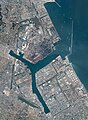 Port of Kashima Aerial photograph.2012.jpg 10,964 × 14,999; 80.63 MB
-
 Ryugasaki Country Club, Ryugasaki Ibaraki Aerial photograph.2013.jpg 2,713 × 2,035; 2.08 MB
-
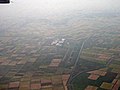
 Ryugasaki.airfield.aerialshoot.jpg 3,648 × 2,736; 5.74 MB
-
 Ryugasaki.airfield.jpg 3,648 × 2,736; 4.97 MB
-
 Ryugasaki.airfield2.jpg 3,648 × 2,736; 3.79 MB
-
 Shimada K2012-MtKaba~MtTsukuba soaring DSC08277.jpg 2,592 × 1,944; 797 KB
-
 Shimotsuma city center area Aerial photograph.2021.jpg 7,188 × 7,714; 36.68 MB
-
 Takahagi city center area Aerial photograph.2019.jpg 10,541 × 7,300; 75.81 MB
-
 The Golf Club Ryugasaki, Ryugasaki Ibaraki Aerial photograph.2013.jpg 2,942 × 2,206; 2.46 MB
-
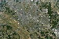
 Toride city center area Aerial photograph.2019.jpg 8,945 × 8,057; 50.89 MB
-
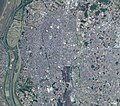
 Tsukuba aerial.jpg 2,272 × 1,704; 1.46 MB
-
 Ushikunuma aerial shoot.jpg 3,648 × 2,736; 6.19 MB
-
 Yamata transmitting station.jpg 2,995 × 2,246; 3.55 MB
-
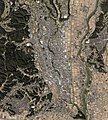
 Yuki city center area Aerial photograph.2021.jpg 9,882 × 7,658; 53.02 MB
-
 Yuki city Yuki junior high school Aerial view (1974-12).jpg 1,230 × 820; 896 KB
-
 Yuki city Yuki junior high school Aerial view (2021-05).png 1,200 × 800; 1.78 MB
-
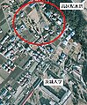
 桜川筑西IC航空写真.png 494 × 457; 450 KB

_(6853759064).jpg)


.jpg)


.jpg)


.jpg)
.png)
