Category:Abdie
Jump to navigation
Jump to search
Scottish parish in Fife, Scotland, UK | |||||
| Upload media | |||||
| Instance of | |||||
|---|---|---|---|---|---|
| Part of |
| ||||
| Location |
| ||||
| Population |
| ||||
| Area |
| ||||
 | |||||
Media in category "Abdie"
The following 173 files are in this category, out of 173 total.
-
 'Berry Choille' well - geograph.org.uk - 3986967.jpg 4,608 × 3,456; 3.12 MB
-
 A path through the reeds - geograph.org.uk - 3352337.jpg 640 × 452; 395 KB
-

-
 A913 and old railway - geograph.org.uk - 5869838.jpg 5,184 × 3,888; 6.23 MB
-
 Abdie and Dunbog Church - geograph.org.uk - 5209438.jpg 640 × 480; 120 KB
-
 Abdie Church, Grange of Lindores - geograph.org.uk - 6340947.jpg 640 × 427; 117 KB
-
 Abdie ^ Dunbog Kirk - geograph.org.uk - 5869846.jpg 5,184 × 3,888; 6.67 MB
-
 Arable land north of Berryhill - geograph.org.uk - 3987703.jpg 4,608 × 3,456; 3.34 MB
-
 Arable land, Pitcairlie - geograph.org.uk - 3567663.jpg 640 × 480; 287 KB
-
 B936 near Ormiston - geograph.org.uk - 5869835.jpg 5,184 × 3,888; 5.79 MB
-
 Barley in the sunshine - geograph.org.uk - 4131276.jpg 2,048 × 1,536; 615 KB
-
 Barley, Easter Lumbennie - geograph.org.uk - 3844733.jpg 640 × 360; 200 KB
-
 Barley, Golden Hill - geograph.org.uk - 2548364.jpg 640 × 480; 289 KB
-
 Barley, Grange of Lindores - geograph.org.uk - 2548389.jpg 640 × 480; 281 KB
-
 Barley, Ormiston - geograph.org.uk - 2548391.jpg 640 × 480; 239 KB
-

-

-
 Bend in the forestry road - geograph.org.uk - 2383914.jpg 2,560 × 1,920; 1.44 MB
-
 Berryhill cottage - geograph.org.uk - 3987495.jpg 4,608 × 3,456; 3.35 MB
-
 Berryhill farm and houses - geograph.org.uk - 2059706.jpg 640 × 480; 67 KB
-
 Berryhill Farm Cottages - geograph.org.uk - 4412695.jpg 1,066 × 800; 210 KB
-
 Berryhill steading development - geograph.org.uk - 2383853.jpg 2,560 × 1,920; 1.08 MB
-
 Black Hill - geograph.org.uk - 4600658.jpg 2,560 × 1,920; 2.68 MB
-
 Black Hill - geograph.org.uk - 4600659.jpg 2,560 × 1,920; 2.79 MB
-
 Black Loch - geograph.org.uk - 3282236.jpg 640 × 480; 122 KB
-
 Black Loch - geograph.org.uk - 4210717.jpg 3,329 × 4,749; 5.6 MB
-
 Black Loch - geograph.org.uk - 4412702.jpg 1,066 × 800; 276 KB
-
 Black Loch by Lindores - geograph.org.uk - 4210739.jpg 768 × 1,024; 188 KB
-
 Blossom in Berryhill - geograph.org.uk - 2383866.jpg 2,560 × 1,920; 1.34 MB
-
 Braeside of Lindores - geograph.org.uk - 3049458.jpg 640 × 480; 278 KB
-
 Braeside on Lindores Loch path - geograph.org.uk - 6096752.jpg 640 × 427; 69 KB
-

-
 Cairneyhall Farm - geograph.org.uk - 3663663.jpg 2,048 × 1,536; 1.48 MB
-
 Cairnie Hill - geograph.org.uk - 3347790.jpg 1,600 × 1,200; 1 MB
-
 Carseland near Newburgh - geograph.org.uk - 3844799.jpg 640 × 360; 191 KB
-
 Cattle, Black Earnside - geograph.org.uk - 3844802.jpg 640 × 360; 214 KB
-
 Cattle, Black Earnside - geograph.org.uk - 4095419.jpg 800 × 450; 336 KB
-
 Cattle, Black Earnside - geograph.org.uk - 4096960.jpg 640 × 360; 242 KB
-
 Clatchard Craig Quarry, Newburgh - geograph.org.uk - 6340950.jpg 640 × 427; 51 KB
-
 Cottage on A913 at Lindores - geograph.org.uk - 4412680.jpg 1,066 × 800; 268 KB
-
 Cottages at Grange of Lindores - geograph.org.uk - 4412686.jpg 1,066 × 800; 171 KB
-
 Cottages Berryhill Farm - geograph.org.uk - 4412697.jpg 1,066 × 800; 207 KB
-
 Cottages beside Berryhill farm - geograph.org.uk - 4131261.jpg 2,048 × 1,536; 1.45 MB
-
 Cowden Hill - geograph.org.uk - 4210705.jpg 3,672 × 4,896; 7.34 MB
-
 Cowden Hill - geograph.org.uk - 4600651.jpg 2,560 × 1,920; 2.62 MB
-
 Deliberately misspelt^ - geograph.org.uk - 2383986.jpg 2,560 × 1,920; 1.28 MB
-
 Den of Lindores - geograph.org.uk - 3987742.jpg 1,559 × 1,383; 605 KB
-
 Den Of Lindores - geograph.org.uk - 4602185.jpg 2,560 × 1,920; 2.35 MB
-
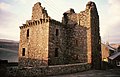 Denmylne Castle - geograph.org.uk - 4376717.jpg 1,600 × 1,027; 221 KB
-
 Devalued water - geograph.org.uk - 4131245.jpg 2,048 × 1,536; 1.55 MB
-
 Disused Quarries, Lindores Hill - geograph.org.uk - 6341394.jpg 640 × 427; 72 KB
-
 Easter eggs - geograph.org.uk - 2383845.jpg 1,024 × 736; 274 KB
-

-

-
 En Route To Cowden Hill - geograph.org.uk - 4600653.jpg 2,560 × 1,920; 2.24 MB
-
 Entering Grange of Lindores from the south - geograph.org.uk - 3987718.jpg 4,608 × 3,456; 3.14 MB
-
 Farm track and peas - geograph.org.uk - 4096178.jpg 640 × 360; 233 KB
-
 Farmland at Black Earnside - geograph.org.uk - 3896145.jpg 640 × 480; 54 KB
-
 Farmland near Easter Lumbennie - geograph.org.uk - 3048256.jpg 640 × 457; 273 KB
-
 Farmland near Grange of Lindores - geograph.org.uk - 3048119.jpg 640 × 480; 330 KB
-
 Farmland, Parkhill - geograph.org.uk - 3844786.jpg 640 × 360; 189 KB
-
 Field boundaries at Ormiston - geograph.org.uk - 3048121.jpg 640 × 480; 286 KB
-
 Fields above the Tay - geograph.org.uk - 5576551.jpg 1,024 × 670; 194 KB
-
 Fields beside the River Tay - geograph.org.uk - 5832616.jpg 2,592 × 1,944; 1.36 MB
-
 Fife Coast Path on Silver Hill - geograph.org.uk - 6341393.jpg 427 × 640; 115 KB
-
 Fishing Boats and Lindores loch - geograph.org.uk - 4412672.jpg 1,066 × 800; 168 KB
-
 Fishing boats, Loch of Lindores - geograph.org.uk - 4915301.jpg 1,024 × 683; 359 KB
-
 Fishing on Golden Loch - geograph.org.uk - 3987510.jpg 2,187 × 1,575; 984 KB
-
 Fishing on Golden Loch - geograph.org.uk - 4412694.jpg 1,066 × 800; 215 KB
-
 Floodwater, Woodmill - geograph.org.uk - 2548357.jpg 640 × 480; 356 KB
-
 Gate on Collessie to Lindores Loch path - geograph.org.uk - 4929460.jpg 1,600 × 1,600; 1.52 MB
-
 Gate Posts and Entrance to Lindores House - geograph.org.uk - 4412679.jpg 1,066 × 800; 379 KB
-
 Golden Hill telecoms mast - geograph.org.uk - 4131384.jpg 1,536 × 2,048; 427 KB
-
 Golden Loch - geograph.org.uk - 5869847.jpg 5,184 × 3,888; 5.18 MB
-
 Golden Loch fishery - geograph.org.uk - 2058853.jpg 640 × 480; 100 KB
-
 Golden Loch fishery - geograph.org.uk - 2059710.jpg 640 × 480; 59 KB
-
 Goldenloch, by Lindores, Fife - geograph.org.uk - 5482361.jpg 1,024 × 584; 232 KB
-
 Grange Farm - geograph.org.uk - 4412689.jpg 1,066 × 800; 176 KB
-
 Grange of Lindores - geograph.org.uk - 2383971.jpg 2,560 × 1,920; 1.2 MB
-
 Harvested cereal fields beside the River Tay - geograph.org.uk - 5918985.jpg 1,600 × 1,067; 166 KB
-
 Harvesting at Grange of Lindores - geograph.org.uk - 2058842.jpg 640 × 480; 80 KB
-
 Heading for Newburgh in Fife - geograph.org.uk - 1896004.jpg 640 × 480; 75 KB
-
 Horse at Parkhill - geograph.org.uk - 5576533.jpg 1,024 × 682; 191 KB
-
 Horses at Lindores - geograph.org.uk - 5869843.jpg 5,184 × 3,888; 4.02 MB
-
 Houses at Berryhill - geograph.org.uk - 2058856.jpg 640 × 480; 97 KB
-
 Inchrye gatehouse - geograph.org.uk - 3663681.jpg 2,048 × 1,536; 1.14 MB
-
 Inchrye Gatehouse - geograph.org.uk - 4412674.jpg 1,066 × 800; 299 KB
-
 Kirk of Abdie and Dunbog - geograph.org.uk - 3987728.jpg 4,608 × 3,456; 3.31 MB
-
 Kirk of Abdie and Dunbog - geograph.org.uk - 4412685.jpg 1,066 × 800; 246 KB
-
 Lindores Loch - geograph.org.uk - 2372916.jpg 640 × 476; 72 KB
-
 Lindores Loch - geograph.org.uk - 2372927.jpg 640 × 453; 62 KB
-
 Lindores Loch - geograph.org.uk - 4915297.jpg 1,024 × 683; 151 KB
-
 Lodge gates to Pitcairlie estate - geograph.org.uk - 3986930.jpg 1,835 × 1,507; 941 KB
-

-
 Mugdrum Island - geograph.org.uk - 5832625.jpg 2,592 × 1,944; 926 KB
-
 Narrow Minor Road - geograph.org.uk - 4600682.jpg 2,560 × 1,920; 1.98 MB
-
 North side of Lindores Hill - geograph.org.uk - 4095427.jpg 640 × 480; 323 KB
-

-
 Old Parkhill, near Newburgh - geograph.org.uk - 6341405.jpg 640 × 427; 106 KB
-
 On Woodmill Hill - geograph.org.uk - 3282245.jpg 640 × 480; 127 KB
-
 Open gate - geograph.org.uk - 2383893.jpg 2,560 × 1,920; 1.07 MB
-
 Ormiston Hill (Black Cairn Hill) - geograph.org.uk - 4095988.jpg 2,560 × 1,920; 2.33 MB
-
 Parkhill Mill - geograph.org.uk - 6404949.jpg 1,600 × 1,077; 497 KB
-

-
 Path on Ormiston Hill in winter - geograph.org.uk - 6341419.jpg 640 × 427; 88 KB
-
 Path through woodland at Lindores - geograph.org.uk - 6341432.jpg 427 × 640; 115 KB
-
 Pea crop, Black Earnside - geograph.org.uk - 4096953.jpg 640 × 360; 242 KB
-
 Pier at Lindores Loch - geograph.org.uk - 6097487.jpg 640 × 427; 50 KB
-
 Pier, Lindores Loch - geograph.org.uk - 4915290.jpg 1,024 × 683; 332 KB
-
 Piers, Lindores Loch - geograph.org.uk - 4915293.jpg 1,024 × 683; 293 KB
-
 Pitcairlie Burn - geograph.org.uk - 3567659.jpg 640 × 480; 373 KB
-
 Railway Bridge near Cairneyhall Farm - geograph.org.uk - 5206092.jpg 1,600 × 1,600; 1.69 MB
-
 Railway bridge, Den of Lindores - geograph.org.uk - 2548410.jpg 640 × 480; 338 KB
-
 Railway Line near Woodmill Mains - geograph.org.uk - 4412668.jpg 1,066 × 800; 310 KB
-
 Remains of a wall - geograph.org.uk - 4131368.jpg 2,048 × 1,536; 1.54 MB
-
 Remains of Denmylne Castle - geograph.org.uk - 3987770.jpg 4,608 × 3,456; 3.47 MB
-
 Ripening barley - geograph.org.uk - 4129057.jpg 2,048 × 1,536; 1.5 MB
-
 River Tay at Little Bank - geograph.org.uk - 3352309.jpg 640 × 457; 327 KB
-
 Road Bridge over Railway Line - geograph.org.uk - 4412682.jpg 1,066 × 800; 391 KB
-
 Road into Kinnaird - geograph.org.uk - 4132898.jpg 1,897 × 1,377; 846 KB
-
 Road to Newburgh - geograph.org.uk - 3844791.jpg 640 × 360; 210 KB
-
 Road, Black Earnside - geograph.org.uk - 3844806.jpg 640 × 360; 195 KB
-
 Roadside ruins near Kinnaird in Fife - geograph.org.uk - 1896018.jpg 640 × 480; 69 KB
-
 Round bales near Halton Hill - geograph.org.uk - 3844724.jpg 640 × 480; 284 KB
-
 Ruined structure at side of A913 - geograph.org.uk - 5091933.jpg 640 × 480; 45 KB
-

-

-
 Single track railway - geograph.org.uk - 3658258.jpg 2,048 × 1,536; 936 KB
-
 Small pond on Baw Hill - geograph.org.uk - 5747576.jpg 1,600 × 1,067; 303 KB
-
 South end of Golden Loch - geograph.org.uk - 3987514.jpg 4,608 × 3,456; 3.15 MB
-
 Steep fields on the bank of the Firth of Tay - geograph.org.uk - 5576548.jpg 1,024 × 630; 159 KB
-
 Strange enclosure near Woodmill Mains - geograph.org.uk - 5206103.jpg 1,600 × 1,600; 2.1 MB
-
 Straw bales at Grange of Lindores - geograph.org.uk - 2058822.jpg 640 × 480; 73 KB
-
 Stubble field - geograph.org.uk - 3663686.jpg 2,048 × 1,536; 1.04 MB
-
 Stubble field at Grange of Lindores - geograph.org.uk - 2058832.jpg 640 × 480; 83 KB
-
 Stubble, Cairneyhall - geograph.org.uk - 4915261.jpg 1,024 × 683; 465 KB
-
 Summit of Cowden Hill - geograph.org.uk - 2548376.jpg 640 × 480; 263 KB
-
 Summit of Cowden Hill - geograph.org.uk - 2548382.jpg 640 × 480; 297 KB
-
 Telecoms mast - geograph.org.uk - 2383967.jpg 1,781 × 2,336; 439 KB
-

-

-
 The brae south of Braeside Mains - geograph.org.uk - 4132894.jpg 2,048 × 1,536; 1.57 MB
-
 The top of a motte - geograph.org.uk - 3663692.jpg 2,048 × 1,536; 1.21 MB
-
 Track and Footpath to Braeside and Collessie - geograph.org.uk - 4412663.jpg 1,066 × 800; 381 KB
-
 Track near Black Hill - geograph.org.uk - 3049460.jpg 640 × 480; 366 KB
-
 Track to Black Hill - geograph.org.uk - 2383885.jpg 2,560 × 1,920; 1.13 MB
-
 Tracks in barley field - geograph.org.uk - 5869840.jpg 5,184 × 3,888; 6.45 MB
-
 Tree in a field - geograph.org.uk - 5869832.jpg 5,184 × 3,888; 5.11 MB
-
 Trees and gorse - geograph.org.uk - 3987539.jpg 4,608 × 3,456; 3.56 MB
-
 Uncultivated land on Cairnie Hill - geograph.org.uk - 3779110.jpg 1,500 × 905; 1.53 MB
-
 Under the power lines - geograph.org.uk - 4131362.jpg 2,048 × 1,536; 1.57 MB
-
 Undulating furrows - geograph.org.uk - 2383857.jpg 2,560 × 1,920; 786 KB
-
 Unusual bell tower - geograph.org.uk - 2383979.jpg 2,560 × 1,920; 1.34 MB
-

-

-
 View over the Tay - geograph.org.uk - 4096183.jpg 640 × 360; 226 KB
-
 View to Dunbog Hill and windmills - geograph.org.uk - 5352819.jpg 1,600 × 1,067; 1,023 KB
-
 View towards Black Hill - geograph.org.uk - 3048241.jpg 640 × 480; 386 KB
-
 View towards Halton Hill - geograph.org.uk - 4131374.jpg 2,048 × 1,536; 1.58 MB
-
 View upstream River Tay - geograph.org.uk - 4615308.jpg 4,608 × 3,456; 3.11 MB
-
 Warwickshire exile^ - geograph.org.uk - 3844775.jpg 640 × 381; 213 KB
-
 Well at Berryhill - geograph.org.uk - 2059700.jpg 640 × 480; 123 KB
-
 Wetland, Lindores - geograph.org.uk - 4141597.jpg 800 × 600; 413 KB
-
 Winter on Silver Hill - geograph.org.uk - 6341392.jpg 640 × 427; 85 KB
-
 Woodhead Farm - geograph.org.uk - 2059714.jpg 640 × 480; 101 KB
-
 Woodhead Farm - geograph.org.uk - 4412699.jpg 1,066 × 800; 222 KB
-
 Woodhead Farm cottage - geograph.org.uk - 3987524.jpg 2,131 × 1,383; 968 KB
-
 Woodmill Farm - geograph.org.uk - 4412703.jpg 1,066 × 800; 292 KB
-
 Woodmill Hill - geograph.org.uk - 2383876.jpg 2,560 × 1,920; 871 KB
-
 Woodmill Hill - geograph.org.uk - 4210690.jpg 4,604 × 3,107; 5.83 MB
-
 Woodmill Mains - geograph.org.uk - 3663652.jpg 2,048 × 1,536; 1.57 MB
-
 Woodmill Mains - geograph.org.uk - 4412665.jpg 1,066 × 800; 245 KB
-
 Woodmill steading - geograph.org.uk - 3985675.jpg 1,551 × 1,355; 731 KB


_-_geograph.org.uk_-_4095988.jpg)


