Category:A map of the British Empire in America with the French and Spanish settlements adjacent thereto
Jump to navigation
Jump to search
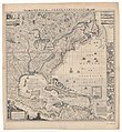
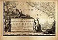
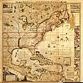
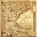
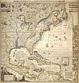
English: A map of the British Empire in America, with the French, Spanish and Hollandish settlements adjacent thereto
by Henry Popple, 1733
by Henry Popple, 1733
Latina: America septentrionalis
Media in category "A map of the British Empire in America with the French and Spanish settlements adjacent thereto"
The following 103 files are in this category, out of 103 total.
-
 1733 Havana map by Popple BPL 12807.png 645 × 729; 960 KB
-

-

-

-

-

-

-

-
-

-

-

-

-

-

-

-

-

-

-

-

-

-

-

-

-

-

-

-

-

-

-
-

-
-
-

-

-

-

-

-

-

-

-

-

-

-

-

-

-

-

-

-

-

-

-

-

-

-

-

-

-

-

-

-

-

-

-

-

-

-

-

-

-

-

-

-

-

-

-

-

-

-

-

-

-

-

-

-

-

-

-

-

-

-
 A map of the British Empire in America.jpg 4,235 × 4,433; 8.53 MB
-

-

-
 ApalacheeRegion1733.jpg 1,000 × 800; 150 KB
-
 CarolinaToFloridaCoast1733.jpg 964 × 972; 483 KB
-

-
 Compassrose.png 485 × 753; 176 KB
-
 New York and Perthamboy Harbours. NYPL434637.tiff 4,746 × 5,580; 75.79 MB
-
 Plans des isles, rades, et ports de plusieurs lieux de lAmérique (4071881651).jpg 2,000 × 1,434; 2.83 MB

.jpg)
.jpg)
.jpg)
.jpg)
.jpg)
.jpg)
.jpg)


.jpg)
.jpg)
.jpg)
.jpg)
.jpg)
.jpg)
.jpg)
.jpg)
.jpg)
.jpg)
.jpg)
.jpg)
.jpg)
.jpg)
.jpg)
.jpg)
.jpg)
.jpg)
.jpg)
.jpg)
.jpg)
.jpg)
.jpg)
.jpg)
.jpg)


.jpg)