Category:49 - 56 Fieldway
Jump to navigation
Jump to search
| Object location | | View all coordinates using: OpenStreetMap |
|---|
building in Liverpool, Merseyside, England, UK  | |||||
| Upload media | |||||
| Instance of | |||||
|---|---|---|---|---|---|
| Location | Liverpool, Merseyside, North West England, England | ||||
| Heritage designation |
| ||||
 | |||||
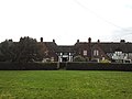
Range of eight Grade II listed houses, c. 1914 in Fieldsway, Wavertree Garden Suburb, Liverpool.
Media in category "49 - 56 Fieldway"
The following 5 files are in this category, out of 5 total.
-
 49 - 56 Fieldway 1.jpg 4,940 × 3,361; 6.7 MB
-
 49 - 56 Fieldway 2.jpg 4,850 × 3,503; 8.2 MB
-
 49 - 56 Fieldway 3.jpg 4,869 × 3,677; 9.96 MB
-
 49 - 56 Fieldway 4.jpg 4,804 × 3,665; 7.73 MB
-
 49 - 56 Fieldway 5.jpg 5,152 × 3,864; 8.42 MB


