Category:2016 Iowa election maps
Jump to navigation
Jump to search
States of the United States: Arizona · California · Colorado · Illinois · Iowa · Kentucky · Michigan · New York · North Carolina · Ohio · Pennsylvania · South Carolina
Media in category "2016 Iowa election maps"
The following 12 files are in this category, out of 12 total.
-
 2016 IA-1.svg 800 × 646; 77 KB
-
 2016 IA-2.svg 800 × 466; 95 KB
-
 2016 IA-3.svg 800 × 512; 51 KB
-
 2016 IA-4.svg 800 × 485; 132 KB
-
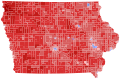
 2016 Iowa republican caucuses - county map.png 2,048 × 1,258; 187 KB
-
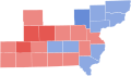
 2016 Iowa State Senate Election.svg 670 × 400; 246 KB
-

-
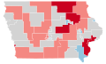
 Democrats Party presidential primaries in Iowa, 2016.png 4,000 × 2,689; 444 KB
-
 IA President 2016.svg 810 × 532; 5.99 MB
-
 IA Senate 2016.svg 810 × 532; 5.99 MB
-
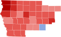
 Iowa County Flips 2016.svg 744 × 498; 179 KB
-
 Iowa Democratic Senate primary, 2016.svg 302 × 203; 39 KB


