Category:2010s maps of Palestine
Jump to navigation
Jump to search
Media in category "2010s maps of Palestine"
The following 4 files are in this category, out of 4 total.
-
 Map of Gaza Strip with no-go zone 2012.jpg 4,732 × 5,712; 4.93 MB
-
 Gaza closure December 2012.jpg 4,732 × 5,712; 3.53 MB
-
 Gaza Strip Rafah Access and closure Jul 2018.png 1,683 × 2,381; 1.6 MB
-
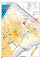 North Gaza July 2018.png 1,683 × 2,381; 1.56 MB


