Category:19th-century maps of Caernarfonshire
Jump to navigation
Jump to search

Media in category "19th-century maps of Caernarfonshire"
The following 8 files are in this category, out of 8 total.
-
 Ordnance Survey Drawings - Ffestiniog (OSD 305).jpg 5,702 × 2,961; 2.73 MB
-
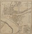 Caernarvon town plan 4669576.jpg 2,151 × 2,315; 2.85 MB
-
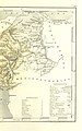
 LEWIS(1833) p1.199 CARNARVONSHIRE.jpg 2,885 × 2,361; 3.01 MB
-
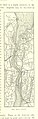
 102 of 'England and Wales Delineated, etc' (11034650334).jpg 1,519 × 2,431; 803 KB
-
 103 of 'England and Wales Delineated, etc' (11033082715).jpg 1,519 × 2,431; 807 KB
-
-
 Admiralty Chart No 368 Wales Barmouth to South Stack, Published 1896.jpg 9,517 × 12,093; 16.97 MB
-
 Admiralty Chart No 1411 New Quay to Holyhead, Published 1878.jpg 10,856 × 16,162; 16.17 MB
.jpg)

_p1.199_CARNARVONSHIRE.jpg)
.jpg)
.jpg)


%27_(11297279946).jpg)