Category:1973 maps
Jump to navigation
Jump to search
| ← · 1970 · 1971 · 1972 · 1973 · 1974 · 1975 · 1976 · 1977 · 1978 · 1979 · → |
Deutsch: Karten mit Bezug zum Jahr 1973
English: Maps related to the year 1973
Español: Mapas relativos al año 1973
Français : Cartes concernant l’an 1973
Русский: Карты 1973 года
Subcategories
This category has the following 7 subcategories, out of 7 total.
Media in category "1973 maps"
The following 69 files are in this category, out of 69 total.
-
 Acadia National Park. LOC 75692041.jpg 3,857 × 5,027; 4.01 MB
-
 Acadia National Park. LOC 75692041.tif 3,857 × 5,027; 55.47 MB
-
 AZ alitalia 1973 2 intercontinental network.jpg 1,075 × 1,200; 284 KB
-
 Cape Cod National Seashore. May 1968. LOC 75692098.jpg 5,830 × 5,117; 4.23 MB
-
 Cape Cod National Seashore. May 1968. LOC 75692098.tif 5,830 × 5,117; 85.35 MB
-
 Catoctin Mountain Park. LOC 75692092.jpg 7,940 × 3,425; 4.76 MB
-
 Catoctin Mountain Park. LOC 75692092.tif 7,940 × 3,425; 77.8 MB
-
 Chickamauga Battlefield LOC 78695396.jpg 3,225 × 5,615; 3.19 MB
-
 Chickamauga Battlefield LOC 78695396.tif 3,225 × 5,615; 51.81 MB
-
 Dahomey-Niger boundary. LOC 84692244.tif 3,133 × 4,150; 37.2 MB
-

-

-
 Fiberwood use in Washington, Oregon, and California, 1970-80 (1973) (19953260223).jpg 1,774 × 2,057; 857 KB
-
 Fort Davis. LOC 73695972.jpg 6,098 × 5,736; 4.85 MB
-
 Fort Davis. LOC 73695972.tif 6,098 × 5,736; 100.07 MB
-
 Fort Raleigh National Historic Site. LOC 73695971.jpg 5,995 × 3,470; 2.91 MB
-
 Fort Raleigh National Historic Site. LOC 73695971.tif 5,995 × 3,470; 59.52 MB
-
 France location map-Departements 1973-1974.svg 2,000 × 1,922; 673 KB
-
 George Washington National Forest, Pedlar Ranger District. LOC 75695968.jpg 9,830 × 9,319; 11.43 MB
-
 George Washington National Forest, Pedlar Ranger District. LOC 75695968.tif 9,830 × 9,319; 262.09 MB
-
 Gettysburg National Military Park, Pennsylvania. LOC 75692091.jpg 7,256 × 3,904; 4.63 MB
-
 Gettysburg National Military Park, Pennsylvania. LOC 75692091.tif 7,256 × 3,904; 81.05 MB
-
 Great Falls Park, Virginia. LOC 73695987.jpg 10,645 × 4,639; 6.68 MB
-
 Great Falls Park, Virginia. LOC 73695987.tif 10,645 × 4,639; 141.28 MB
-
 Great Smoky Mountains National Park. 1971. LOC 73696496.jpg 5,962 × 3,452; 3.46 MB
-
 Great Smoky Mountains National Park. 1971. LOC 73696496.tif 5,962 × 3,452; 58.88 MB
-
 Guadalupe Mountains National Park. 1972. LOC 73695960.jpg 5,027 × 7,032; 5.39 MB
-
 Guadalupe Mountains National Park. 1972. LOC 73695960.tif 5,027 × 7,032; 101.14 MB
-
 Jefferson County, Pennsylvania LOC 82696137.jpg 5,261 × 6,740; 4.84 MB
-
 Jefferson County, Pennsylvania LOC 82696137.tif 5,261 × 6,740; 101.45 MB
-
 John H. Kerr Reservoir, Virginia and North Carolina LOC 80693296.jpg 8,978 × 6,937; 6.83 MB
-
 John H. Kerr Reservoir, Virginia and North Carolina LOC 80693296.tif 8,978 × 6,937; 178.19 MB
-
 Kerr Reservoir, Virginia and North Carolina LOC 2013587300.jpg 8,821 × 6,902; 7 MB
-
 Kerr Reservoir, Virginia and North Carolina LOC 2013587300.tif 8,821 × 6,902; 174.19 MB
-
 Lake Chad 1973.jpg 971 × 997; 553 KB
-
 Lake Seminole. LOC 76691425.jpg 7,033 × 10,289; 12 MB
-
 Lake Seminole. LOC 76691425.tif 7,033 × 10,289; 207.03 MB
-
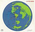 Lan Chile 1973.jpg 1,075 × 969; 251 KB
-
 Linville Gorge Wilderness. LOC 74691144.tif 12,574 × 8,885; 319.63 MB
-
 Map of Eurovision 1973.gif 1,236 × 1,245; 36 KB
-
 Maryland and Delaware, base map with highways and contours LOC 83694148.jpg 10,632 × 6,780; 7.65 MB
-
 Maryland and Delaware, base map with highways and contours LOC 83694148.tif 10,632 × 6,780; 206.24 MB
-
 Morocco ethno 1973 all v2.svg 800 × 630; 64 KB
-
 Nation's capital area. (Washington D.C. and Cheaspeake Bay regions) LOC 74691244.jpg 9,330 × 9,531; 16.69 MB
-
 Nation's capital area. (Washington D.C. and Cheaspeake Bay regions) LOC 74691244.tif 9,330 × 9,531; 254.41 MB
-
 Nation's capital area. (Washington D.C. and Chesapeake Bay regions) LOC 73696352.jpg 12,164 × 9,463; 18.52 MB
-
 Nation's capital area. (Washington D.C. and Chesapeake Bay regions) LOC 73696352.tif 12,164 × 9,463; 329.33 MB
-
 National forest wildernesses and primitive areas, January 1973 LOC 79692720.jpg 7,250 × 6,187; 6.52 MB
-
 National forest wildernesses and primitive areas, January 1973 LOC 79692720.tif 7,250 × 6,187; 128.33 MB
-
 Orange County, Virginia LOC 82693335.jpg 10,416 × 6,494; 3.94 MB
-
 Orange County, Virginia LOC 82693335.tif 10,416 × 6,494; 193.52 MB
-
 Padre Island National Seashore. LOC 78690534.jpg 6,059 × 5,163; 4.44 MB
-
 Padre Island National Seashore. LOC 78690534.tif 6,059 × 5,163; 89.5 MB
-
 Pike County, Pennsylvania LOC 82696136.jpg 5,828 × 7,270; 5.83 MB
-
 Pike County, Pennsylvania LOC 82696136.tif 5,828 × 7,270; 121.22 MB
-
 Pisgah National Forest (French Board Ranger District), North Carolina. LOC 75695946.jpg 6,542 × 6,491; 8.25 MB
-
 Pisgah National Forest (French Board Ranger District), North Carolina. LOC 75695946.tif 6,542 × 6,491; 121.49 MB
-
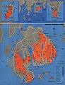
 Population Map of South Korea.jpg 911 × 1,157; 375 KB
-
 Shenandoah National Park. LOC 73696498.jpg 11,125 × 6,585; 8.99 MB
-
 Shenandoah National Park. LOC 73696498.tif 11,125 × 6,585; 209.59 MB
-
 Shining Rock Wilderness. LOC 75690144.jpg 12,363 × 6,840; 14.99 MB
-
 South Vietnam population and administrative divisions, September 1972. 3-73. LOC 75690894.tif 6,149 × 8,622; 151.68 MB
-
 Route of the 1973 Tour de France.png 3,198 × 3,462; 2.82 MB
-
 Upper Chesapeake Bay. LOC 74691927.jpg 7,392 × 6,084; 6.98 MB
-
 Upper Chesapeake Bay. LOC 74691927.tif 7,392 × 6,084; 128.67 MB
-
 Vicksburg National Military Park. LOC 73695985.jpg 3,996 × 5,661; 3.41 MB
-
 Vicksburg National Military Park. LOC 73695985.tif 3,996 × 5,661; 64.72 MB
-
 Water resources investigations in New Jersey, 1972. LOC 76692478.jpg 9,505 × 6,210; 7.87 MB
-
 Water resources investigations in New Jersey, 1972. LOC 76692478.tif 9,505 × 6,210; 168.88 MB


_(19953260223).jpg)


_LOC_74691244.jpg)
_LOC_73696352.jpg)


,_North_Carolina._LOC_75695946.jpg)


