Category:1960s maps of Japan
Jump to navigation
Jump to search
Subcategories
This category has the following 3 subcategories, out of 3 total.
- 1967 maps of Japan (4 F)
Media in category "1960s maps of Japan"
The following 19 files are in this category, out of 19 total.
-

-
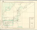 Admiralty Chart Catalogue 1967 Page 072 Index L.jpg 8,567 × 6,852; 8.14 MB
-
 Admiralty Chart Catalogue 1967 Page 075 Index L1.jpg 8,596 × 6,823; 9.45 MB
-
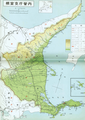
 Hokkaido Abashiri subpref 1966 map.webp 12,587 × 8,848; 9.09 MB
-
 Hokkaido Hidaka subpref 1966 map.webp 4,137 × 2,846; 2.26 MB
-
 Hokkaido Hiyama subpref 1966 map.webp 2,864 × 4,068; 2.12 MB
-
 Hokkaido Iburi 1966 map.webp 4,035 × 2,859; 2.05 MB
-
 Hokkaido Kushiro 1966 map.webp 4,018 × 2,846; 2.43 MB
-
 Hokkaido Nemuro 1966 map.webp 8,746 × 12,304; 7.18 MB
-
 Hokkaido North 1966 map.webp 3,967 × 2,804; 1.71 MB
-
 Hokkaido Oshima subpref 1966 map.webp 2,849 × 4,054; 2.05 MB
-
 Hokkaido Rumoi subpref 1966 map.webp 2,831 × 4,014; 1.91 MB
-
 Hokkaido Rumoi subpref 1966 North map.webp 2,768 × 2,476; 2.36 MB
-
 Hokkaido Rumoi subpref 1966 South map.webp 2,448 × 2,003; 2.03 MB
-
 Hokkaido Shiribeshi 1966 map.webp 12,698 × 8,772; 9.24 MB
-
 Hokkaido Sorachi subpref 1966 South map.webp 2,844 × 1,838; 1.54 MB
-
 Hokkaido Souya subpref 1966 map.webp 2,747 × 4,020; 2.03 MB
-
 Hokkaido Tokachi subpref 1966 map.webp 2,846 × 4,002; 2.64 MB
-
 Japan Postal Network 1964.webp 8,962 × 5,171; 6.38 MB
.jpg)


