Category:1960 U.S. presidential election maps, county subdivisions
Jump to navigation
Jump to search
Media in category "1960 U.S. presidential election maps, county subdivisions"
The following 10 files are in this category, out of 10 total.
-
 PresidentialCounty1960Colorbrewer.gif 2,800 × 1,700; 235 KB
-
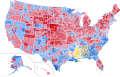 1960 United States presidential election results map by county.svg 555 × 352; 1.44 MB
-
 1960prescountymap.PNG 1,513 × 983; 175 KB
-
 1960prescountymap2.PNG 1,513 × 983; 200 KB
-
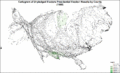
 CartogramDemocraticPresidentialCounty1960Colorbrewer.gif 2,800 × 1,700; 213 KB
-
 CartogramOtherPresidentialCounty1960Colorbrewer.gif 2,800 × 1,700; 187 KB
-
 CartogramPresidentialCounty1960Colorbrewer.gif 2,800 × 1,700; 233 KB
-
 CartogramRepublicanPresidentialCounty1960Colorbrewer.gif 2,800 × 1,700; 214 KB
-
 CartogramUnpledgedElectorsPresidentialCounty1960Colorbrewer.gif 2,800 × 1,700; 168 KB
-
 PresidentialCounty1960.png 1,513 × 983; 197 KB


