Category:1931 maps
Jump to navigation
Jump to search
| ← · 1930 · 1931 · 1932 · 1933 · 1934 · 1935 · 1936 · 1937 · 1938 · 1939 · → |
Deutsch: Karten mit Bezug zum Jahr 1931
English: Maps related to the year 1931
Español: Mapas relativos al año 1931
Français : Cartes concernant l’an 1931
Русский: Карты 1931 года
Subcategories
This category has the following 9 subcategories, out of 9 total.
Media in category "1931 maps"
The following 92 files are in this category, out of 92 total.
-

-

-
 A map of Chicago's gangland from authentic sources (NBY 1428).jpg 3,600 × 2,914; 3.05 MB
-
 Carte de l'itineraire et de l'etat des Glaces (FL173354405 3150564).jpg 9,135 × 7,891; 73.31 MB
-
 Environs de Jérusalem (FL169299494 0983178).jpg 7,127 × 7,371; 58.17 MB
-
 French Service géographique de l'armée, Environs d'Homs (FL154453004 4083899).jpg 13,108 × 17,760; 235.44 MB
-
 French Service géographique de l'armée, Environs de Hama (FL147439334 4083829).jpg 12,903 × 17,036; 278.26 MB
-
 French Service géographique de l'armée, Hama ouest (FL147448691 4083902).jpg 13,011 × 17,302; 246.94 MB
-

-

-
 Ghent, Belgium ; 1931 La Propagande Internationale.jpg 1,600 × 1,430; 631 KB
-

-

-
 Hugo Herrmann, Bird's eye view of Palestine 01-map (FL33253930 3431402).jpg 11,869 × 9,354; 174.89 MB
-
 Hugo Herrmann, Bird's eye view of Palestine 02-verso-text (FL33253931 3431402).jpg 11,808 × 9,226; 168.31 MB
-
 Jewish National Fund, Erets Israel (FL197694326 1100165).jpg 11,965 × 16,642; 252.96 MB
-
 Jewish National Fund, Karte von Erez Israel (FL197694341 1108520).jpg 11,896 × 16,663; 263.59 MB
-
 Jewish National Fund, Map of Erez Israel (FL25553363 2366922).jpg 12,157 × 16,806; 285.31 MB
-
 Keren HaYesod, מפת ארץ ישראל ממעוף הצפור 01-map (FL44248413 2367693).jpg 12,067 × 9,365; 158.9 MB
-
 Keren HaYesod, מפת ארץ ישראל ממעוף הצפור 02-verso (FL44248416 2367693).jpg 12,185 × 9,476; 151.15 MB
-
 Lemuria map.jpg 367 × 279; 46 KB
-
 Lemuria mumap2.jpg 360 × 272; 37 KB
-

-
 Mapa de la República de Colombia, 1931.jpg 5,086 × 6,121; 4.5 MB
-
 MosTramLines-31.gif 2,088 × 2,374; 190 KB
-

-
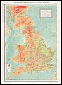 Ordnance Survey, Map of Roman Britain 00-map (FL37660708 2582616).jpg 15,610 × 21,345; 484.49 MB
-
 Ordnance Survey, Map of Roman Britain 01-idnex-cover (FL37660710 2582616).jpg 2,744 × 3,742; 11.53 MB
-
 Ordnance Survey, Map of Roman Britain 02-index-p (FL37660718 2582616).jpg 4,397 × 3,744; 13.66 MB
-
 Ordnance Survey, Map of Roman Britain 03-index-9 (FL37660725 2582616).jpg 4,683 × 3,744; 12.98 MB
-
 Ordnance Survey, Map of Roman Britain 04-index-p (FL37660734 2582616).jpg 4,659 × 3,715; 14.65 MB
-
 Ordnance Survey, Map of Roman Britain 05-index-p (FL37660741 2582616).jpg 4,725 × 3,733; 13.72 MB
-
 Ordnance Survey, Map of Roman Britain 06-index-p (FL37660746 2582616).jpg 4,731 × 3,744; 12.98 MB
-
 Ordnance Survey, Map of Roman Britain 07-index-p (FL37660751 2582616).jpg 4,665 × 3,733; 13.78 MB
-
 Ordnance Survey, Map of Roman Britain 08-index-p (FL37660754 2582616).jpg 4,713 × 3,721; 14.03 MB
-
 Ordnance Survey, Map of Roman Britain 09-index-p (FL37660760 2582616).jpg 4,671 × 3,727; 13.86 MB
-
 Ordnance Survey, Map of Roman Britain 10-index-p (FL37660766 2582616).jpg 2,502 × 3,688; 6.83 MB
-
 Bahnstrecke Zeitz-Camburg 1930.png 20,400 × 6,432; 19.58 MB
-
 Bahnstrecke Zeitz-Camburg 1930C2.png 20,400 × 6,432; 13.91 MB
-
-
 Plán Hanoie.jpg 1,070 × 1,163; 522 KB
-
 Plán Hanoie2.jpg 731 × 624; 264 KB
-
 Republika po Anschlussu.jpg 1,117 × 703; 182 KB
-
 Road map, Washington and vicinity, Maryland-Virginia-District of Columbia LOC 87695636.jpg 9,946 × 6,041; 9.56 MB
-
 Road map, Washington and vicinity, Maryland-Virginia-District of Columbia LOC 87695636.tif 9,946 × 6,041; 171.9 MB
-
 Situation at Harper's Ferry, Sep't 15 - 1862, 7A.M. LOC 2005625358.jpg 3,031 × 2,190; 761 KB
-
 Situation at Harper's Ferry, Sep't 15 - 1862, 7A.M. LOC 2005625358.tif 3,031 × 2,190; 18.99 MB
-
 Soil Map, Kiowa County, Oklahoma LOC 2010587906.jpg 13,583 × 11,735; 16.63 MB
-
 Survey of Palestine, Er Ramle (FL7330214 2369506).jpg 3,870 × 5,054; 25.83 MB
-
 Survey of Palestine, Er Ramle (FL7330223 2369506).jpg 9,152 × 10,424; 110.18 MB
-
 Survey of Palestine, Er Ramle (FL7330228 2369506).jpg 8,978 × 9,293; 111.29 MB
-
 Survey of Palestine, Er Ramle (FL7330235 2369506).jpg 10,301 × 9,230; 115.87 MB
-
 Survey of Palestine, Er Ramle (FL7330239 2369506).jpg 9,000 × 9,288; 110.91 MB
-
 Survey of Palestine, Er Ramle (FL7330243 2369506).jpg 10,328 × 9,288; 123.03 MB
-
 Survey of Palestine, Gaza (FL27925337 2366965).jpg 14,009 × 20,182; 372.98 MB
-
 Survey of Palestine, Hebron 00-index (FL10423193 2369504).jpg 4,201 × 4,204; 22.72 MB
-
 Survey of Palestine, Hebron 01 (FL10423196 2369504).jpg 6,779 × 7,168; 57.39 MB
-
 Survey of Palestine, Hebron 02 (FL10423200 2369504).jpg 6,821 × 7,208; 59.65 MB
-
 Survey of Palestine, Hebron 03 (FL10423202 2369504).jpg 6,812 × 7,198; 60.48 MB
-
 Survey of Palestine, Hebron 04 (FL10423206 2369504).jpg 6,811 × 7,172; 56.09 MB
-
 Survey of Palestine, Hebron 05 (FL10423208 2369504).jpg 6,884 × 7,534; 61.9 MB
-
 Survey of Palestine, Hebron 06 (FL10423212 2369504).jpg 6,795 × 7,078; 63.88 MB
-
 Survey of Palestine, Hebron 07 (FL10423215 2369504).jpg 6,786 × 7,201; 58.21 MB
-
 Survey of Palestine, Hebron 08 (FL10423216 2369504).jpg 6,907 × 7,952; 58.21 MB
-
 Survey of Palestine, Hebron 09 (FL10423219 2369504).jpg 6,639 × 7,866; 72.29 MB
-
 Survey of Palestine, Hebron 10 (FL10423223 2369504).jpg 6,802 × 7,185; 58.35 MB
-
 Survey of Palestine, Lydda 00-index (FL42760737 2369505).jpg 9,336 × 7,132; 82.67 MB
-
 Survey of Palestine, Lydda 01 (FL42760739 2369505).jpg 13,574 × 13,497; 226.35 MB
-
 Survey of Palestine, Lydda 02 (FL42760741 2369505).jpg 13,770 × 17,511; 313.92 MB
-
 Survey of Palestine, Lydda 03 (FL42760743 2369505).jpg 13,281 × 13,619; 236.51 MB
-
 Survey of Palestine, Lydda 04 (FL42760745 2369505).jpg 13,558 × 13,721; 225.17 MB
-
 Survey of Palestine, Lydda 05 (FL42760747 2369505).jpg 14,309 × 13,824; 242.66 MB
-
 Survey of Palestine, Lydda 06 (FL42760749 2369505).jpg 13,611 × 13,647; 218.55 MB
-
 Survey of Palestine, Lydda 07 (FL42760751 2369505).jpg 16,461 × 13,975; 266.57 MB
-
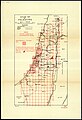
 Survey of Palestine, Sketch map of Palestine (FL27932967 2369490).jpg 8,212 × 15,963; 155.71 MB
-
 Survey of Palestine, Sketch map of Palestine (FL79973079 4166861).jpg 7,356 × 9,790; 75.82 MB
-
 Survey of Palestine, Sketch map of Palestine 01 (FL27968202 2692949).jpg 22,937 × 15,404; 399.98 MB
-
 Survey of Palestine, Sketch map of Palestine 02 (FL27968203 2692949).jpg 22,537 × 14,916; 361.12 MB
-
 Survey of Palestine, Sketch map of Palestine 03 (FL27968204 2692949).jpg 23,008 × 15,198; 375.27 MB
-
 Survey of Palestine, Sketch map of Palestine 04 (FL27968205 2692949).jpg 24,647 × 15,436; 455.09 MB
-
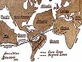
 The New World and the European colonial system, 1823 and 1931.jpg 2,354 × 2,723; 616 KB
-

-
 Topographic map of Fredericksburg and vicinity, Virginia, showing battlefields LOC 99439199.tif 4,318 × 7,243; 89.48 MB
-
 Topographic Map, Acadia National Park, Hancock County, Maine. LOC 99446118.jpg 7,855 × 6,429; 11.81 MB
-
 Topographic Map, Acadia National Park, Hancock County, Maine. LOC 99446118.tif 7,855 × 6,429; 144.48 MB
-
 White Mountain National Forest, New Hampshire and Maine, 1931. LOC 73697195.tif 7,101 × 7,811; 158.69 MB
-
 Zahna Messtischblatt df dk 0010001 4042 1931.jpg 8,420 × 8,850; 13.34 MB
-
 Балашиха-1931.png 520 × 400; 522 KB
-
 План Николаева 1931 (электрохозяйство).jpg 2,658 × 1,893; 616 KB
-
 План Николаева 1931.jpg 2,668 × 1,916; 607 KB
-
 Стрийський цвинтар.jpg 3,508 × 2,480; 3.21 MB
-
 תל אביב (FL10527677 3558256).jpg 5,230 × 7,152; 58.55 MB


.jpg)
.jpg)
.jpg)
.jpg)
.jpg)
.jpg)


.jpg)
.jpg)
.jpg)
.jpg)
.jpg)
.jpg)
.jpg)


.jpg)


.jpg)
.jpg)
.jpg)
.jpg)
.jpg)
.jpg)
.jpg)
.jpg)
.jpg)
.jpg)
.jpg)
.jpg)
.jpg)


.jpg)
.jpg)
.jpg)
.jpg)
.jpg)
.jpg)
.jpg)
.jpg)
.jpg)
.jpg)
.jpg)
.jpg)
.jpg)
.jpg)
.jpg)
.jpg)
.jpg)
.jpg)
.jpg)
.jpg)
.jpg)
.jpg)
.jpg)
.jpg)
.jpg)
.jpg)
.jpg)
.jpg)
.jpg)
.jpg)
.jpg)
.jpg)


.jpg)


.jpg)