Category:1904 maps of the United States
Jump to navigation
Jump to search
States of the United States: Idaho · Illinois · Iowa · Kansas · Louisiana · Maryland · Massachusetts · Michigan · Minnesota · Mississippi · Missouri · Montana · Nebraska · Nevada · New York · North Dakota · Ohio · Pennsylvania · South Dakota · Texas · Utah · Vermont · Washington · Wisconsin – Washington, D.C.
Subcategories
This category has the following 28 subcategories, out of 28 total.
D
I
- 1904 maps of Idaho (1 F)
- 1904 maps of Iowa (1 F)
K
L
M
- 1904 maps of Montana (6 F)
N
O
P
S
T
- 1904 maps of Texas (10 F)
U
V
W
Media in category "1904 maps of the United States"
The following 18 files are in this category, out of 18 total.
-
 Birds Eye View of Street Railway Routes in New England, 1904.png 2,392 × 3,500; 20.63 MB
-
 Bulletin (1906) (20240324620).jpg 3,064 × 1,910; 1.3 MB
-
 Chemins de fer Etats-Unis. - btv1b8444105t.jpg 10,410 × 8,016; 10.24 MB
-
 Geologic Map of the Iron Mountain area.jpg 5,312 × 2,988; 5.42 MB
-
 Geologic Map of the Menominee Range.jpg 5,312 × 2,988; 4.09 MB
-
 Map of City of Galveston.jpg 1,200 × 867; 269 KB
-
 Map of Fort Meade, South Dakota - NARA - 137930107.jpg 10,200 × 7,607; 3.76 MB
-
 Map of Fort Meade, South Dakota - NARA - 137930109.jpg 9,324 × 7,346; 3.1 MB
-

-

-

-
 North America (1904) (14596494148).jpg 1,474 × 2,344; 512 KB
-
 Orographical basin of the St Lawrence basin - by J. G. Bartholomew - btv1b530606061.jpg 9,253 × 5,464; 9.1 MB
-

-
 Plate 1 Geologic Map of Eastern Wisc.jpg 2,066 × 3,032; 1.09 MB
-
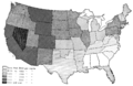 PSM V71 D388 Per capita wealth for each state and territory 1904.png 1,629 × 1,058; 414 KB
-
 The Street railway journal (1904) (14573421009).jpg 3,666 × 2,384; 1.76 MB
-
 United States (8346881776).jpg 800 × 546; 85 KB

_(20240324620).jpg)


_-_DPLA_-_15f3f93b23114a34ef930f004f565b07_(page_1).jpg)
_-_DPLA_-_6ed510c23fd6563552455bf2937da9c9_(page_1).jpg)
_-_DPLA_-_6ed510c23fd6563552455bf2937da9c9_(page_2).jpg)
_(14596494148).jpg)

_(page_4_crop).jpg)


_(14573421009).jpg)
.jpg)