Category:1903 maps of Europe
Jump to navigation
Jump to search
Temperate regions: North America · South America · Africa · Europe · Asia · Oceania – Polar regions: – Other regions:
English: 1903 maps of Europe
Español: Mapas de Europa en 1903
Suomi: Euroopan kartat vuodelta 1903
Română: Hărți ale Europei din 1903
Subcategories
This category has the following 11 subcategories, out of 11 total.
.
A
- 1903 maps of Austria (1 F)
C
- 1903 maps of Cyprus (empty)
F
- 1903 maps of France (2 F)
G
- 1903 maps of Greece (empty)
N
- 1903 maps of Norway (28 F)
R
- 1903 maps of Russia (23 F)
S
- 1903 maps of Spain (3 F)
T
- 1903 maps of Turkey (1 F)
Media in category "1903 maps of Europe"
The following 7 files are in this category, out of 7 total.
-
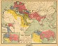
 Actual government as applied under American conditions (1903) (14784202305).jpg 2,836 × 2,136; 1.65 MB
-
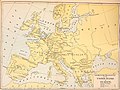
 Central Europe (1903) (14778801024).jpg 1,708 × 3,048; 1.73 MB
-

-
 Heinrich Kiepert. Orbis terrarum altero p. Chr. saeculo antiquis notus.jpg 7,104 × 5,625; 6.57 MB
-
 Kartserie 01-0204 Skansen, djurgårdsslätten 49,51 skansen, lejonslätten framnäs.png 6,354 × 5,080; 54.39 MB
-
 NIE 1905 Europe - Physical Map.jpg 3,174 × 2,598; 1,022 KB
-
 NIE 1905 Europe.jpg 3,075 × 2,580; 1.13 MB
_(14784202305).jpg)
_(14778801024).jpg)


