Category:1900s maps of the United Kingdom
Jump to navigation
Jump to search
Countries of Europe: Albania · Armenia‡ · Azerbaijan‡ · Belarus · Belgium · Bosnia and Herzegovina · Bulgaria · Croatia · Cyprus‡ · Czech Republic · Denmark · Finland · France‡ · Georgia‡ · Germany · Greece · Hungary · Iceland · Republic of Ireland · Italy · Lithuania · Netherlands‡ · Norway · Poland · Portugal‡ · Romania · Russia‡ · Serbia · Slovakia · Spain‡ · Sweden · Switzerland · Turkey‡ · Ukraine · United Kingdom
Limited recognition: Abkhazia‡
‡: partly located in Europe
Limited recognition: Abkhazia‡
‡: partly located in Europe
Subcategories
This category has the following 6 subcategories, out of 6 total.
Media in category "1900s maps of the United Kingdom"
The following 24 files are in this category, out of 24 total.
-
 Coming men on coming questions (1905) (14595711607).jpg 1,818 × 2,550; 309 KB
-
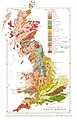 Geological map of Great Britain.jpg 1,036 × 1,614; 368 KB
-

-
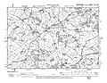 Laysters in Ordnance Survey Second Edition 1905 Sheet XIII. N.W.jpg 1,327 × 1,030; 462 KB
-

-
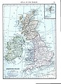 British Isles (1909).jpg 863 × 1,185; 805 KB
-
 D118- N° 443. La représentation anglaise en 1832. - Liv3-Ch17.png 1,450 × 1,725; 194 KB
-
 D306- N° 475. Londres et le genre humain. - Liv4-Ch01.png 1,436 × 1,495; 69 KB
-
 D352- N° 487. Côtes à ports nombreux. - Liv4-Ch02.png 1,445 × 1,932; 171 KB
-
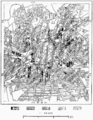 D379- N° 492. Slums de Manchester et Salford. - Liv4-Ch02.png 1,450 × 1,868; 476 KB
-
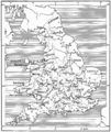
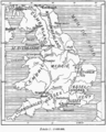 D384- Division de l’Angleterre en Royaumes. -liv3-ch2.png 1,445 × 1,804; 313 KB
-
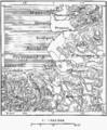 D496- N° 399. Chester et Liverpool. - liv3-ch14.png 1,437 × 1,742; 393 KB
-
 D497- N° 400. Les Cinque Ports. - liv3-ch14.png 1,440 × 1,444; 243 KB
-
 D520 - N° 298. Côtes occidentales de l’Ecosse. -liv3-ch5.png 1,448 × 1,750; 212 KB
-
 D521 - N° 299. Côtes septentrionales de l’Ecosse. -liv3-ch5.png 1,448 × 1,381; 208 KB
-
 D535-Basse Ecosse et Murs Romains.-Liv2-ch10.png 1,432 × 1,444; 342 KB
-
 D541-Voies Romaines en Angleterre.-Liv2-ch10.png 1,446 × 1,906; 272 KB
-

-
 Europe and other continents (1901) (14763679725).jpg 1,682 × 2,498; 748 KB
-
 P010 - N° 522. Isthme d’Écosse. - Liv4-Ch05.png 1,446 × 1,666; 635 KB
-
 P011 - N° 523. Estuaires orientaux d’Écosse. - Liv4-Ch05.png 1,439 × 1,823; 565 KB
-
 P273 - N° 563. Edimbourg et le Warrender Park. - Liv4-Ch08.png 1,448 × 1,822; 617 KB
-

-
 P316+P317 - Nos. 570+571. District Industriel de l’Angleterre.png 2,888 × 2,120; 1.37 MB
_(14595711607).jpg)


_Company%27s_illustrated_guide_to_the_sporting_and_touring_grounds_of_the_north_of_Ireland_(1908)_(14780428885).jpg)
.jpg)


_(1905)_(14598334887).jpg)
_(14763679725).jpg)


