
Category:1900s maps of Pittsburgh
Media in category "1900s maps of Pittsburgh"
The following 12 files are in this category, out of 12 total.
-
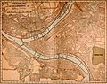 NIE 1905 Pittsburg - street map.jpg 2,187 × 1,733; 1.22 MB
-
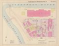
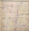 1907 Plat Map of 21 Ward shows Engine House No 16.jpg 1,494 × 1,600; 994 KB
-
 Exposition Park 1906.jpg 7,482 × 8,312; 3.1 MB
-
 Gallagher-Kieffer House2.png 1,219 × 500; 931 KB
-
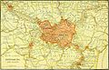 NIE 1905 Pittsburg - vicinity map.jpg 2,470 × 1,578; 1.05 MB
-
 Pauline H. Rosenberg House 3.png 773 × 451; 684 KB
-
 Pittsburgh 1902.jpg 7,256 × 4,856; 4.95 MB
-
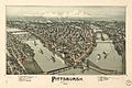
 Pittsburgh Volume 3 Plate 1.jpg 5,717 × 4,500; 820 KB
-
 Pittsburgh, Pennsylvania, 1902 WDL9575.png 1,530 × 1,024; 3.01 MB
-
 Westinghouse Works map 1904.jpg 800 × 635; 104 KB
-
 WPT pgh district map.png 2,176 × 2,160; 1.58 MB
-
 WPT pgh downtown map.png 2,825 × 4,499; 116 KB


