Category:1894 maps of New Hampshire
Jump to navigation
Jump to search
States of the United States: California · Connecticut · Illinois · Iowa · Kansas · Kentucky · Louisiana · Maine · Maryland · Massachusetts · Michigan · Minnesota · Mississippi · Missouri · Montana · New Hampshire · New York · North Carolina · Ohio · Oklahoma · Oregon · Pennsylvania · Rhode Island · South Carolina · South Dakota · Tennessee · Texas · Utah · Vermont · Virginia · Washington · West Virginia · Wisconsin · Wyoming – Washington, D.C.
| ← 1890 1891 1892 1893 1894 1896 1897 1898 1899 |
Subcategories
This category has only the following subcategory.
Media in category "1894 maps of New Hampshire"
The following 7 files are in this category, out of 7 total.
-
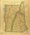 Map of New Hampshire and Vermont.jpg 2,933 × 3,443; 2.69 MB
-

-

-

-
 Sanborn Fire Insurance Map from Newton, Rockingham County, New Hampshire. LOC sanborn05369 001.tif 6,450 × 7,650; 141.17 MB
-

-
 Sanborn Fire Insurance Map from Warner, Sullivan County, New Hampshire. LOC sanborn05393 002.tif 6,450 × 7,650; 141.17 MB


