Category:1889 maps of Canada
Jump to navigation
Jump to search
| ← 1880 1881 1882 1883 1884 1885 1886 1887 1888 1889 → |
English: Maps of Canada from 1889 or related to Canada in 1889
Français : Les cartes du Canada de 1889 ou se rapportant au Canada en 1889
Media in category "1889 maps of Canada"
The following 14 files are in this category, out of 14 total.
-
 'Family Without a Name' by Georges Tiret-Bognet 06.jpg 800 × 590; 122 KB
-
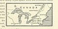
 428 of '(Handbook of Commercial Geography.)' (11219553284).jpg 2,304 × 1,426; 803 KB
-
 428 of 'Handbook of Commercial Geography' (11199372153).jpg 2,288 × 1,420; 821 KB
-
-

-
 New Glasgow, Nova Scotia (2675072170).jpg 2,000 × 1,410; 2.64 MB
-
 St. Stephen, New Brunswick and Calais, Maine (2675890254).jpg 2,000 × 1,421; 2.8 MB
-
 Truro, Nova Scotia (2674253115).jpg 2,000 × 1,421; 2.8 MB
-
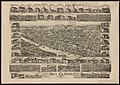
 Truro, Nova Scotia, 1889 LOC 2015655030.jpg 9,423 × 7,238; 17.64 MB
-
 Truro, Nova Scotia, 1889 LOC 2015655030.tif 9,423 × 7,238; 195.13 MB
-
 Victoria, B.C. 1889. LOC 75696734.jpg 12,080 × 8,080; 20.35 MB
-
 Victoria, B.C. 1889. LOC 75696734.tif 12,080 × 8,080; 279.25 MB
-
 Woodstock, New Brunswick (2675051926).jpg 2,000 × 1,510; 3.24 MB
-
 Yarmouth, Nova Scotia (2675047400).jpg 2,000 × 1,421; 2.94 MB

%27_(11219553284).jpg)
.jpg)
.jpg)
,_avril_1889_(22852808120).jpg)
.jpg)
.jpg)
.jpg)


.jpg)
.jpg)