Category:1886 maps of Canada
Jump to navigation
Jump to search
Provinces and territories of Canada:
Media in category "1886 maps of Canada"
The following 9 files are in this category, out of 9 total.
-

-
 18 of 'Free Niagara' (11185423515).jpg 2,202 × 2,949; 1.57 MB
-
-

-
 Canada provinces 1886-1889.png 1,000 × 864; 61 KB
-
-
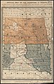
 Free homes in Manitoba and the Canadian North-West (microform) (1886) (20436990548).jpg 3,426 × 2,350; 1.4 MB
-
 Free homes in Manitoba and the Canadian North-West (microform) (1886) (20437033740).jpg 1,988 × 3,116; 1.48 MB
-
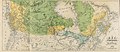
 Free homes in Manitoba and the Canadian North-West (microform) (1886) (20631623951).jpg 3,298 × 1,904; 1.14 MB
.jpg)
.jpg)

.jpg)

.jpg)
_(1886)_(20436990548).jpg)
_(1886)_(20437033740).jpg)
_(1886)_(20631623951).jpg)